Monday, September 18, 2023
We woke this morning to a beautiful sunny day with a temperature of 56 degrees. We left LaConner Thousand Trails in LaConner, Washington at 8:10 a.m. to travel 215 miles to Oceana Thousand Trails in Ocean City, Washington.

We headed out on US Hwy 101 toward Aberdeen and Port Angeles, which was now 10 miles away.


We crossed under a neat arched bridge on our way.


As we continued down the highway, Aberdeen is now 42 miles away and then soon just 35 miles away.


Now Aberdeen is only 25 miles away.

We now see the "Welcome to Aberdeen" sign (shown above) that also says, "Come as you are."

(Shown above is a view of downtown Aberdeen, Washington from the US 101 bridge.)

Aberdeen is in Grays Harbor County, Washington. It has a population of 17,013 and is the economic center of Grays Harbor County, bordering the cities of Hoquiam and Cosmopolis. Aberdeen is occasionally referred to as the "Gateway to the Olympic Peninsula". Aberdeen was named after a local salmon cannery to reflect its Scottish fishing port namesake Aberdeen, and like Scotland, Aberdeen is situated at the mouth of two rivers - the Chehalis and the Wishkah.
The city was founded by Samuel Benn in 1884 and incorporated on May 12, 1890. Although it became the largest and best-known city in Grays Harbor, Aberdeen lagged behind nearby Hoquiam and Cosmopolis in its early years. When A.J. West built the town's first sawmill in 1894, the other two municipalities had been in business for several years. Aberdeen and its neighbors vied to be the terminus for Northern Pacific Railroad, but instead of ending at one of the established mill towns, the railroad skimmed through Cosmopolis and headed west for Ocosta. Hoquiam and Aberdeen citizens together built a spur in 1895, the line connected Northern Pacific tracks to Aberdeen.

By 1900, Aberdeen had become home to many saloons, brothels, and gambling establishments. It was nicknamed "The Hellhole of the Pacific", as well as "The Port of Missing Men" due to its high murder rate. One notable resident was Billy Gohl, known locally as Billy "Ghoul", who was rumored to have killed at least 140 men, disposing of the bodies in the Wishkah River. Gohl was ultimately convicted of two murders.
Aberdeen was hit hard during the Great Depression, which saw the number of major local sawmills reduce from 37 to 9. The timber industry continued to boom, but by the late 1970s most of this resource had been logged and by the early 1990s the industry was decimated due to resource reduction. Local political and business leaders ignored this fact and did not pursue economic diversification. Most of the mills had closed down by the 1970s and 1980s.

The Young Street Bridge (shown above) has a couple other names, including its official name -- the North Aberdeen Bridge or “Kurt’s Bridge” named for Nirvana’s founder, the legendary Kurt Cobain, who grew up in Aberdeen. Cobain wrote songs underneath the bridge, including “Something in the Way,” which refers specifically to the Young Street Bridge. And people from around the world come to it, sit under it, and hang out at Kurt Cobain Memorial Park, which sits at the southern side of the bridge.

(Cobain playing drums at Montesano High School in 1981.)
Kurt Donald Cobain (1967 – 1994) was an American musician, singer, and songwriter. He became known as the co-founder, lead vocalist, guitarist, and primary songwriter of the rock band Nirvana. Through his angst-fueled songwriting and anti-establishment persona, his compositions widened the thematic conventions of mainstream rock music. He was heralded as a spokesman of Generation X and was widely recognized as one of the most influential alternative rock musicians.

Cobain formed Nirvana with Krist Novoselic and Aaron Burckhard in 1987 -- establishing themselves as part of the Seattle music scene that later became known as grunge. Burckhard was replaced by Chad Channing before the band released their debut album Bleach (1989) on Sub Pop, after which Channing was in turn replaced by Dave Grohl. With this finalized line-up, the band signed with DGC and found commercial success with the single "Smells Like Teen Spirit" from their critically acclaimed second album Nevermind (1991). Cobain wrote many other hit Nirvana songs such as "About a Girl", "All Apologies", "Aneurysm", "Come as You Are", "Heart-Shaped Box", "In Bloom", "Lithium", "Something in the Way", and "You Know You're Right".
During his final years, Cobain struggled with a heroin addiction and chronic depression. He also struggled with the personal and professional pressures of fame, and was often in the spotlight for his tumultuous marriage to fellow musician Courtney Love, with whom he had a daughter named Frances. In March 1994, he overdosed on a combination of champagne and Rohypnol, subsequently undergoing an intervention and detox program. On April 8, 1994, he was found dead in the garage of his Seattle home at the age of 27, with police concluding that he had died around three days earlier from a self-inflicted shotgun wound to the head.

Aberdeen was also the home port of the tall ship Lady Washington (shown above), a reproduction of a smaller vessel used by the explorer Captain Robert Gray, featured in the Pirates of the Caribbean film, "The Curse of the Black Pearl".
Lady Washington became the first American vessel to visit the West Coast of North America, beginning what would become the Pacific Fur Trade. Built by Grays Harbor Historical Seaport in Aberdeen, Washington, and launched in 1989 as a Washington State Centennial project, the reproduction Lady Washington sails the waters of Washington State and the West Coast of North America as the official ship of the state of Washington.
While we were in Aberdeen, we stopped at the Taco Bell for lunch. We each had two Chipotle Ranch Grilled Chicken Burritos and a senior drink.

Shortly afterwards, we were in the city of Hoquiam, located in Grays Harbor County, Washington. It borders the city of Aberdeen at Myrtle Street, with Hoquiam to the west. The two cities share a common economic history in lumbering and exporting, but Hoquiam has maintained its independent identity. It shares a long rivalry with its more populated neighbor, especially in high school sports.
.jpg)
(Downtown Hoquiam.)
Hoquiam was incorporated on May 21, 1890. Its name comes from a Native-American word meaning "hungry for wood", from the great amount of driftwood at the mouth of the Hoquiam River. The population is 8,776.
One of the first logging operations in Hoquiam was established by Ed Campbell in 1872. About 10 years later, Captain Asa M. Simpson, a Pacific Coast mariner and businessman in the lumber industry from San Francisco, provided the financing for the Northwestern Mill. In 1881, Simpson sent his manager, George Emerson, to Hoquiam to establish a mill there, and Emerson purchased 300 acres for the new mill and lumber operation. By September 1882, the Simpson mill was producing its first lumber products.
In 1886, Captain Simpson merged his mill with the Miller Brothers mill, also located in Hoquiam, and named it the Northwest Lumber Company. The mill was later renamed the Simpson Lumber Company, and retained that name until 1906. In 1913, Frank J. Shields became the new manager at the mill at Hoquiam.
The extension of the railroad from Aberdeen to Hoquiam, beginning in 1898, contributed to the continued importance of logging and lumber in Hoquiam. The importance of logging and related products continued to be relevant to Hoquiam's economy, and in 1927, a pulp mill was established under the name of Grays Harbor Pulp Company. A year later, a Pennsylvania company- the Hammermill Paper Company- became interested in Grays Harbor Pulp Company. When the Pennsylvania company bought stock in the Grays Harbor Pulp Company, the Grays Harbor pulp Company built a paper mill and became the Grays Harbor Pulp & Paper Company. In 1936, the Grays Harbor Pulp and Paper Company merged with Rayonier Incorporated, a company which manufactured a certain kind of wood pulp used by its customers to produce rayon.

We continued on following US 101 North toward Port Angeles.

Ocean City is now 16 miles away and Ocean Shores is 18 miles away.


We are now 2 miles from Ocean City.
Ocean City is a census-designated place in Grays Harbor County, Washington with a population of 200. It is bordered to the north by Copalis Beach, to the south by Hogans Corner, to the east by State Route 109 and Cranberry Creek, and to the west by the Pacific Ocean.


A local motel (North Beach Motel in Ocean City, Washington) featured Bigfoot running with a surfboard while flashing the ‘hang loose’ sign.
And then just a little ways down the road, we drove by the Ocean City Market Place, which has wood chainsaw carved yard sculptures right on the bend of Hwy 109 in Ocean City.


Above and below are a few of these sculptures that we will stop and take a better look at another day.


On the way to the Thousand Trails campground we first drove by the Ocean RV Resort.

Then just 0.3 of a mile down the road on WA 109 North, we arrived at the Oceana Thousand Trails in Ocean City, Washington at 12:45 p.m.


We got checked in and set up on site #9 for seven nights.


We just hung around the campground for the rest of the day. For dinner, we had grilled chicken thighs and foil packets with potatoes, carrots, onions and peppers.
Tuesday, September 19, 2023
Today started out cloudy at 54 degrees, however that didn't stop us from going sightseeing. We stopped for gas at the Safeway in Aberdeen, Washington before beginning our journey.

Today, we headed out at 8:45 a.m. to the Olympic National Park. At more than 1,400 square miles, the vast wilderness contained in Olympic National Park boasts a diverse variety of terrain for visitors to experience, from the Hoh Rain Forest to the Pacific coast and into the peaks of the Olympics.

(Shown above is the map of Olympic National Park.)
The Olympic National Park is known as three magical parks in one, a land of beauty and variety. Created in 1938 to protect the Roosevelt elk, primeval forest and wild coast, the park encompasses nearly a million acres. There are breathtaking mountain vistas with meadows of wildflowers to colorful ocean tidepools or early homestead cabins. Nestled in the valleys are some of the largest remnants of ancient forests left in the country. Trees here can tower 300 feet tall, and the forests range from the westside's lush temperate rain forest to dry, fire-shaped eastside forests.
Waves boom along wilderness beaches and mix with snow-fed rivers. Ancient trees shelter wildlife. Rugged peaks embrace glaciers and subalpine meadows. Coast, forest, and mountain ecosystems combine to create this spectacular wilderness park. The Olympic Peninsula is home to eight American Indian tribes that developed complex hunter-gatherer societies and continue to keep their traditions alive. European explorers who ventured here in the late 1700s heralded the way for homesteaders. The Olympics were set aside as a national monument in 1909 and further protected as Olympic National Park in 1938. Today the park is internationally recognized as a Biosphere Reserve and World Heritage Site, testimony to its rich resources.
COAST
Tides control the rhythm of life along this biologically diverse coastline. Twice-daily intertidal animals face pounding surf and drying winds. Coastal rivers serve as highways for migrating fish, and downed trees along riverbanks protect young salmon journeying from mountains to sea. When the adults return and swim upstream to spawn, their flesh carries a special form of nitrogen gathered during their years at sea. Most salmon die after spawning, but their death brings life. Bears, eagles, insects, and other animals feed on salmon carcasses, then deposit nutrients in rivers and forests. Marine nitrogen nourishes forest soils—a gift from the salmon.
FORESTS
Olympic National Park protects the largest old-growth forest in the Pacific Northwest. Its unique character begins with ancient trees that took root 200 to 1,000 years ago. In these forests multi-layered canopies, standing snags, and fallen trunks provide habitat for myriad animals. Differences in moisture (from 40 to 240 inches annually), and changes in elevation (from sea-level to 7,980 feet) create a mosaic of forests in the park. Temperate rain forests grow along the coast and in ocean-facing valleys. Lowland, montane, and subalpine forests cloak other park areas. Olympic supports complex forest communities—a gift from the past.
MOUNTAINS
A world of landscapes unfolds here: glaciers chisel U-shaped valleys, and brilliantly colored wildflowers blanket subalpine meadowy Geologists still debate the origins of the Olympics. Some 50 million years ago lava gushed from underwater rips in the edge of the continent, hardening into miles-thick layers of basalt. Later an immense submerged delta of sandstone and shale formed farther out in the ocean. These layered rocks slowly rode back to the continent and jammed beneath the basalts, forcing the Olympics to rise from the sea 10 to 20 million years ago. Ice-age glaciers helped carve the Strait of Juan de Fuca and Puget Sound, separating the Olympics from nearby lands. Years of isolation nurtured the rich biodiversity of the Peninsula, where over 20 plants and animals are found nowhere else on Earth. The rugged Olympic Mountains—a gift from the sea.

Because there is so many acres of just wilderness in the Olympic National Park, we had to drive for awhile before we actually got to something to see up close.

We headed toward Lake Quinault and the rain forest. The Quinault Valley is a wilderness gateway to alpine meadows, jeweled lakes and ice-carved peaks. The valley also has a scenic loop drive with short trails through temperate rain forest in both Olympic National Park and Olympic National Forest.


Shown above is the sign for the Olympic National Forest.


We soon came to the sign that said "South Shore Road, Quinault Next Right" which is where we wanted to go.

We turned right here and followed the road to Quinault, which was now 2 miles away.


We drove by Willaby Campground.

We have now entered Quinault, Washington. Quinault is an unincorporated community in Grays Harbor County, Washington, located on the Olympic Peninsula. Lake Quinault is the location of Lake Quinault Lodge, which is listed on the National Register of Historic Places. Quinault is on the windward side of the Olympic mountains, which gives it an oceanic climate with a very wet (139 inches of precipitation) falling each year. It is one of the wettest places in Washington state.


(Shown above is the Museum in Quinault.)

(Shown above and below is Lake Quinault Lodge in the Olympic National Park.)

Lake Quinault Lodge is a grand and rustic lodge built in 1926 in the heart of the Quinault Rain Forest among ancient Sitka spruce, Douglas fir, western red cedar, and western hemlocks, on the south shore of Lake Quinault. The two-story historic lodge was built in the mid-1920s and has welcomed thousands of visitors from all over the world including President Franklin D. Roosevelt in the early 1930s.

We drove on through the rain forest.


It is here that we officially entered the Olympic National Park (see above). We drove along the South Shore Road to Bunch Falls and Merriman Falls.

(The map above shows the location of Bunch Falls and Merriman Falls.)

Bunch Falls (shown above and in the next few pictures) is the tallest of the major waterfalls in the lower Quinault area, skipping about 60 feet down a mossy wall just feet inside the boundary of Olympic National Park. The falls are among the most photographed water features in the area due to their accessibility. The falls are located immediately inside of Olympic National Park along the Quinault River Road about 10 miles east of the Lake Quinault Lodge and are hard to miss.


(Shown above is a photo of Bunch Falls from the bridge in the spring.)

(Shown above and below is Lake Quinault from the spot where we pulled over to take pictures of Bunch Falls.)

After we saw Bunch Falls, we turned back around and went back to take a few pictures of Merriman Falls that we had missed on the way in to Bunch Falls.


Merriman Falls (shown above) is the most accessible waterfall in the Lake Quinault area of the Olympic Peninsula. The falls plunge about 40 feet over a cliff before splashing through a pile of rocks and logs covered in all sorts of mosses and ferns and passing under the road towards the Quinault River. The falls are one of the most popular attractions in the Quinault area due to its ease of access, yet at the same time its a very little known waterfall among the various popular waterfalls in the Olympics. Merriman Creek has a rather small catchment basin, so expect it to be reduced in stature in the summer and fall.
The falls were located immediately next to the South Shore Road just outside of Olympic National Park, east of Lake Quinault. We drove about 3-1/2 miles past the Gatton Creek Campground, which is in turn 1 mile beyond the Lake Quinault Lodge, to a large turnout along the road next to the bridge over Merriman Creek.


(Shown above is what Merriman Falls looks like in late spring.)
After seeing the falls, our next stop was to go see the Quinault Big Sitka Spruce Tree, that is a World's Record. Estimated to be roughly 1,000 years old, the World’s Largest Spruce tree stands 191 feet tall, and is 17.7 feet in diameter. It also has a circumference of 58 feet, 11 inches, with a total volume of 10,540 cubic feet and an impressive crown spread of 96 feet.


(Shown avove a sign points you to the short path from the parking lot.)
To access the Quinault Giant Sitka Spruce, you'll only need to walk a short 0.4 miles one-way from South Shore Road on a well-maintained, relatively flat gravel trail.

At the start of the trail to see the World's Largest Spruce tree, was the above tree. A posted sign said "Beware of Bees -- Winnie the Pooh." Makes you wonder if there might be some bees inside this tree.

(Shown above is the path to the giant tree.)

We continued a short distance further and voila there is was just past the bridge shown above!

The awesome Sitka Spruce tree stretched like what seemed like forever skyward.

The above sign told us all the pertinent information on this giant tree.

In the picture shown above, Mel is down bay the base of the giant tree. I couldn't even get the entire tree in the picture from where I took this shot. But it really whow you how big the tree is in diameter.

I took the above picture on our way back across the bridge -- note the people standing down by the base of the tree.

We then walked the short trail back to our truck and continued our journey in Olympic National Park.

(Shown above is Lake Quinault.)

We drove by Falls Creek Campground in the Olympic National Forest and then by the Northshore Road Loop to the Quinault Rain Forest.

We stopped at Amanda Park Mercantile in Amanda Park, Washington. Amanda Park is a census designated place on the Olympic Peninsula in Grays Harbor County, Washington, along U.S. Route 101, with a population of 252. Olympic National Park and Lake Quinault are directly to the north. It is in the northeast corner of the Quinault Indian Nation. U.S. 101 passes through the center of the community, leading northwest 25 miles to Queets on the Pacific coast and south 43 miles to Aberdeen. With an average annual precipitation of 129.28 inches, Amanda Park is one of the rainiest locations in Washington state.

At the Amanda Park Mercantile, we bought some corn dogs for a quick lunch (see photo below).


We then continued on past the Upper and Lower Queets Valley.


Shown above you can see where they have been logging quite a bit.

The Hoh Clearwater State Forest is on the right ahead.

We crossed over the Queets River and continued on toward South Beach.


We kept on driving past Beach 1 and Beach 2, with only slight glimpses of the actual beaches due to all the heavy vegetation and the heavy sea mist.


We drove by the Kalaloch Ranger Station, and then the Kalaloch Creek.


We passed the turnoff for the Kalaloch Campground and then just around the bend, we could finally see a portion of the Pacific Ocean.


The wind was pretty fierce, and we called it a wicked water day in the Pacific Ocean with waves crashing into the shoreline.


We didn't stop, but continued on past Beach 3 and Beach 4.


Since we were on our way to the Hoh Visitor Center, we drove by the Big Cedar Tree and Ruby Beach, and continued on.


When K'wati got to the Hoh River he discovered that the inhabitants of the area were upside down people, who walked on their hands and handled their smelt dip nets clumsily with their feet. They weren't very good at it, so they were famished and skinny. K'wati set them right-side up and showed them how to operate their nets with their hands. For that reason, Hoh elders still sometimes refer to themselves as p'ip'isodat'sili, which means "Upside down people." After he had set the Hoh upright, then, the Transformer told the Ancestors, you shall use your feet to walk… Go and fish smelt. You shall catch much fish when you fish smelt." Ever since then there is a bounty of smelt at Hoh.
So important is the river in tribal lifeway's that there is also, not surprisingly, a mythic narrative for the origin of the river. The Hoh River and the headlands along the beaches (Toleak Point and Hoh Head) were created by K'wati, as well. According to the story, K'wati killed the chief of the wolves, and then tried to escape from the other wolves, which were bent on revenge. The wily Transformer had grabbed his carved comb and a container of oil when he fled from his house, even though the wolves were in hot pursuit. According to the story, then K'wati ran down the beach. Then the wolves followed K'wati intending to kill him. As soon as the wolves were about to overtake K'wati, he used what had been hanging in the house [i. e. the comb] and struck the ground with it on the beach. No sooner had K'wati finished striking the ground on the beach with his comb and there appeared a cliff. Of course, the wolves had to swim around the cliff. Then the wolves would be left far behind. Once more the wolves were about to overtake K'wati and he spilled on the ground what he was carrying [i. e. the oil], there appeared a river. Of course the wolves had to swim across the water. Then K'wati kept on going and as soon as they would be about to overtake him, he would… make cliffs and rivers. So, he went around the country and K'wati was never overtaken by the pursuing wolves. Ever since that time there are cliffs and rivers.

We were soon at the Hoh Rain Forest. Hoh Rainforest is one of the largest temperate rainforests in the U.S., located on the Olympic Peninsula in western Washington state. It includes 24 miles of low elevation forest 394 to 2,493 feet along the Hoh River. The Hoh River valley was formed thousands of years ago by glaciers. Within Olympic National Park, the forest is protected from commercial exploitation. Between the park boundary and the Pacific Ocean, 30 miles of river, much of the forest has been logged within the last century, although many pockets of forest remain. Hoh Rainforest is the wettest forest in the Contiguous United States, receiving over 100 inches of rain per year.

We drove by the Hoh Oxbow Recreation Area and the Cottonwood Recreation Area.
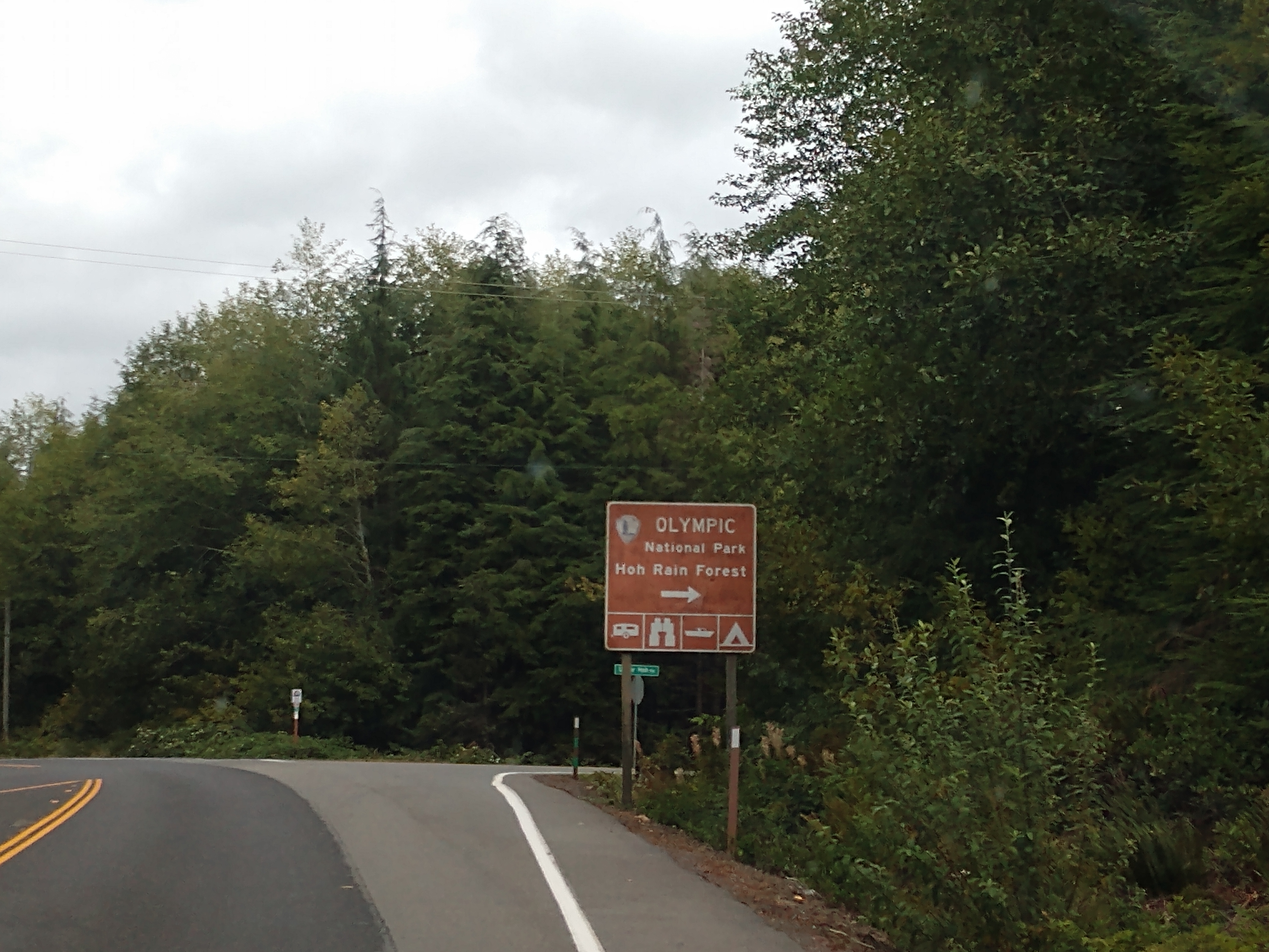
We then turned right to go to the Hoh Rain Forest.

The Olympic National Park Entrance station is now 12 miles away and the Visitor Center is 18 miles away.

As we continue along the road, we have once again hit road construction,so this slows us down a bit.


We will be experiencing a one-lane road ahead.


Not so sure what they are doing here -- looks like a whole bunch of old bridge pillars.


The s.v. Nikolai Monument is just head. It is a monument recognizing the ship wreck of the Sv. Nikolai. This is one of the most beautiful spots in the West End. Located 12 miles from Forks, the rugged shoreline with its amazing beauty produces a unique experience and amazing photos, but for one newlywed Russian couple an unscheduled stopover at this breathtaking location it would prove to be anything but a honeymoon.

Here's how the story goes . . .
Nikolai Bulygin was the captain of the Sv. Nikolai, a schooner about 45 feet long. Bulygin was sent in 1808 to explore the coast of Washington for possible new settlements. Eighteen year old Anna Petrovna had just married Nikolai and accompanied him on the trip. The voyage had a mandate from Alexander Baranov, the head of the Sitka base, to gather information in advance of Russian colonization.
Anna and her husband Nikolai, along with following Russian fur hunters (known as promyshlennik), an Englishman, Aleut men and women, and a part-Russian teenager went ashore on November 1, 1808. This was after almost a week of being adrift and tossed around by gale force winds and large swells in the turbulent Pacific Ocean, drifting from Destruction Island southwest of the Hoh River north about 20 miles to the beach near LaPush.
After escaping the sinking vessel and reaching the shore, the party used sails draped over wooden yards from the shipwreck as tents. They lit a fire and prepared to head south dozens of miles to Grays Harbor where they hoped a companion Russian ship, the Kad’iak, would pick them up.
Almost immediately there were problems with the Quileute, Hoh and Makah, who were accustomed to fighting each other and strangers. Anna was captured and her husband went a bit insane, refusing to give up his search for her, no matter how many of his crew died or were captured. At one point Anna was brought back for ransom, but the price demanded was the guns of the Russians. Without them, they would have no way of hunting food or protecting themselves, so although Bulygin begged his men, they refused and Anna was taken away.
In the spring, the castaways finally were led to Anna. The Russians had managed to take some women themselves as hostages and hoped that Anna could now go free. To their shock they heard Anna say that she was satisfied with her condition and did not want to rejoin the Russians and she advised them to surrender themselves. Bulygin collapsed at the news. Later he and part of the remaining crew surrendered to the Indians and they eventually found themselves traded as slaves. As slaves, Bulygin and Anna were together at times. Anna Petrovna died in August 1809. A heartbroken Bulygin died of advanced consumption the following February. The survivors were rescued by American fur traders in May 1810.
It was during their miserable stay around Dec. 10, 1808, when snow started to fall, that the party decided to build a structure on the upper Hoh. To commemorate their story, the Association of Washington Generals sought donated land near the Hoh Rain Forest believed to be at or near the original location where the Russian survivors once took refuge.
The memorial is shown below . . .


This above monument commemorates the 1808 expedition of the Russian American Company sailing vessel Sv. Nikolai and its crew of 22 explorers who were stranded when their 45-foot schooner went aground on the Pacific Coast north of the Quillayute River. The journey of the Nikolai is one of a shipwreck and survival through the harshest of conditions, of love and, ultimately, reconciliation among peoples of diverse backgrounds and cultures. Eventually all the Sv. Nikolai crew and passengers were taken into captivity and divided among the Hoh, Quiluete and Makah people. Sv. Nikolai Captain Nikolai Bulygin and his young wife Anna Petrovna, perished during this incident. The Sv. Nikolai incident is the first recorded shipwreck known in Washington State. Anna Petrovna is believed to be the first non-native woman to land on the shores of lands that became Washington State.

The above storyboard illustrated the story of the Sv. Nikolai Mission in a verbatim acount:
In September 1808, the Russian American Company schooner Sv. Nikolai set sail from the Russian American Company's fort in Sitka, which was then in Russian territory (now part of the State of Alaska). They sailed on a reconnaissance expedition to New Albion (Oregon Territory). Leading the party is junior Russian naval officer Captain Nikolai Bulygin, joined by his young wife, Anna Petronva Bulygin, a team of promyshlenniks (expert fur hunters), Englishman John Williams, plus five men and two women from the Alutiiq Tribe on Kodiak Island, a native people who the Russians call Aleuts. The ship is on a mission under orders from RAC Governor Alexandr Baranov to find a base for hunting, trading, agriculture with hopes of establishing a permanent colony. Sea otter pelts were then highly valuable trading items for export to China, Europe, and America. Great Britain fighting Napoleonic-era battles, and the Spanish pulling back to California missions from the Pacific Northwest, have created an opening for Russian colonization from Sitka south to San Francisco. Long strands of colorful trading beads fill chests stowed in the hold, ready to be traded for furs to underwrite the voyage. A rendezvous is planned at Grays Harbor in the spring with the RAC ship Kad’iak. However, plans for the rendezvous and opening of a new settlement are cancelled by the force of a harsh Northwest ocean storm, and the course of history is changed for what will become the coast of Washington State.
The next section tells the verbatim story of the Storm at Sea and War on Land:
In late October 1808, the Sv. Nikolai runs into a horrific storm at sea off the Northwest coast. The schooner's crew loses control of its rudder and drifts in high surf and storm waves until grounding on a black sand and gravel beach about a mile and a half north of the mouth of the Quillayute River and the Quileute Tribe's settlement at La Push. The survivors are joyous to be ashore following a storm-driven ordeal along the West End coast that constantly threatened their lives, a crisis at sea where the Sv. Nikolai narrowly misses colliding with sea stacks and rocky islets. The crew salvages what they can from the schooner, places it ashore, and waits for contact with the Quileutes. The Quileute, the Hoh Tribe to the south, and the Makah Nation to the north all dwell in this land. The tribes see the arrival of the white-skinned ho'kwat (wanderers) in mythical and territorial terms. This coast is their ancestral homeland, a place to be defended when outsiders arrive in fear of being attacked and taken away as slaves. The Russian American Company party sees the region as a wild untapped place of natural riches to be claimed. The native people are seen as a source of obtaining those riches and a hindrance. Seeing the Russian camp fire and goods, Quileute warriors begin to search the mysterious cargo of the ho'kwat, and the promyshienniks push them away. The warriors pick up smooth beach stones, throwing them at the shipwrecked party, and pierce some with spears. The Russians open fire with muskets. The warriors flee leaving two dead by the camp on the beach.

We continued along the heavy forested road.


Soon we were at the beginning of the Olympic National Park Hoh Rain Forest.

The Hoh Rainforest is one of the largest temperate rainforests in the U.S. that is located on the Olympic Peninsula in western Washington state.

Above is the entrance station into the Olympic National Park. This park would have cost us $30 admission, but since I have the America The Beautiful - National Parks and Federal Lands Senior Lifetime Pass, we got in free.

The above sign says were are at an elevation of 573 feet above sea level here.

The Olympic National Park was designated as a World Heritage Site on October 27, 1981.

Shown above is the Hoh Rain Forest Visitor Center. Since they didn't have any films to watch, we just looked around.

Above is the cumulative rainfall gauge. Looks like they have received 65 inches of rain as of the time we were there.

I found the above information about the Roosevelt elk very interesting. It told us that the Olympic National Park protects the largest unmanaged herd of Roosevelt elk in it natural environment.With Roosevelt elk hunted to near extinction in the early 1900s, one of mandates for the establishment of the park in 1938 was to provide suitable winter range and permanent protection for the herds of native Roosevelt elk and other wildlife. As wildlife becomes overly accustomed to humans, some animals lose their natural wariness. Habituated Roosevelt elk can be dangerous.

We walked outside of the visitor center and looked at some of the Hoh rainforest. The Hoh Rain Forest is located in the stretch of the Pacific Northwest rainforest which once spanned the Pacific coast from southeastern Alaska to the central coast of California. The Hoh is one of the finest remaining examples of temperate rainforest in the United States and is one of the park's most popular destinations. The Hoh lies on the west side of Olympic National Park, about a two-hour drive from Port Angeles and under an hour from Forks. The Hoh Rain Forest is accessed by the Upper Hoh Road, off of Highway 101.

The Hoh Rain Forest, pronounced "Hoe", earns its name from the ever-flowing Hoh River that carves its way from Mount Olympus towards the Pacific Coast. However, where the name originates, is up for debate. The word "Hoh" undoubtedly comes from Native American languages; possibly the Quileute word "Ohalet" which means "fast moving water" or "snow water." Since the river itself forms from glacial runoff, that origin seems straightfoward. Other explanations state that the Quinault word "Qu," meaning "boundary," could be the root of the name as a river as massive as the Hoh certainly forms a formidable boundary across the landscape. A third consideration claims that the word "Hoh" translates to "man with quarreling wives." What the actual history behind the name is appears to be lost to time.
Regardless of the name, there's no question as to the allure that draws visitors back to the rainforest year after year. Throughout the winter season, rain falls frequently in the Hoh Rain Forest, contributing to the yearly average of 140 inches of precipitation each year. The result is a lush, green canopy of both coniferous and deciduous species. Mosses and ferns that blanket the surfaces add another dimension to the enchantment of the rainforest.


Shown above is another Olympic National Park sign. After laving the Hoh Rainforest area, we drove back along the coast and stopped at Ruby Beach.

Ruby Beach is the northernmost of the southern beaches in the coastal section of Olympic National Park. It is located on Highway 101 in Jefferson County, 27 miles south of the town of Forks. Like virtually all beaches on the northern coast, Ruby Beach has a tremendous amount of driftwood. The beach is so called Ruby Beach because of the ruby-like crystals in the beach sand.

The water was extremely wicked today as shown in the picture above and below from the Ruby Beach area.


Next, we stopped at the Kalaloch Lodge. Kalaloch Lodge is an Olympic National Park hotel property located a few sandy steps from the pristine Pacific coast, tucked between lowland forest, temperate rainforest and the marine sanctuary.


Shown above and below is the view of the Pacific coast through the arch at the Kalaloch Lodge.


Driftwood piles up along the beach at the Kalaloch Lodge.

Next, we drove down to the South Beach Campground and beach area. South Beach Campground is located off of Highway 101 in the Kalaloch Area right along the Pacific Ocean. The Kalaloch Area is 36 miles south of Forks, WA.


Shown above and below are views of the Pacific Ocean from the South Beach Campground.


There is a trail at South Beach down to the beach that is a bit steep. The beach is beautiful and full of large driftwood logs.


After a long day out sight-seeing (cover 163 miles in the Olympic National Park), we got back to our campsite at around 4:30 p.m.
Wednesday, September 20, 2023
After a long day of sight-seeing yesterday, we decide to take it a little easier today. We left around 9:30 a.m. to sunny skies and 54 degrees.

Our first stops of the day were at the Walmart and Safeway in Aberdeen, Washington to get groceries. We then filled up with gas at the Safeway as well. We then went back to the camper to put the groceries away and have a quick lunch.


At 1:40 p.m., we headed back out with our first stop being the Quinault Beach Resort and Casino in Ocean Shores, Washington.

Located on the beach at Ocean Shores, the Quinault Beach Resort and Casino is surrounded by the majestic Pacific Ocean and nestled amidst over 200 acres of protected wetlands, offering views of unparalleled natural beauty. With three restaurants to choose from and a Vegas style casino with over 500 slot machines, a poker room, and 12 table games, the Quinault Beach Resort and Casino was one of our favorites!

We went inside the casino and got signed up for the new player cards. We each received $25 in free play, and together when we were done playing the slot machines, we walked out of the casino with $66 of earnings. Woohoo!

Our next stop was at the Elk Head Taproom in Ocean Shores, Washington.


Mel enjoyed a few craft beers.

And I enjoyed a glass of ice water, while playing the horseshoe puzzle.

This horseshoe puzzle (shown above) is a classic that's been around for many years, and I even had one as a child. Two horseshoes are permanently joined with short sections of chain, and a metal ring encircles the chains and appears to be irremovable from the apparatus. And, just like riding a bicycle, if you know the technique, you will never forget how to solve it!
Ta-da! I solved it (see below).

If you really are interested in being able to solve this same puzzle, and this a spoiler alert -- here's how (see below).

After that, we stopped at the Dollar General in Ocean Stores to pick up a few groceries, and then made a quick stop at the IPA store to get a bag of ice. We got back to campground at around 4:40 p.m.

Mel went on a walk down to the beach from the campground and performed the ritual that we always do at beaches (writing in the sand as shown above).
%20ADD%20TO%20SEPT%2020.jpg)
For dinner tonight, we had pork chops and salads.
There were many beautiful places to see in the Olympic National Park, and even a brain teaser to solve on our journey the past few days. Stay tuned for more of our adventures.
Shirley & Mel


No comments:
Post a Comment