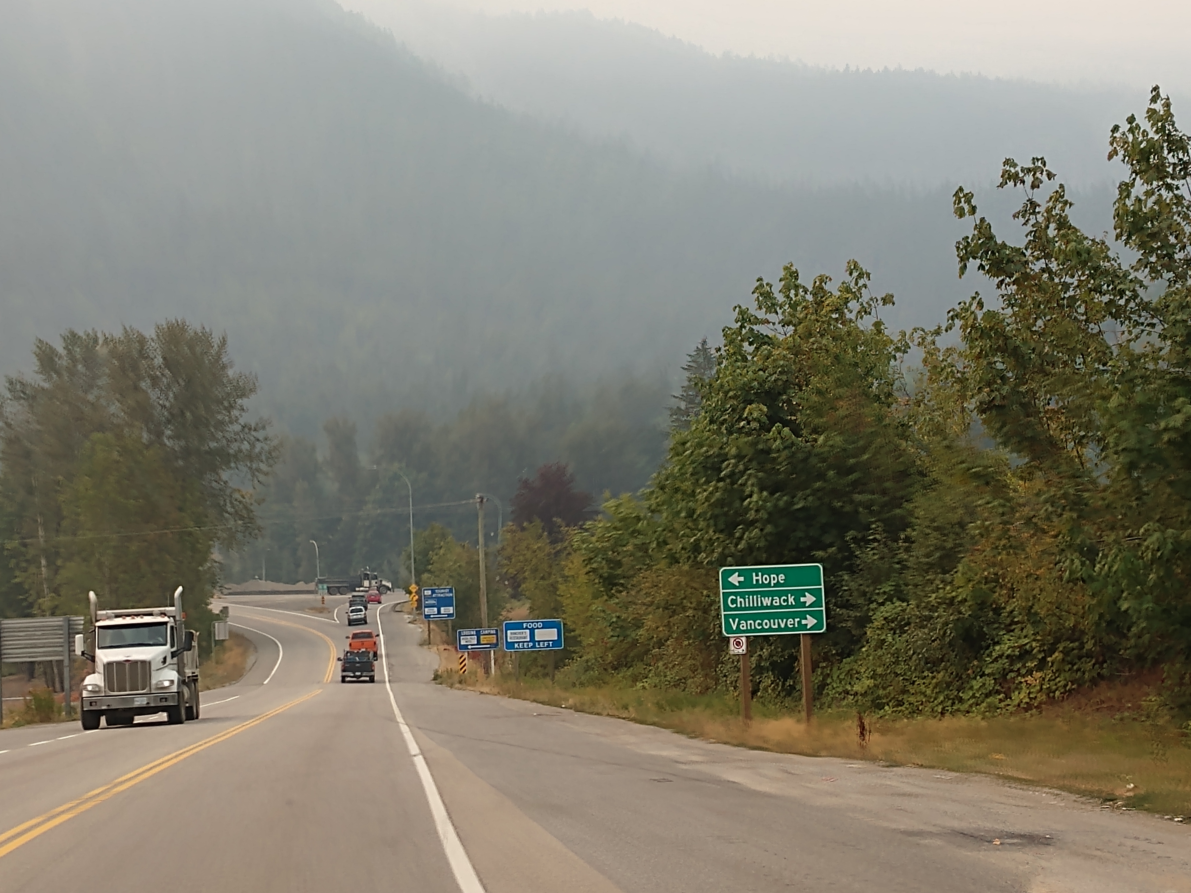
Vancouver is now 113 kilometers (or 70 miles) away, while Chilliwack is now 15 kilometers (or 9 miles) away.
We are now entering Chilliwack. Chilliwack is a city in the province of British Columbia that is surrounded by mountains and home to recreational areas such as Cultus Lake and Chilliwack Lake Provincial Parks. Chilliwack is known for its annual corn harvest. The Fraser Valley Regional District is headquartered in Chilliwack, which is the Fraser Valley's second-largest city after Abbotsford. The city has a population of 93,203.

By 1859, over 40,000 gold miners had trekked to the goldfields of the upper Fraser River, many traveling through the Chilliwack area. By the mid-1860s, several farms had grown up around the steamboat landings on the Fraser River called Miller's Landing, Minto Landing, Sumas Landing and Chilliwack Landing.
The Township of Chilliwhack was incorporated in 1873, the third municipality in British Columbia. The initial settlement was along the Fraser River at Chilliwack Landing. Steamboats were the main mode of transportation, carrying goods and passengers between Chilliwack and New Westminster. After the construction of the Canadian Pacific Railway in 1885, many residents began to cross the Fraser River at Minto Landing to catch the train at Harrison Mills.
With little room for expansion along the river, the commercial area of the town moved south to the junction of the New Westminster-Yale Wagon Road, Wellington Avenue and Young Road, called "Five Corners". A large subdivision called Centreville was built in 1881. The name "Centreville" was replaced in 1887 by the more popular "Chilliwack."


Vancouver is now 93 kilometers (or 58 miles) away, while Abbotsford is now 29 kilometers (or 18 miles) away.
We are now entering Abbotsford. Abbotsford is a city located in British Columbia, next to the Canada–United States border, Greater Vancouver and the Fraser River. With a census population of 153,524 people, it is the largest municipality in the province outside metropolitan Vancouver.
It is the largest municipality of the Fraser Valley Regional District and the fifth-largest municipality of British Columbia. The community 145 square miles and is the largest city by area in British Columbia. The municipality's southern boundary is the Canada–United States border. In Canada, it is bordered by the Township of Langley to the west, the City of Mission to the north, and the City of Chilliwack to the east. Abbotsford borders the town of Sumas, Washington, to the south.

The first residents of the area are the Stó:lō Nation. The Upper Sumas 6 Indian reserve of the Sumas First Nation is located at Kilgard within Abbotsford city limits. European settlement began when the Royal Engineers surveyed the area in response to the gold rush along the Fraser River in 1858. This led to the building of Yale Road (today Old Yale Road), the first transportation route to link the Fraser Valley. The settlement grew and the production of butter, milk and tobacco began by the late 1860s. In 1889, former Royal Engineer John Cunningham Maclure applied for a Crown grant to obtain the 160 acres that would become Abbotsford.
There is some controversy over the origin of the Abbotsford name. The most commonly cited origin is that Maclure named the land "Abbotsford" after family friend Henry Braithwaite Abbott, the western superintendent of the Canadian Pacific Railway. Maclure's sons later stated that the property had actually been named for Sir Walter Scott's home, Abbotsford House, and pronounced it with the accent on ford. In his later years Maclure himself claimed that the naming had been "a combination of two ideas". Many say that Maclure said in an 1844 letter when the town was laid out, that the town was named for Henry Abbott, general superintendent of the CPR and brother of Sir John Abbott, prime minister.

(The speed limit above of 100 km/h equals 62 mph in the states.)
We are now very close to the USA Border at Sumas. The picture below shows the delays.
We followed the sign to the USA Border, Hwy 11 South, while Highway 1 West to Vancouver turned right.
The US Border is now 3 kilometers (or less than 2 miles) away. The sign below told us that the Sumas, Washington border crossing has an approximate delay of 20 minutes.
We got in the center lane to cross the border.
Then we got into the right lane for recreational vehicles.
The sign above says 'Welcome to the USA.'
At the Sumas, Washington border crossing, we had our documents ready. It only took five minutes to get through the crossing (from 10:38 a.m. to 10:43 a.m.). After we handed the border crossing agent our passports, the only questions he asked were: 1) Whose vehicle is this? 2) Whose trailer is this? and 3) What food do you have? Simple and easy!
Right after crossing the border, we saw the 'Welcome to Sumas' and shortly after that we saw the 'Welcome to Washington - The Evergreen State.'
Sumas is a city in Whatcom County, Washington. It has a population of 1,307 and is located adjacent to the Canada–U.S. border and borders the city of Abbotsford, British Columbia. The Sumas-Huntingdon port of entry at the north end of State Route 9 operates 24 hours a day.

Sumas was home to the Nooksack Indians in the millennia prior to the arrival of the first permanent settler Robert Johnson in 1872. It was called "Sumas" meaning "land without trees" or "big flat opening." It is derived from a Cowichan tribe who also resided in the region.
Originally called "Sumas City," the town was officially incorporated on June 18, 1891. A post office with that name has been in operation since 1897. The town was a railroad hub and briefly supported the Mount Baker Gold Rush, with some gold mining operations still ongoing in the area such as at Lone Jack Mine. It as also known for a large rodeo in the early 20th Century, the "Sumas Roundup."
The area around Sumas drains into the Fraser River in Canada in a broad floodplain. Floods from the Nooksack and Fraser rivers have been recorded ever since the area was settled. Although not the largest flood to have occurred prior to 1990, the November 10 flood received notoriety as it caused millions of dollars in damage.

We continued on WA Highway 9 South.
Bellingham is now 12 miles away.
We followed the WA Highway 542 West detour.
And then we got on I-5 South toward Seattle.
Mt. Vernon is 19 miles away, Everett is 52 miles away and Seattle is 80 miles away.
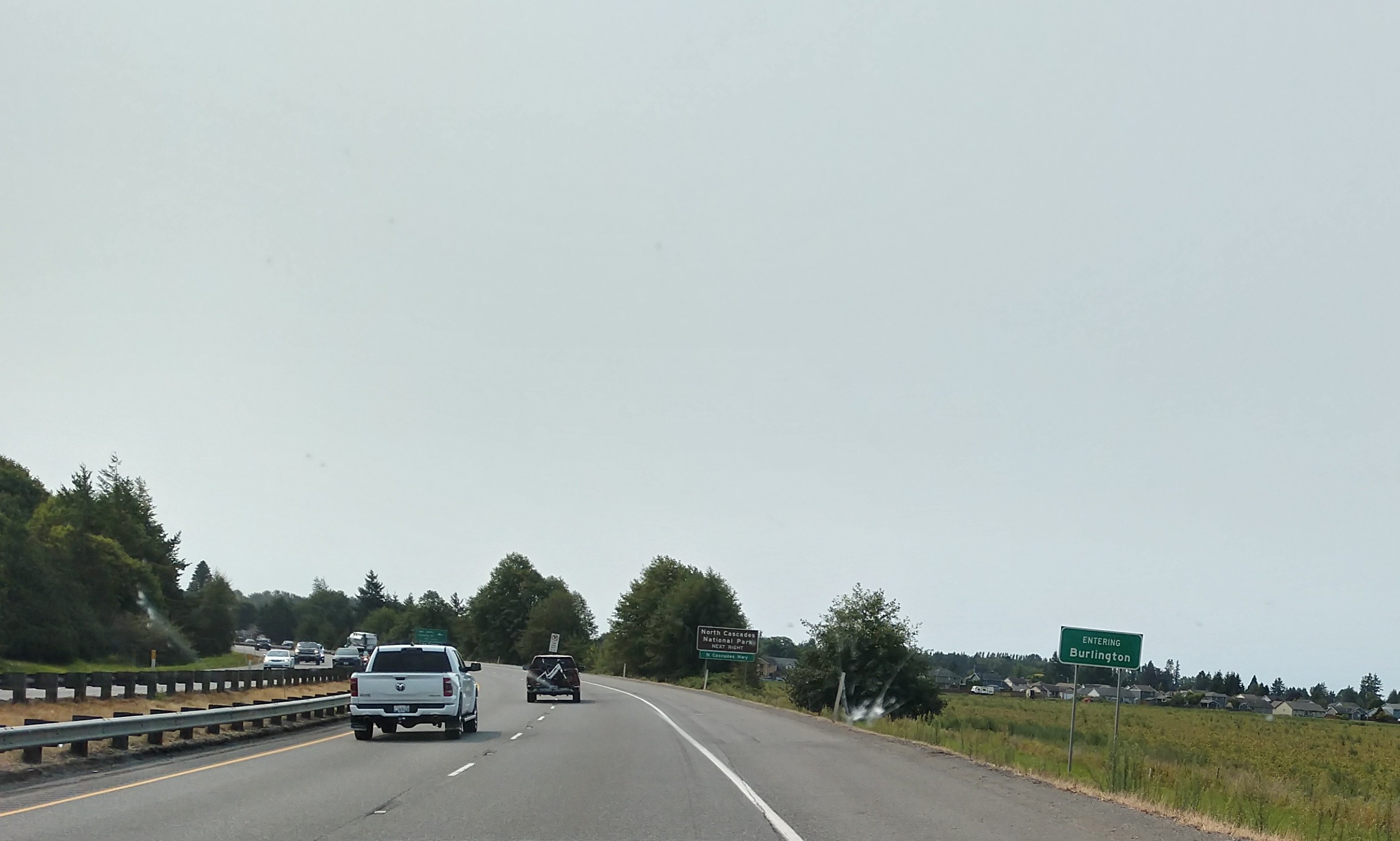
We passed by Burlington, WA. Burlington is a city in Skagit County, Washington. It has a population of 9,152. Burlington is located approximately halfway between Seattle and Vancouver, B.C.
Burlington began as a logging camp, established by John P. Millett and William McKay, in 1882. It was officially incorporated on June 16, 1902. Originally, Burlington's businesses were centered on Fairhaven Avenue. Today, Fairhaven Avenue is the center of Burlington's old downtown, which has since been revitalized.
We turned on to WA Highway 20 West toward Burlington and Anacortes.
Anacortes is now 16 miles away.
We passed the Port of Skagit County Airport.
We then entered a tsanumi hazard zone, and Padilla Bay National Reserve is on the right.
We are now in the La Conner, Washington area.
La Conner is a town in Skagit County, Washington, United States with a population of 965. It is included in the Mount Vernon–Anacortes, Washington Metropolitan Statistical Area. The town hosts several events as part of the annual Skagit Valley Tulip Festival held in April. La Conner was first settled in May 1867 by Alonzo Low and was then known by its post office name, Swinomish. Its location on the Swinomish channel was an ideal safe harbor for ships. In 1869, J.S. Conner bought the settlement's trading post and in 1870 had the name changed to honor his wife, Louisa Ann Conner. The French-appearing "La" represented her first and middle initials. When Skagit County was created out of Whatcom County in 1883, La Conner was chosen as the county seat, but would only hold that designation until November 1884 when the seat was moved to Mount Vernon.
(Sketch of the town of La Conner, Washington, ca 1889.)
Above is part of downtown La Conner, with the Swinomish Channel behind it. Rainbow Bridge at left, fishing port on the Swinomish Reservation across the channel.
Above is La Conner's Rainbow Bridge crossing the Swinomish Channel. La Conner's Rainbow bridge connects La Conner to Fidalgo Island, which includes the gated Shelter Bay Community, the Swinomish reservation, and the city of Anacortes. The center of town—roughly bounded by 2nd, Morris, and Commercial streets and Swinomish Channel—is a historic district, listed on the National Register of Historic Places.
Above is the La Conner, Washington waterfront with Mount Baker (10,781 feet) in the background.


We entered Anacortes. Anacortes is a city in Skagit County, Washington. The name "Anacortes" is an adaptation of the name of Anne Curtis Bowman, who was the wife of early Fidalgo Island settler Amos Bowman. Anacortes has a population of 17,637. Anacortes is known for the Washington State Ferries dock and terminal serving Lopez Island, Shaw Island, Orcas Island, and San Juan Island. There is also a Skagit County-operated ferry that serves Guemes Island, a residential island located across Guemes Channel, north of Anacortes.

Anacortes is within the historical territory of the Samish people. Anacortes was officially incorporated on May 19, 1891. In 1877, railroad surveyor and town founder Amos Bowman moved his family to the northern tip of Fidalgo Island. Bowman began promoting the area as an obvious terminus for the Northern Pacific Railway as it was built through the north Cascades to the Pacific. Bowman established the town's first newspaper, The Northwest Enterprise, to promote his vision of the New York of the West.
Seattle and Northern Company began building a rail line from the town in 1888. Real estate and development boomed from 1888 to 1890 as a result of the railroad rumors, and the Oregon Improvement Company posted $15 million in bonds to develop the town. In 1891, the real estate bubble burst. Speculators lost money and the Oregon Improvement Company could no longer afford to complete tracks over the Cascades. The town failed to become the railroad terminus Bowman had envisioned. After the bust, the town became prominent for its fishing tradition, thriving canning industry, and timber mills.

We then turned off onto Snee-Oosh Road and headed toward the La Conner Thousand Trails.
The La Conner Thousand Trails has 111 acres of camping space and a half-mile of saltwater beachfront. When we arrived at 12:15 p.m., we didn't have a reservation (because we had left Canada earlier than we had originally planned due to the forest fires and heavy smoke). So we asked how many days we could get as we were originally hoping to stay for two weeks (14 days).
At this time, they could get us scheduled for five days, so we drove in and hoped to find just the right spot that was hopefully a full-hookup site. We would check back later to see if they could extend our stay as they promised us that they would keep checking. Good news -- we were able to extend our stay here for another five days. So our total stay at the La Conner Thousand Trails this time was 10 days!
We ended up on site #86, with just electricity and water, as there were no full-hookup sites available.
The map of the La Conner Thousand Trails Campground is shown below. After we got all set up, we decided to drive back toward town.
We entered the territory of the Swinomish Indian Reservation. The Swinomish Reservation is located on Fidalgo Island in Western Washington State. It is the home of the Swinomish Indian Tribal Community, a federally recognized tribe. The Swinomish Tribe is descended from and is a successor to tribes, including Swinomish, Kikiallus, Samish and Lower Skagit, that inhabited the Skagit Valley and Puget Sound islands for thousands of years before non-Indian settlement.
The Swinomish Reservation was established in 1855 by the Treaty of Point Elliott. The Treaty reserved the part of Fidalgo Island which was known at the time as Shais-quihl. Treaty time maps show that the western boundary of the Swinomish Reservation is a north-south line between Fidalgo and Similk bays. The eastern boundary follows what is now known as the Swinomish Channel.
In 1873, President Ulysses S. Grant issued an Executive Order which attempted to unilaterally change the western boundary of the Swinomish Reservation. The United States Supreme Court has repeatedly ruled that only Congress – not a President - can reduce the size of a reservation. This unlawful attempt to take a portion of the Reservation and other violations of the treaty remain a painful part of Swinomish tribal history.
We drove over the bridge across Swinomish Channel. The Swinomish Channel is an 11 mile long salt-water channel in Washington state, which connects Skagit Bay to the south and Padilla Bay to the north, separating Fidalgo Island from mainland Skagit County. The Swinomish Channel is the smallest of the three entrances to Puget Sound—the other two being Deception Pass and Admiralty Inlet.
The Swinomish Channel is partly natural and partly dredged. Before being dredged, it was a collection of shallow tidal sloughs, salt marshes, and mudflats known as Swinomish Slough. The United States Army Corps of Engineers used dredging and diking to create a navigable channel, completed in 1937 during the Great Depression. The channel is heavily used by fishing boats, tugs, recreational craft, and shallow-draft freight vessels. To maintain navigable depths, the Swinomish Channel must be dredged at least every three years.
(View north from La Conner of the Swinomish Channel.)
First, we stopped and got gas at the Swinomish Market & Casino.
Then we went to the Taco Bell in Burlington. It had been a very, very long time since we had seen or been able to eat at a Taco Bell. We were so excited to see the Taco Bell when we first drove through Burlington! (The only bummer was that we had to use the drive through because the inside was closed.)
We then drove through the Bay View State Park. It is a public recreation area located on Padilla Bay in Skagit County, Washington. The state park's 66 acres include 1,285 feet of shoreline and facilities for camping, picnicking, swimming and beachcombing. It originated in 1925 when the Skagit County Agricultural Association donated land to the state to be used for park purposes. The park is crossed by a stretch of the Pacific Northwest Trail.
(View of Padilla Bay from Bayview State Park.)
We then stopped at Camping World in Burlington, and then stopped back at the Swinomish Market & Casino to get some beer and rum before heading back to the campground. We got back around 4:30 p.m.
Mel had been watching for a full-hookup site to open that we could move onto. Well, his patience paid off and even though we would have to re-do everything, it would be worth it to have a full-hookup for the 10 days of our stay. So at 7:00 p.m., we moved to site #311, and were finished setting up at around 8:30 p.m.
Thursday, August 24, 2023
Today started out sunny at 61 degrees, but as the afternoon crept in, so did the smoky conditions. We just ran a couple of errands today -- first stopping at Camping World to return the regulator Mel had bought earliers and then we stopped at Fred Meyer to get a few groceries.
For dinner tonight we had jalapeno poppers as an appetizer, and barbeque ribs and scalloped potatoes.
Friday, August 25, 2023
After a scrumptious breakfast of blackberry waffles (see below), Mel played pickleball at the campground from 9:00 a.m. to 11:00 a.m. Pickleball is a paddle sport in which two or four players hit a perforated, hollow plastic ball with paddles over a 34-inch high net until one side is unable to return the ball or commits an infraction.
Even though today started out a bit cloudy at 59 degrees, it soon turned beautifully sunny and 71 degrees.
Then later in the afternoon around 4:00 p.m., we joined the Canadian pickleball players for happy hour (which consisted of snacks and BYOB)!
Dinner tonight was grilled hamburgers and sweet potato fries.
Saturday, August 26, 2023
What a beautiful day with sunny skies and 59 degrees that would creep quickly to 89 degrees. We left this morning at 8:30 a.m. to go to my childhood friend, Debra (Lienemann) Wise and her husband Don's house in North Bend, Washington.
Our first stop was at the Swinomish Casino in Anacortes, Washington to get gas.
We're now 24 miles from Everett, Washington (which is close to where Debra's sister Kim lives), and 54 miles from Seattle, Washington.
Everett is the county seat and largest city of Snohomish County, Washington. It is 25 miles north of Seattle and is one of the main cities in the metropolitan area and the Puget Sound region. Everett is the seventh-largest city in the state by population, with 110,629 residents. The city is primarily situated on a peninsula at the mouth of the Snohomish River along Port Gardner Bay, an inlet of Possession Sound (itself part of Puget Sound), and extends to the south and west.
The Port Gardner Peninsula has been inhabited by the Snohomish people for thousands of years, who had a winter village named hibulb near the mouth of the river. Modern settlement in the area began with loggers and homesteaders arriving in the 1860s, but plans to build a city were not conceived until 1890. A consortium of East Coast investors seeking to build a major industrial city acquired land in the area and filed a plat for "Everett", which they named in honor of Everett Colby, the son of investor Charles L. Colby. The city was incorporated in 1893, shortly after the arrival of the Great Northern Railway, and prospered as a major lumber center with several large sawmills. Everett became the county seat in 1897 after a dispute with Snohomish contested over several elections and a Supreme Court case.
Everett remains a major employment center for Snohomish County, but has also become a bedroom community for Seattle in recent decades. It is connected to Seattle by Interstate 5 and various public transit services at Everett Station, including the Sounder commuter train, Amtrak, and commuter buses.


We are now 20 miles from Seattle. We follow I-405 South toward Bellevue.
We then follow I-90 East toward Spokane.
We are now near Exit 31, for WA 202 West toward North Bend, Washington.
We're now in North Bend, Washington.

North Bend is a city in King County, Washington on the outskirts of the Seattle metropolitan area. The population was at 7,461 in the 2020 census. Since the closure of Weyerhaeuser's Snoqualmie sawmill, North Bend has become a prosperous bedroom community for Seattle located about 30 miles to the west.
(Aerial view of North Bend with Mount Si.)
The town was made famous by David Lynch's television series Twin Peaks, which was partially filmed in North Bend. The community is also home to Nintendo North Bend, the main North American production facility and distribution center for the video game console manufacturer Nintendo.
The Snoqualmie Indian Tribe has resided in the Snoqualmie Prairie including the area now known as North Bend for thousands of years. This prairie southeast of Snoqualmie Falls was the ancestral home, hunting and forage grounds for the Snoqualmie people and was located in the upper Snoqualmie Valley near the Snoqualmie River fork confluence, Mount Si, and the western foothills of the Cascade Range.

One of the first American explorers to the upper Snoqualmie Valley was Samuel Hancock who arrived in 1851. Hancock traveled upriver with his Snoqualmie guides, fording canoes around the falls to reach Snoqualmie Prairie, and searching for coal deposits. He was taken to a "very extensive and fertile prairie" about two miles above Snoqualmie Falls. The beautiful open grassland came to be known as the Snoqualmie Prairie, the heart of which is now known as Tollgate and Meadowbrook farms.
The Snoqualmies, led by Chief Patkanim, later sided with early settlers in the 1850s Indian Wars and were one of the signatory tribes of the Treaty of Point Elliott in 1855, which failed to designate an Indian reservation for the Snoqualmies. Some of the soldiers in those wars, such as the Kellogg brothers, established cabins near remaining Snoqualmie blockhouses; however, the most well known American resident in the valley was Jeremiah Borst, who arrived in 1858.
(Jeremiah Borst, 1830–1890 was the father of the Snoqualmie Valley community.)
After the Homestead Act of 1862, more settlers ventured to the Snoqualmie Valley, with the first families settling near Borst on the easterly end of Snoqualmie Prairie. In 1865, Matts Peterson homesteaded the site that ultimately became North Bend. In 1879, Peterson sold the property to Borst and moved east of the Cascades. Borst wrote to Will Taylor, who had left the Pacific Northwest to pursue mining in California, and offered him the Peterson homestead in exchange for labor.
(William Taylor, 1853-1941 was the founder of North Bend.)
Taylor returned and became the driving force in developing the town while expanding his property to include a thriving trading post and boarding house for travelers over Snoqualmie Pass. On February 16, 1889, with the upcoming railroad boom, Taylor formally platted a town including his farm, upcoming street plans and building lots, giving it the name "Snoqualmie Prairie". Later that summer, competing Seattle land speculators subsequently platted nearby "Snoqualmie Falls", choosing a similar name. Pressured by demands of the Seattle, Lake Shore and Eastern Railway to avoid confusion, Taylor reluctantly renamed his town "Mountain View". However, the U.S. Post Office Department objected to "Mountain View", as a town with that name already existed in northern Whatcom County.
(Downtown North Bend in 1943.)
To conclude the matter Taylor agreed to permanently rename the community "North Bend", after its prime location near the large northward bend of the South and Middle Fork of the Snoqualmie River. Taylor was proud of his new, thriving town, but by historical accounts, "He never got over having his town name taken away." North Bend was officially incorporated on March 12, 1909, and grew throughout the 20th century, with an early economic focus on logging, sawmill production, agricultural and dairy farming.

We now turned onto SE 149th Place where my friends, Don and Debra Wise, live in North Bend, Washington. We arrive at their house at around 11:00 a.m.
Shown above is the 8th Grade Confirmation Class of Trinity Lutheran Church in Perry, Iowa (ca 1969). In the back row from left to right is Pastor Vern D. Hinz, Brian Hansen, Mike Brelsford, and William Hinz. In the middle row from left to right is Debra (Lienemann) Wise, Diane Vestal, and Shirley (Blaisdell) Mendenhall. In the front row from left to right is Marsha Godwin and Holly Hethcott.
Above is Don and Debra Wise's backyard with the playhouse in the background.
Above is Don and Debra Wise's backyard with Mount Si in the background. Below is a closer view at Mount Si.
(Mount Si in Washington state.)
Mount Si is a mountain in the northwest United States, east of Seattle, Washington. It lies on the western margin of the Cascade Range just above the coastal plains around Puget Sound, and towers over the nearby town of North Bend. Mount Si and neighboring mountain Little Si were named after local homesteader Josiah "Uncle Si" Merritt. The mountain became nationally familiar in the early 1990s with the television series Twin Peaks, which was filmed in North Bend.
Only about a 45-minute drive from Seattle, the mountain is a favorite outdoor destination for residents of Puget Sound. Between 80,000 and 100,000 hikers visit the mountain annually. The four mile Mount Si trail vertically climbs 3,500 feet to the summit ridge. Its summit is reached by an exposed scramble, class 3, up the north side of the summit block, which is known as the "Haystack". Mount Si is a remnant of an oceanic plate volcano and the rocks are highly metamorphosed.
In Snoqualmie culture, Mount Si features prominently in a Prometheus story from the Snoqualmie people. According to Snoqualmie tradition, Mount Si is a fallen body or Moon, who is the paramount god in Snoqualmie traditional religion. Moon had ordered that a rope of cedar bark be stretched between the Earth and the sky. The Coyote and Blue Jay went up the rope, with Blue Jay pecking a hole in the sky for Coyote to crawl through, where he found himself at the bottom of a lake. He transformed into a beaver, but got trapped in a beaver trap set by Moon. Coyote played dead to trick Moon and was brought back to his house, where he was skinned by Moon and his carcass thrown away in the corner, where he waited paitently.
When Moon had fallen asleep, Coyote reapplied his skin and explored the house of Moon, finding great forests, fire, the sun, and a contraption that made daylight among his possessions. Coyote then stole them, transforming back to his regular form and descending back down the rope to distribute what he had stolen across the earth. Awakening to find his possessions stolen, Moon chased Coyote down the cedar rope in anger, but it broke and he fell to his death, forming the mountain. Moon's face is visible on the rocks near the summit.

Following are more pictures from the backyard of Don and Debra Wise's house in North Bend.
Shown below is Kim (Lienemann) Royer and her sister Debra (Lienemann) Wise in front of the dining room table inside the house.
Below is a picture of Kim (Lienemann) Royer and her sister Debra (Lienemann) Wise.
Above is a picture of Kim (Lienemann) Royer and her sister Debra (Lienemann) Wise seated in the front and Don Wise behind them.
Above is a picture of Shirley Mendenhall with her friend, Debra (Lienemann) Wise seated in front, with Debra's sister Kim (Lienemann) Royer standing behind.
Don and Debra Wise had us stay for lunch. They prepared a very delicious meal of grilled steaks, baked potatoes, a spinach salad with strawberries and a vinaigrette dressing, sliced tomatoes from their garden with ranch dressing, sweet corn, zucchini bread, and a wonderful dessert of white chocolate panna cotta (see below).
Above is Debra Wise with her wolf cut-out in her front garden area.
Above and below, Mel discusses the Wise house and property with Don Wise. We left their house at about 5:30 p.m. It was a wonderful day!
On the way back, we got another look at Mount Si in North Bend, Washington.
Above and below are a couple pictures of the Seattle skyline as we drive by on our way back to the La Conner Thousand Trail Campground.
And then about 7:30 p.m. as we were just nearing La Conner, there was a fabulous sunset!
Sunday, August 27, 2023
It was sunny and 63 degrees this morning and it reached 81 degrees by the afternoon. Mel went to play pickleball again this morning from 9:00 a.m. to 11:00 a.m.
And in the afternoon, we went to happy hour from 4:00 p.m. to 6:00 p.m. For dinner tonight, we had grilled chicken drummies, zucchini spears and leftover scalloped potatoes.
At 7:30 p.m., we went to the trail of one of the Canadians to listen to three guys play their guitars (see pictures below).


.jpg)


.jpg)
_founder_of_North_Bend.jpg)


No comments:
Post a Comment