* * * * * * * * * *
This blog post summarizes our " Favorite Things " or the '' The Best of the Best " during our travels this summer in Alaska and Canada !
We started our trip on Monday, April 10, 2023 leaving from Matheson, Colorado. Our last day in Canada was August 21, 2023. We were gone from the lower 48 states for 134 days!
On the way to Alaska, we traveled through the states of Colorado, Wyoming, Montana, and Alaska, then through the provinces of Alberta and British Columbia and into the territory of Yukon in Canada, until we finally arrived back in Washington state in the United States.
Each of the unique license plates below are from areas we traveled to this summer:
(Colorado -- The Colorful Colorado State)
(Wyoming -- The Cowboy State)
(Montana -- Big Sky Country)

(Province of Alberta -- Wild Rose Country)

(Province of British Columbia -- Beautiful British Columbia)

(Yukon Territory -- The Klondike)

(Alaska -- The Last Frontier State)
(Washington -- The Evergreen State)
* * * * * * * * * *
We crossed the border many times from the United States into Canada and then back into the United States again at the following border crossings:
* Sweet Grass-Coutts Border Crossing that connects the town of Sweet Grass, Montana with the village of Coutts, Alberta.
* Dalton Cache–Pleasant Camp Border Crossing that connects the towns of Haines Junction, Yukon Territory with Haines, Alaska (we crossed twice -- on way to Haines, Alaska and on return trip out of Haines, Alaska back to Haines Junction, Yukon Territory).
* Alcan–Beaver Creek Border Crossing that connects the towns of Tok, Alaska and Beaver Creek, Yukon Territory.
* Poker Creek–Little Gold Creek Border Crossing located on the Top of the World Highway that connects the communities of Chicken, Alaska and Dawson City, Yukon Territory and is the northernmost international border crossing in North America.
* Skagway–Fraser Border Crossing that connects the communities of Skagway, Alaska and Carcross, Yukon Territory (we crossed twice -- on way to Skagway and on return trip out of Skagway).
* Hyder–Stewart Border Crossing that connects the communities of Hyder, Alaska, and Stewart, British Columbia (there was no border crossing going into Hyder, Alaska; just one when you go back out of Hyder, Alaska).
* Sumas–Abbotsford (Huntingdon) Washington Border Crossing that connects the cities of Sumas, Washington, and Abbotsford, British Columbia.
* * * * * * * * * *
I found a neat drab gray-colored rock along our trip -- and it serves as a physical reminder of our 'once-in-a-lifetime' trip to Alaska and back. There are several belts or rings of white on the front and back of the rock. The rings on the rock are representative of all the different roads or highways we crossed throughout Alaska and Canada this summer. In fact, we drove 12,240 miles and crossed many roads in the 134 days we were gone.

The rock is known as a 'wishing rock' because it is a magical rock that can often be found along the seashore that has a white quartz ring on it somewhere. To be magical, the ring must be complete and encircling the entire rock. The ring can be singular, or crossed by other rings, as long as there is one complete ring -- the legend says that the magic will work.
It has been believed for centuries that if you make a wish for yourself upon the 'wishing rock' -- your wish is said to come true. And if you make a wish on it for someone else, or pass the 'wishing rock' to a friend, then their wish and all of your wishes are said to come true, too!
Popular lore indicates that if you make your wish while tracing the white quartz line on the 'wishing rock' with your finger at the same time, this will enhance the chance of your wish coming true. You can keep the small 'wishing rock' in your pocket, or place it close to where you sit or sleep! Larger rocks can also be placed near the entrance to your home inviting your wishes to come true.
But what really are these tell-tale white stripes on the 'wishing rocks'? The bands of white are called veins, and are either quartz or mineral calcite that has filled the rock’s fissures or cracks. The calcite was formed from the precipitation of calcium carbonate when water ran over and through the rocks with powerful compression forces that drove it into the mineral calcite.
Interesting, huh? I'm wishing that Mel and my voyages throughout life will always be blessed -- with exciting things to see and do and friends to meet along the way!
* * * * * * * * * *
But how can someone truly describe a journey to Alaska? That in itself, would be an enormous task -- but I will give it a try . . .
President Dwight D. Eisenhower signed the official proclamation admitting Alaska as the 49th state on January 3, 1959. Alaska is a non-contiguous U.S. state on the northwest extremity of North America bordering the province of British Columbia and the Yukon Territory in Canada to the east and sharing a western maritime border in the Bering Strait with Russia. The name "Alaska" is derived from the Aleut "alaxsxaq" meaning "the mainland" or literally "the object towards which the action of the sea is directed".
When looking at Alaska's land size there is much to be said. First of all, Alaska has more than 57 million acres of designated wilderness that is full of wildlife galore (see our tally below of how many different animals we saw on our adventure)! Secondly, Alaska has a total population of 736,081 and an area of 638,268 square miles. Alaska's area would encompass 2-1/2 times the state of Texas; while 1/3 of Alaska's land falls in the Arctic Circle. Thirdly, Alaska's official animal is the moose; dog mushing is Alaska's official sport; and Alaska has the largest fishing industry in the United States.
Alaska was completely mind-blowing for us! There were numerous times that Mel and I both simply stood there in complete awe of the magnificent scenery that surrounded us! For sure, Alaska was truly breathtaking! There were so many beautiful glaciers, magnificent waterfalls and numerous jagged, spectacular snow-covered mountains -- and let's not forget lots and lots of road construction! Our memories will live on forever!
(Map of the highways in Alaska)
We drove most of or a portion of each of the following 15 different highways I have listed on our 12,240 mile journey (to be discussed in more detail below):
1. We drove almost the entire length of the Alaska Highway from mile zero at Dawson Creek, British Columbia to where it ends at Delta Junction, Alaska at milepost 1422. The Alaska Highway is 1,382 miles long. It was originally a 1,422 mile long drive to Alaska, but due to highway construction and rerouting, it is now 40 miles shorter. The Alaska Highway was originally constructed during World War II as a supply route as well as a connection to the lower 48 states.
(Shown above in yellow is the Alaska Highway from Dawson Creek, British Columbia to Delta Junction, Alaska.)
2. We drove several sections of the Klondike Highway. It is a 445 mile highway that connects Skagway, Alaska to Whitehorse and Dawson City in the Yukon Territory. Beginning in Skagway, the South Klondike Highway climbs steeply for 14 miles to the 3,292 foot summit of the White Pass near the Alaska/Canada border. The Klondike Highway roughly parallels the route taken by the prospectors in the heart of the Klondike Gold Rush in 1898.
(Shown above in red is the Klondike Highway that traveled from Dawson City, Yukon Territory to Skagway, Alaska.)
3. We drove most of the Cassiar Highway (Hwy 37). It is a 450 mile long road which provides an excellent alternate route for visitors traveling to or from the Yukon Territory or Alaska. The Cassiar Highway knives its way through the mountain-river-lake-glacier country. With several communities enroute, we allowed time for a side-trip to the neighboring towns of Stewart, British Columbia and Hyder, Alaska that can only be reached by the 40 mile (Hwy 37A). This side-trip highway opened up some of the North’s most spectacular glacier and mountain scenery. This area of British Columbia and Alaska was absolutely one of the most beautiful areas we visited on our trip north!
(Shown above in red is the Cassiar Highway that runs from the northern British Columbia border to Kitwanga Junction, British Columbia.)
4. The Top of the World Highway is really two highways. In the Yukon, the Top of the World Highway is the Yukon Hwy 9, while in Alaska, the Top of the World Highway is the Taylor Highway. The Taylor Highway runs from the Alaska Highway all the way to Eagle, Alaska. This road winds its way along the top of a mountain range providing a unique scenic drive with exhilarating views. The length of the Top of the World Highway is 175 miles.
(Shown above in red is the Top of the World Highway that runs from Dawson City, Yukon Territory to the Alaska Highway at the Tetlin Junction in Alaska.)
5. We traveled a portion of the Yellowhead Highway, which officially starts in Massett, on Haida Gwaii (formerly known as Queen Charlotte Islands) and includes the ferry crossing from Skidegate to Prince Rupert. From Prince Rupert, the Yellowhead Highway route crosses the western provinces of British Columbia, Alberta and Saskatchewan before officially ending in Winnipeg, Manitoba. The entire length is along Highway 16 and is part of the Trans-Canada Highway System.
(Shown above in red is a section of the Yellowhead Highway that we traveled along, which was 455 miles. It goes from Prince George in the center of British Columbia to Prince Rupert on British Columbia’s Pacific coast. Prince Rupert is the terminus for two coastal ferry Systems – The Alaska Marine Highway System and the British Columbia Ferry System.
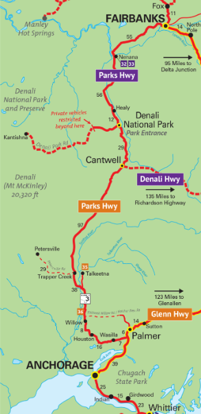
6. We drove along the entire length of the Parks Highway. This highway paralleled the Alaska Railroad and traveled through 358 miles of Alaska’s most rugged terrain from Anchorage to Fairbanks, crossing over 40 bridges. The Parks Highway connected us to the Denali National Park, where we found "The Great One" or Mount McKinley -- North America’s tallest mountain. The name Denali translates to “The Great One” and seems very appropriate for the 20,310-foot mountain.
(Shown above in red is the Parks Highway that goes from Anchorage to Fairbanks, Alaska.)
7. We drove the entire length of the Seward Highway. It is 127 miles long and has been designated a National Forest Scenic Byway. This highway runs along the Turnagain Arm through the scenic Kenai Peninsula. It connects the city of Anchorage to Seward traveling past salt water bays, ice-blue glaciers, and alpine valleys. Most of the Seward Highway passes through the Kenai Mountains-Turnagain Arm National Heritage Area that stretches from Girdwood to Seward and includes Whittier, Portage, Hope and Cooper Landing in Alaska.
(Shown above in red is the Seward Highway that connects the cities of Anchorage to Seward in Alaska.)
8. We drove the majority of the Glenn Highway that runs between Anchorage and Glennallen in Alaska. The highway is 189 miles long and is entirely paved. The Glenn Highway passes alongside the Mentasta and Wrangell mountain ranges and crosses the fertile farm lands of the Matanuska Valley (Mat-Su).
(Shown above in red is the Glenn Highway that connects Anchorage and Glennallen in Alaska.)
9. We drove the entire length of the Sterling Highway, that ran along the western edge of the Kenai Peninsula and featured extraordinary mountain scenery, sparkling lakes, glacier-fed streams, and beautiful coastal inlets. Wildlife abounded along this scenic route. The highway began at mile 37 of the Seward Highway and traveled 142 miles to Homer at the southwest end of the Kenai Peninsula. The Sterling Highway accessed the towns of Cooper Landing, Sterling, Soldotna, Kenai, Clam Gulch, Ninilchik, Anchor Point, and Homer in Alaska.
(Shown above in red is the Sterling Highway that runs from Homer all the way north to just after Cooper Landing in Alaska.)
10. The Tok Cutoff Highway took us to Tok, Alaska. Tok is often referred to as the “Gateway to Alaska,” because it is one of the first major communities in Alaska that you come to when heading north. The highway is 125 miles long.
(Shown above in red -- in the middle right side of the map -- is the Tok Cutoff Highway that runs from Slana to Tok in Alaska.)
11. We drove a portion of the Denali Highway, which is a scenic 135 mile route from Paxson to Cantwell in Alaska. It begins at the Richardson Highway and ends at the Parks Highway, 27 miles south of the Denali National Park entrance. Paxson Junction is at mile 177 of the Richardson Highway. Cantwell Junction is at mile 210 of the Parks Highway. The Denali Highway was constructed in 1957 as the only route to the Denali National Park and Preserve.
(Shown above in red is the Denali Highway that runs from Paxson to Cantwell in Alaska.)
12. We drove the entire Haines Highway. It is one of the most spectacular drives in the North. It is a National Scenic Byway and when you drive it you will understand why. The Highway is 153 miles long and it essentially follows the trail used by the Chilkat/ Tinglit First Nations who traded with the Athabascan First Nations in the interior of the Yukon Territory. It was originally called the “Grease Trail” as the main commodity was oil from the candle fish found in the ocean near Haines, Alaska. In the late 1800s, the trail was improved by Jack Dalton, an explorer and white trader, who recognized the importance of the route and established several Trading Posts.
(Shown above in red is the Haines Highway that runs from Haines, Alaska to Haines Junction, Yukon Territory.)
13. We drove only a small portion of the Steece Highway in the Fox area. It is a highway in the Interior Region of the Alaska that extends 161 miles from Fairbanks, Alaska to Circle, a town on the Yukon River about 50 miles south of the Arctic Circle. The highway was completed in 1927 and is named for U.S. Army General James G. Steese, a former president of the Alaska Road Commission.
(Shown above in yellow is the Steece Highway that runs from north of Fairbanks at Fox to Circle in Alaska.)
14. We drove only a little way up the Dempster Highway just past Dawson City and not all the way to the Tombstone Territorial Park because of the wildfires and smoke that were occuring there. The highway was completed in 1979. It is a maintained gravel and crushed stone road which extends 461 miles to Inuvik, an Inuit village 202 miles above the Arctic Circle in the Northwest Territories. The Dempster Highway starts 25 miles east of Dawson City, Yukon Territory and 308 miles north of Whitehorse, Yukon Territory. It is 486 miles from Dawson City, Yukon Territory to Inuvik, Northwest Territory.
(Shown above in gold is the Dempster Highway that starts just east of Dawson City in the Yukon Territory and heads north to Inuvik and Tuktoyaktuk in the Northwest Territory.)
15. We drove the entire length of the Richardson Highway. It was originally called the "Valdez to Eagle Trail". It is Alaska’s oldest highway (built in 1910) and the only highway that connects Fairbanks to Valdez, Alaska. Valdez is at mile 0 of the Richardson Highway and Fairbanks is at mile 364. The drive took us through the spectacular and narrow Keystone Canyon and across the Thompson Pass where we found Worthington Glacier, one of the few glaciers in the world that we could drive to.
(Shown above in red is the Richardson Highway that runs from Fairbanks to Valdez, Alaska.)
* * * * * * * * * *
We kept our eyes open for the wildlife in Alaska and Canada -- from eagles, whales, moose, grizzly, black bears, and much more. Our Wildlife Count in Alaska and Canada was totally amazing with Alaska abounding with wildlife on land and in the water! The top ten wildlife that we counted the most of include: 1) Wood Buffalos; 2) Stellar Sea Lions; 3) Bighorn Sheep; 4) Trumpeter Swans; 5) Moose; 6) Musk Oxen; 7) Deer; 8) Seagulls; 9) Elk; and 10) Bald Eagles. See our specific counts below:
LAND ANIMALS
98 Wood Buffalos
43 Bighorn Sheep
36 Moose
36 Musk Oxen
33 Deer
26 Elk
23 Reindeer
15 Black Bears
11 Dall Sheep
9 Brown Grizzly Bears
8 Caribou
8 Porcupines
8 Marmots
6 Mountain Goats
2 Squirrels
2 Beavers
2 Gray Foxes
1 Red Fox
1 Coyote
1 Rabbit
MARINE MAMMALS
50 Stellar Sea Lions
20 Harbor Seals
5 Sea Otters
3 Orca Whales
3 Baby Humpback Whales
2 Finn Whales
DUCKS, GEESE & SWANS
39 Trumpeter Swans
20 Mallad Ducks
17 Canadian Geese
SEABIRDS
32 Seagulls
8 Puffins
BIRDS OF PREY
24 Bald Eagles
LAND BIRDS
8 Ptarmigan
1 Woodpecker
WADING & SHOREBIRDS
2 Sandhill Cranes
2 Blue Herons
FISH & AMPHIBIANS
We saw lots of Salmon -- too many to count -- especially at the Bear Creek Weir in Seward, Alaska and the Fish Creek Wildlife Observation Site in Hyder, Alaska.
MARINE INVERTEBRATES
We saw lots of Sea Urchins including anemones, mollusks, sea stars and hermit crabs -- too many to count -- especially at the Alaska SeaLife Center in Seward, Alaska and on our full-day Peterson Bay Field Station & Center for Alaskan Coastal Studies in Kachemak Bay across from Homer, Alaska.
Overall, we saw more than 35 different wildlife species and therefore earned the following certificate (see below).
* * * * * * * * * *
And for the rest of this blog, I'm going to list "My Favorite Things". And, just like in the lyrics of the song from "The Sound of Music" -- and when I'm feeling sad -- I simply remember my favorite things, and then I don't feel so bad. I actually feel happy and very exhilarated recalling all my favorite things from our journey to Alaska!!!
Favorite Campgrounds:
* Liard River Hot Springs Provincial Park Campground in Liard River, British Columbia (shown above)
* Lake Louise Campground in Bannf, Alberta
* Pine Lake Campground in Haines Junction, Yukon Territory
* Haines Hitch-Up RV Park in Haines, Alaska
* Chena RV Park in Valdez, Alaska
* Matanuska River Park in Palmer, Alaska
* All Seasons Campground in Ninilchik, Alaska
* JJK Campsites in Seward, Alaska
* Teklanika River Campground & Riley Creek Campground in Denali National Park
* Tanana Valley Campground in Fairbanks, Alaska
* Bonanza Gold Motel & RV Park in Dawson City, Yukon Territory
* Wolf Creek Campground in Whitehorse, Yukon Territory
* Garden City RV Park in Skagway, Alaska
* Downtown RV Park in Watson Lake, Yukon Territory
* Red Goat Lodge Campground in Iskut, British Columbia
* Rainey Creek Municipal Campground in Stewart, British Columbia
* Camp Run-A-Muck in Hyder, Alaska
* Wild Rose Campground in Hope, British Columbia
Favorite Boondocking Sites:
* Base Camp in Kennecott, Alaska (shown above)
* Roadside @ Destruction Bay
* Roadside @ Slana River Bridge area
* Copper River Campground in Chitina, Alaska
* Denali Viewpoint North Campground
* Downtown Chicken in Chicken, Alaska
Favorite Glaciers:
* Salmon Glacier in Hyder, Alaska (shown above)
* Athabasca Glacier in the Columbia Icefield of the Canadian Rockies
* Kennicott Glacier & Root Glacier in Kennecott, Alaska
* Worthington Glacier & Valdez Glacier in the Valdez, Alaska area
* Matanuska Glacier in Alaska's Mat-Su Valley
* Portage Glacier in the Girdwood, Alaska area
* Bear Glacier, Holgate Glacier & Aialik Glacier in Kenai Fjords National Park
* Bear Glacier on way to Stewart, British Columbia
* Berendon Glacier in Hyder, Alaska
Favorite Waterfalls:
* Million Dollar Falls in Haines Junction, Yukon Territory (shown above)
* Bow Falls in Bannf, Alberta
* Horsetail Falls & Bridal Veil Falls in Keystone Canyon near Valdez, Alaska
* Barbara Falls & Thunder Bird Falls in Eagle River, Alaska
* Lowell Point Road Falls, a man-made waterfall in Seward, Alaska
* Lower Reid Falls in the Gold Rush Cemetery; Pitchfork Falls & Bridal Veil Falls in Skagway, Alaska
Favorite Scenic Drives:
* Drive along the Kenai Peninsula in Alaska (shown above)
* Drive into Valdez, Alaska to Thompson Pass and through Keystone Canyon
* Seward Highway and the Cook Inlet on the way to Anchorage, Alaska
* Drive to Homer and Homer Spit in Alaska
* Drive to Hatcher Pass and Independence Mine State Historical Park in Alaska
* Canyon drive along Parks Highway outside of Denali National Park
Favorite Cemeteries:
* Gold Rush Cemetery in Skagway, Alaska (shown above)
* Slide Cemetery in Dyea, Alaska
Favorite Hikes or Bike Rides:
* Rock Glacier Trail in Destruction Bay, Yukon Territory (shown above)
* Rail to Trail & Platte River Bike Trail in Casper, Wyoming
* Millennium Trail in Whitehorse, Yukon Territory
* Soldier's Summit Trail in Kluane National Park and Reserve
* Fort William H. Seward in Haines, Alaska
* Battery Point trailhead in Chilkat State Park in Haines, Alaska
* Kennecott Mines National Historic Landmark Walking Tour in Kennecott, Alaska
* Edge Nature Trail at Matanuska Glacier
* Rodak Nature Trail in Eagle River, Alaska
* Harding Icefield in Seward, Alaska
* Bike Ride from Teklanika Campground in Denali National Park to East Fork River Bridge and back
* Teklanika River walk from our campsite in Teklanika Campground
* Savage River Loop trail, Mountain Vista Trail, Savage Cabin Trail, Triple Lakes Trail, McKinley Station Trail, and the Horseshoe Lake Trail at Denali National Park
* Estuary boardwalk in Stewart, British Columbia
Favorite Self-Guided Walking Tours:
* Skagway, Alaska (shown above)
* Dawson Creek, British Columbia
* Haines Junction, Yukon Territory
* Burwash Landing, Yukon Territory
* McCarthy, Alaska
* Old Town Kenai, Alaska
* Seward, Alaska
* Talkeetna, Alaska
* Nenana, Alaska
* Fairbanks, Alaska
* Dawson City, Yukon Territory
* Dyea Townsite, Alaska (ghost town)
* Carcross, Yukon Territory
* Stewart, British Columbia
Favorite Lakes & Rivers:
* Emerald Lake on way to Skagway, Alaska (shown above)
* Kathleen Lake, south of Haines Junction, Yukon Territory within Kluane National Park
* Kluane Lake in the Yukon Territory
* Nenana and Tanana Rivers in Fairbanks and Anchorage, Alaska area
* Yukon River in Dawson City, Yukon Territory
* Bonanza Creek in Dawson City, Yukon Territory
* Klondike River in the Yukon Territory
* Five Finger Rapids Recreation Site in the Yukon Territory
* Lake Laberge located north of White Horse, Yukon Territory
* Chilkat River in Haines, Alaska
* Tutshi Lake on way to Skagway, Alaska
* Skagway River in Skagway, Alaska
* Bennett Lake in Carcross, Yukon Territory
* Teslin River in Yukon Territory
* Boya Lake, Dease River and Stikine River in British Columbia
* Eddontenajon Lake in Iskut, British Columbia
* Strohn Lake on way to Stewart, British Columbia
* Salmon River and Moose Pond in Hyder, Alaska
* Fraser River in Prince George, British Columbia area
Favorite Churches:
* Church of Saint Nicholas in Nikolaevsk, Alaska (shown above)
* Log Chapel on the Hill in Copper Center, Alaska
* Saint John Orthodox Cathedral in Eagle River, Alaska
* Chapel of St. Nicholas in Kenai, Alaska
* Holy Assumption of Saint Mary Russian Orthodox Church in Kenai, Alaska
* Holy Transfiguration of Our Lord Russian Orthodox Church in Ninilchik, Alaska
* Saint Peter's Episcopal Church in Seward, Alaska
* St. Mark's Episcopal Church in Nenana, Alaska
* Birch Leaf Chapel in Ester, Alaska
* Immaculate Conception Church in Fairbanks, Alaska
* St. Mary's Rectory and Catholic Church, St. Paul’s Anglican Church and St. Andrew's Church in Dawson City, Yukon Territory
* First Presbyterian Church in Skagway, Alaska
* St. John Baptist Church in Carcross, Yukon Territory
* St. Marks Community Church in Stewart, British Columbia
Favorite Bridges:
* Historic Wooden Kiskatinaw Curved River Bridge in Dawson Creek, British Columbia (shown above)
* Canyon Creek Historic Bridge in Haines Junction, Yukon Territory
* Kuskulana Bridge in Chitina, Alaska
* Gilahina Railroad Trestle Bridge in Chitina, Alaska
* Hurricane Gulch Bridge in Cantwell, Alaska
* Shirley Demientieff Memorial Bridge & Mears Memorial Bridge in Nenana, Alaska
* Riley Creek Bridge (aka Alaska Railroad Trestle) in Denali National Park
* Johnson River Bridge on the Alaska Highway
* Yukon Suspension Bridge on way to Skagway, Alaska
* William Moore Cabled Suspension Bridge in Skagway, Alaska
* White Pass & Yukon Route Swinging Bridge located between Nares River & Bennett Lake in Carcross, Yukon Territory
Favorite Towns:
* Talkeetna, Alaska (a historic town) (shown above)
* Fort Macleod, Alberta (a historic town)
* Sexsmith, Alberta (a historic town)
* Dawson Creek, Alberta (located at mile zero on the Alaska Highway)
* Haines, Alaska (a beautiful harbor with totem poles)
* Valdez, Alaska (a beautiful harbor, a historic Old Valdez townsite)
* Whittier, Alaska (a beautiful harbor and the Anton Anderson Memorial Tunnel)
* Homer/Homer Spit (a beautiful harbor)
* Hope, Alaska (a historic little town, a beautiful harbor)
* Ester, Alaska (a quaint, historical town)
* Fairbanks, Alaska (the world's farthest north antler arch)
* Delta Junction, Alaska (a historic little town)
* Chicken, Alaska (a quirky little town)
* Dawson City, Yukon Territory (the George Black Ferry crossing and historic buildings)
* Skagway, Alaska (historic buildings and a beautiful harbor)
Favorite Wood Carvings:
* Whispering Giant in Valdez, Alaska (shown above)
* Sea Goddess, Stunning Mermaid, Eternity, Kraken of Cape Hinchinbrook and the Mosasaur in Valdez, Alaska
* Eagle carving on top of a carving of President Warren G. Harding in Nenana, Alaska
* Cottonwood bark carvings by Rick Jensen in Stewart, British Columbia
* Chainsaw Carving in Hope, British Columbia
Favorite National Parks:
* Kenai Fjords National Park (shown above is a glacier calving)
* Bannf National Park
* S.S. Klondike National Historic Site
* Kluane National Park & Reserve in the Yukon Territory
* Wrangell-St. Elias National Park and Preserve
* Kennecott Mines National Historic Landmark
* Independence Mine State Historical Park
* Klondike Gold Rush National Historical Park
* Denali National Park and Preserve
(National Parks in Alaska)
Favorite Craft Breweries:
* 49th State Brewing in Healy, Alaska (shown above)
* Matanuska Brewery in Palmer, Alaska
* Arkose Brewery in Palmer, Alaska
* 49th State Brewing Company in Anchorage, Alaska
* Kenai River Brewing Company in Soldotna, Alaska
* Homer Brewing Company in Homer, Alaska
* Seward Brewery & Stoney Creek Brew House in Seward, Alaska
* Denali Brewery in Talkeetna, Alaska
* Black Spruce Brewing Company, HooDoo Brewing Company and Lat65 Brewing Company in Fairbanks, Alaska
* Silver Gulch Brewery in Fox, Alaska
* Big Delta Brewing Company in Delta Junction, Alaska
* Yukon Brewing in Whitehorse, Yukon Territory
* Skagway Brewing Company & Klondike Brewing Company in Skagway, Alaska
Favorite Unique Bars:
* Salty Dawg Saloon in Homer, Alaska (shown above)
* Malamute Saloon in Ester, Alaska
* Chicken Creek Saloon in Chicken, Alaska
* The Snake Pit Tavern at The Westminster Hotel in Dawson City, Yukon Territory
* Diamond Tooth Gerties & Sourdough Saloon in Dawson City, Yukon Territory
* Red Onion Saloon & Happy Endings Saloon in Skagway, Alaska
* Glacier Inn in Hyder, Alaska
Favorite Foods & Appetizers:
* Poutine at The Canadian Brewhouse in Lethbridge, Alberta (shown above)
* Bucket of Goodies appetizer for $4.99 at Senators Steakhouse in Cheyenne, Wyoming
* Wild Wing Wednesday at Rockwells Pub Club in Dawson Creek, British Columbia
* Cinnamon Bun at Tetsa River Lodge in British Columbia
* Spinach Bread at Spinach Bread Foodtruck in Talkeetna, Alaska
* Classic Crunch Wrap at Nat Shack in Valdez, Alaska
* All American Burger; French Dip Sandwich & Spicy Burger at Matanuska Brewery in Palmer, Alaska
* Fish and Chips & Clam Chowder at Swiftwater Seafood Cafe in Whittier, Alaska
* Tater Tots with Chicken Alfredo Sauce at Kenai River Brewing Company in Soldotna, Alaska
* Calamari Strips at Chair 5 Restaurant in Girdwood, Alaska
* Rowdy Cowboy Pizza & Chili at Denali Brewing in Talkeetna, Alaska
* Southern Smoked Wings in Alaska BBQ sauce, Smoked & Baked Pizza & Pollo Hermano Pizza at Panorama Pizza Pub in the Healy, Alaska
* All You Can Eat BBQ Dinner & "Music of Denali" Musical Comedy in Denali, Alaska
* Baked Tomato Soup, Alaskan Elk Meat Sandwich & Chicken Parmigiana Sandwich at Prospector's Pizzeria in Denali Boardwalk area
* Mt. Magnificent Burger at 49th State Brewery in Healy, Alaska
* Potato Wedges with Parmesan Cheese & Ranch Dressing; Reuben Rolls at Silver Gulch Brewery in Fox, Alaska
* Bison Chili & Chicken Sue's Famous Chicken Pot Pie at Downtown Chicken in Chicken, Alaska
* Cod Fish and Chips & Fried Chicken Dinner at Sourdough Joe's in Dawson City, Yukon Territory
* Cinnamon Bun at the Braeburn Lodge on the Klondike Highway
* Street Tacos at Bonanza Bar & Grill in Skagway, Alaska
Favorite Best Overall Experiences:
* Head Smashed In Buffalo Jump World Heritage Site in Fort MacLeod, Alberta (shown above)
* Major Marine Kenai Fjords National Park All-Day Cruise in Seward, Alaska
* McCarthy & Kennecott Mines at Wrangell-St. Elias National Park & Preserve
* Liard Hot Springs (the 2nd largest hot springs in Canada)
* World-renowned Sign Post Forest Historic Site in Watson Lake, Yukon Territory
* Alpine Historical Park in Sutton, Alaska
* Independence Mine State Historical Park in Palmer, Alaska
* Portage Glacier Cruise on the Mv Ptarmigan in Girdwood, Alaska
* Bore Tide at Turnagain Arm
* Peterson Bay Full Day Field Station & Center for Alaskan Coastal Studies in Kachemak Bay (across from Homer, Alaska)
* Trans-Alaska Pipeline (Alyeska Pipeline) that runs from Prudhoe Bay to Valdez, Alaska
* Sable Pass & seeing “The Great One” at Denali National Park
* Bear Creek Salmon Weir in Seward, Alaska
* Sternwheeler Riverboat Discovery III Cruise down the Chena River & visit to Chena Athabascan Village in Fairbanks, Alaska
* Pioneer Park in Fairbanks, Alaska
* Gold Dredge No. 8 Tour in Fairbanks, Alaska
* Santa Claus at the North Pole, Alaska
* Chena Hot Springs Resort in Fairbanks, Alaska area
* Sullivan & Rika's Roadhouses in Delta Junction, Alaska
* Diamond Tooth Gerties (saloon with 3 shows per night) in Dawson City, Yukon Territory
* S.S. Keno Sternwheeler Tour in Dawson City, Yukon Territory
* Carcross Desert in Carcross, Yukon Territory
* Jade City in British Columbia
* Stewart Museum in Stewart, British Columbia
* Fish Creek Observation Site in Hyder, Alaska
And finally we truly enjoyed the "Midnight Sun" which is a natural phenomenon that occurs in the summer months in places north of the Arctic Circle or south of the Antarctic Circle, when the Sun remains visible at the local midnight. When the midnight sun is seen in the Arctic, the Sun appears to move from left to right. In Antarctica, the equivalent apparent motion is from right to left. This occurs at latitudes from 65°44' to 90° north or south, and does not stop exactly at the Arctic Circle or the Antarctic Circle, due to refraction.
We even had to put an aluminum foil sunblock window insulation on our trailer windows so we could get a few hours of shut eye during the extra long days of sunlight while we were in Alaska. It was simply amazing that at midnight the sun was still high in the sky.
And these will remain our memories of our favorite things!
Shirley & Mel


.jpg)


I love this. And all the license plates. Wow. I enjoyed the photo of Mel under brewery sign. So cute. ❤️ what a great adventure you've had. I enjoyed it all. 😊 for sharing.
ReplyDelete