Sunday, August 6, 2023
We got up and were rolling down the road at 9:00 a.m. It was a sunny day with a temperature of 54 degrees that would reach 77 degrees by the afternoon.

I just had to have one more look at the beautiful lake at Red Goat Lodge campground (see below) before we left this morning.


And we're off on our way to Stewart, British Columbia with 294 km (or 183 miles) to go.


We just passed the Kinaskan Lake turnoff. There are so many provincial parks in British Columbia. In the picture below, we can see part of the lake.


And just ahead is the turnoff for the Kinaskan Lake Provincial Park. Kinaskan Lake Park was established on December 4, 1987. Located at the south end of Kinaskan Lake between the Skeena and Coast Mountain Ranges, this park offers spectacular scenery and good rainbow trout fishing. The Iskut River runs through the park to the south, where it enters Natadesleen Lake. The Little Iskut River branches off to the west into Mount Edziza Park. Special features in this park include Cascade Falls, Natadesleen and Kinaskan Lakes, and the Natadesleen and Kinaskan rainbow trout fisheries.


We ran into a little bit of road construction along a bridge. We have been experiencing quite a bit of road construction all summer.


We crossed Snapper Creek.


Within a short distance, we came to another road construction area -- seems they are working on the bridges. This bridge appeared to be a timber bridge (see below) or wooden bridge -- one that uses timber or wood as its principal structural material.


Above is the beautiful patches of yellow flowers we see along the road for quite awhile. I'm not sure what they are, but they are gorgeous!

We enjoyed the beautiful scenery as we continued down the road.


We then ran into more road construction where they had grated up the road so the surface was pretty rough.


We are now 228 km (142 miles) from Stewart and we are crossing another bridge.


We are now at Ningunsaw Summit, which has an elevation of 466 meters or 1,529 feet.


And guess what . . . another bridge crossing.


We are now 126 km (78 miles) from Stewart.


And we just spotted a bear (see above on the left side of the road).


And as would be expected, we now see a "Caution Bears" sign.

Stewart, British Columbia and Hyder, Alaska are now 57 miles away.

We are almost to Meziadin Junction, that is a work camp in northwest British Columbia, near the border with Alaska. It is about 9 miles north of the Nass River crossing and 97 miles north of Kitwanga on Highway 37. The highway splits in its journey north from Terrace to Dease Lake, with one branch (Highway 37A) heading west over Bear Pass to Stewart and terminating at Hyder, Alaska.

These storyboards at the rest stop told us about the different sites we might see along the highway (see above and below).


We are now crossing the Bell River #1 Bridge. It is the first crossing of the Bell-Irving River. The Bell-Irving River is a tributary of the Nass River in northwestern British Columbia. It originates in the Sacred Headwaters region, and flows about 103 miles south to the Nass River.


Through this road construction area, we get to drive on the newly surfaced area, which makes this drive smooth.


And then we hit an area, where both sides are torn up and it is gravel and very dusty.


We are now 59 km (37 miles) to Stewart.

We just now see the sign for Highway 37A also known as the Stewart Highway and the Glacier Highway. It is a 40 mile long spur of Highway 37 west from Meziadin Junction to the border towns of Stewart, BC and Hyder, Alaska, where it connects with Alaska's Salmon River Road. It was first built in the early 1960s to facilitate the movement of asbestos from the town of Cassiar. The Highway 37A designation was assigned in 1984.
The Salmon River Road continues from the border as an unsigned highway in Alaska, and heads north-westerly through Hyder and the Tongass National Forest. It crosses the border again at the abandoned town site of Premier, British Columbia, where it continues on as Granduc Road to the Salmon Glacier summit viewpoint ending at the Granduc Mine.


We stop and get gas at the PetroCanada gas station at Junction 37A. We then continue on going straight on Highway 37A toward Stewart, BC.


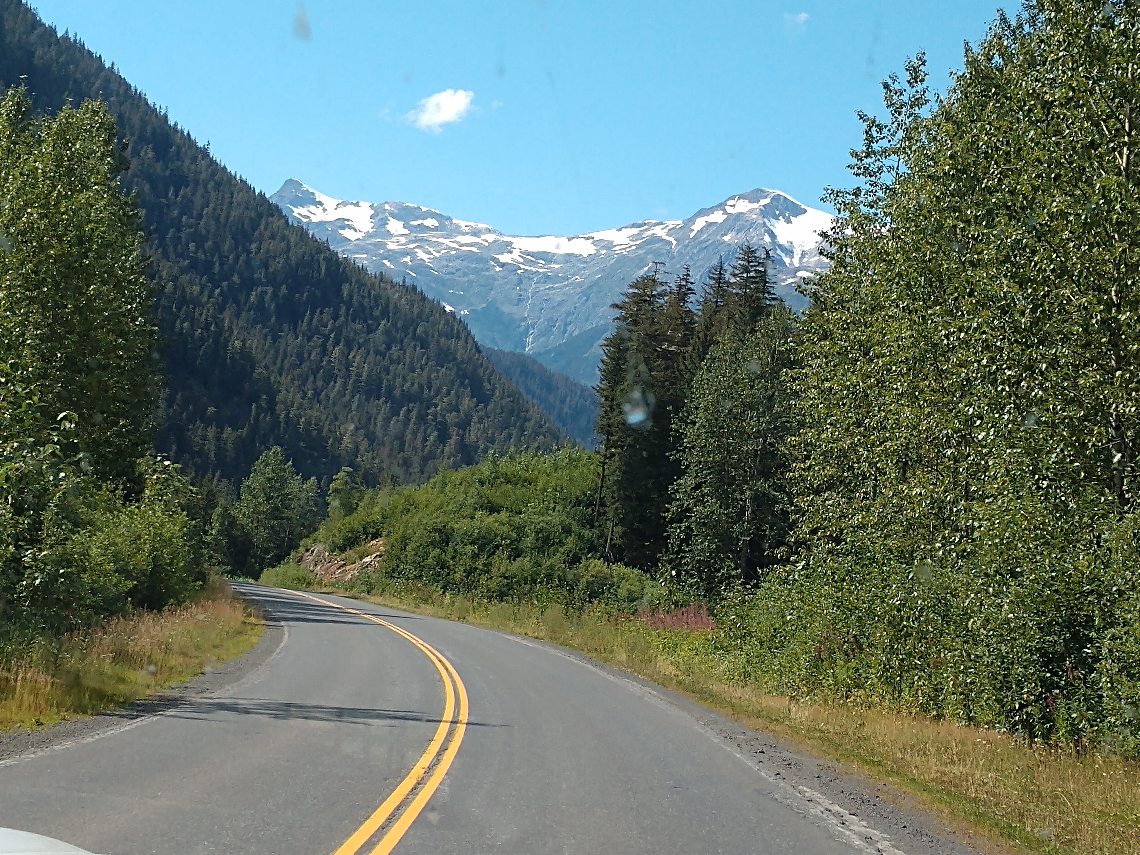
The incredible scenery starts almost immediately as we see lots of snow ahead on the mountains.


Above is the Department of Highways yard with two large shelters for storing equipment and sand/gravel for sanding the highway in the winter.


We are now crossing Surprise Creek Bridge. See Surprise Creek in the picture below.


What beautiful scenery we continue to see along the way to Stewart.


We now cross over Entrance Bridge. The drive cutting through the Coastal Range and over the Bear Pass from Meziadin Lake to Stewart and Hyder is truly one of them most scenic in British Columbia. The road took us past many hanging glaciers, all visible from the highway.


We now crossed over Cornice Bridge.


And then we crossed Strohn Creek Bridge.


The highlight of the drive along Highway 37A (Glacier Highway) was our first glimpse of the Bear Glacier (see below), ending in Strohn Lake, a slate green lake right on the edge of the road.

Bear Glacier (see above and below) used to fill the whole valley, but in the 1940s it began to retreat rapidly. Strohn Lake formed in the basin left behind, dammed by the remaining ice. The lake would ocassionally break through the glacial dam, causing catastrophic flooding downstream. This is known as a jökulhlaup, the Icelandic term for the event - between 1958 and 1962, there were five jökulhlaups here, and the damage can still be seen right to Stewart. By 1967, the glacier had retreated far enough that Strohn Lake was no longer dammed.


Next we crossed the Cullen Creek Bridge.

Then we passed the Rufus Creek Culvert.


And then we crossed the Bear River Bridge.


We caught glimpses of waterfalls along the mountainsides.


As we madee our way to Stewart and Hyder, we drove through Bear River Canyon, Bear Creek Canyon, and the Coast Range Mountains. These mountains are snow-capped for much of the summer and we saw waterfalls trickling down.

It is now less than one mile to Stewart.


As we once again crossed the Bear River Bridge, we saw the sign for our campground -- Rainey Creek Municipal Campground.


A wooden carved bear with a fish in its mouth welcomes us to Stewart, B.C.

We are finally at Stewart, British Columbia. After miles and miles of driving without many towns in sight, Stewart is a great little surprise! Although a very small town, it is very charming. It has a bunch of historic buildings that make up the downtown area, all with an epic mountain and water backdrop.

Stewart is a very small town sitting at the head of the Portland Canal, a steep, narrow ocean fjord that forms a natural boundary between British Columbia and Alaska. It is surrounded by some of the most spectacular scenery anywhere. Before the stock market crash of 1929, Stewart was a boomtown and its pre-World War I population was over 10,000. It was the base for those working in the enormous and fabulously rich Premier gold and silver mine, the Big Missouri Mine and the Riverside Mine. Now Stewart has a population of approximately 500 and is located at sea level. Stewart has a deep harbor and boasts of being Canada’s most northerly ice-free port.
The town sprang into being in 1898 when 68 eager prospectors came to the area at the head of the Portland Canal in a quest for placer gold. The rumor was, the deposits were comparable to those in the Klondike. The pannable gold never materialized, but the attention increased mining exploration in the area.
The settlement was later named Stewart for American mining bothers who prospected here at the turn of the century. The Stewart brothers arrived in 1902, and in 1905 Robert M. Stewart, the first postmaster, named the town Stewart. Stewart has a fair share of historic buildings and homes, which make it interesting and quaint and there is a long boardwalk walkway crossing the tidal flats.

Above is a street in Stewart. We drove to the Rainey Creek Campground located on 8th Avenue.


The Rainey Creek Campground was conveniently located just a couple of blocks from downtown Stewart. It had beautiful and whimsical campsites for RVs and tents huddled in the big trees of Stewart, BC!

We got set up on site# 58 for two nights for a total of $71 CA (or $51.40 US, which come to $25.70/night). Not too bad!


This afternoon, we decided to ride our bikes into the Stewart townsite to the grocery store and the visitor center.

The above storyboard at the Stewart Visitor Center told us about "Stewart/Hyder: 100 Years of History;" while the storyboard below told us about "Highway 37: For the Adventurers."

The storyboard below told us about the "History of the Highway."


Above is the Stewart Visitor Center building.

Above is a memorial dedicated to the men from the Portland Canal District who died in World Wars I and II. It is located in a small park just across from the visitor center.

Above is a storyboard that told us about "Stewart's Main street from 1910 to the 1930s."

Above is the Garmin map of where we rode on our bikes around Stewart.

After our bike ride, we went back to the campground. Below is the wooden bridge that crosses Rainey Creek in the campground.


The Rainey Creek Campground map is shown below.

Monday, August 7, 2023
Today started out cloudy and rainy at 61 degrees.


Shown above is St. Marks Community Church built in 1979.

Above is the the old fire hall. Built in 1910 as the fire hall and government office, this building and its grounds became the museum in 1976. Below is an old vintage firetruck (Ford 1938).


Above is a plaque commemorating the Anglo-Russian Treaty of 1825. The Treaty of Saint Petersburg of 1825, officially the Convention Concerning the Limits of Their Respective Possessions on the Northwest Coast of America and the Navigation of the Pacific Ocean, defined the boundaries between Russian America and British claims and possessions of the Pacific Coast, and the later Yukon and Arctic regions of North America. It was agreed that along the coast at the southern tip of Prince of Wales island northward to the 56 parallel, with the island wholly belonging to Russia, then to 10 marine leagues inland going north and west to the 141st meridian west and then north to the "Frozen Ocean", the current Alaska/Canadian Yukon boundary, would be the boundary. The coastal limit had, the year before, been established as the limit of overlapping American claims in the parallel Russo-American Treaty of 1824. The Russian sphere in the region was later sold to the United States, eventually becoming the State of Alaska, while the British claim, along the coast to the south of parallel 54°40′ is now the coast of the Canadian province of British Columbia, and for inland regions it defined the western limit of what became the modern day Canadian territory of Yukon.

Above is D. J. Raney's cabin, first house in Stewart that is located at what is now Rainey Creek Park. The commencement of the line at the head of the Canal was the course taken by Columbia Street, and D. J. Rainey applied for a pre-emption of the land west of this under Alaska regulations. J. W. Stewart applied for the land to the east in 1902. Later when the boundary was established, Rainey purchased his land from the Provincial Government. Rainey was one of a party of 65 men who landed at the head of the Canal in May, 1898, to re-discover placer diggings somewhere in the interior. The party was headed by a man of the name of Burgess, who had in some way obtained a map showing where the ground lay, and organized the party in Seattle, each member contributing $25 towards expenses.
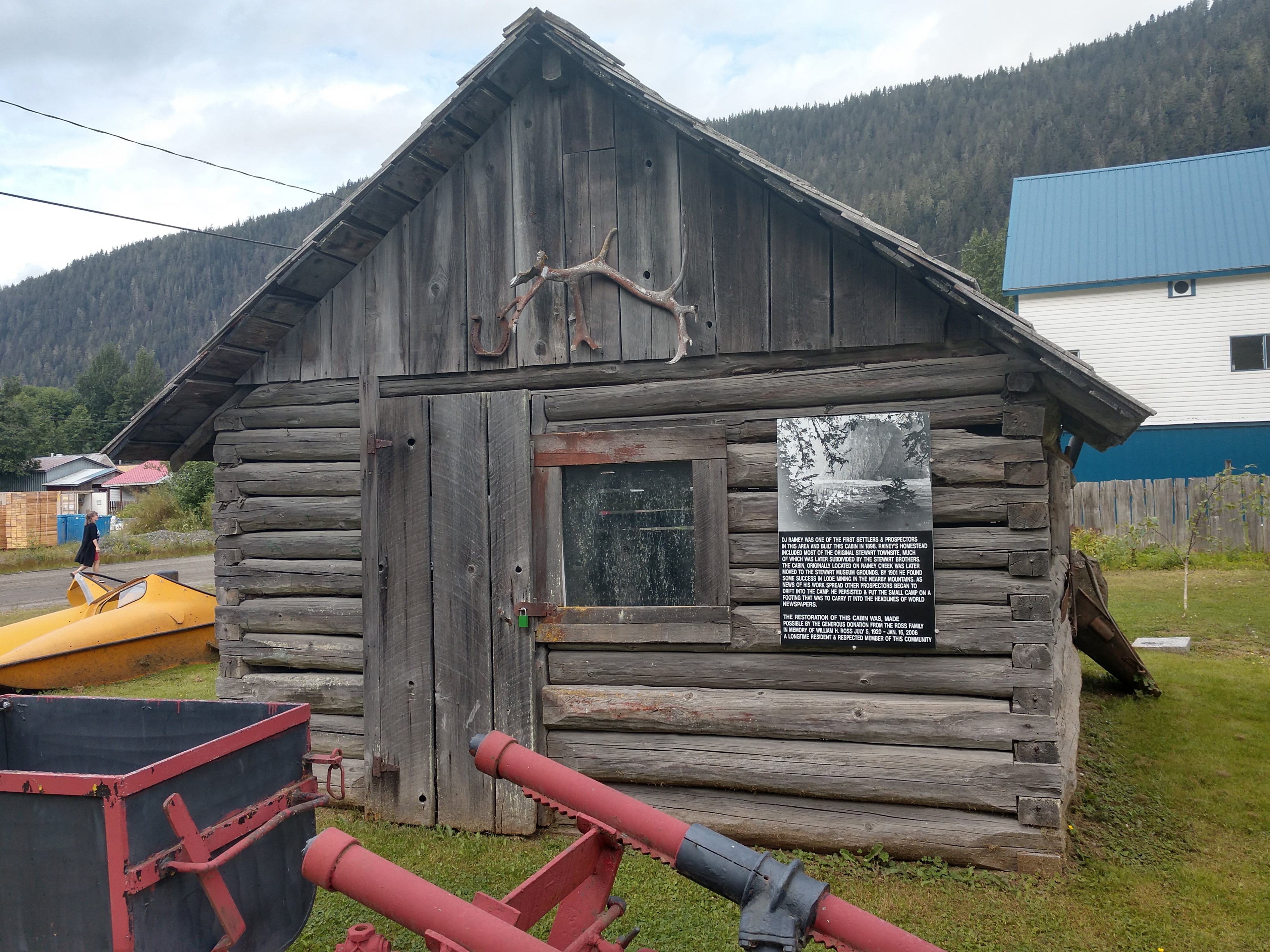
But no diggings were found and hostility was manifested against Burgess, who, fearing for his life took the opportunity to escape in a boat with Harvey Snow, a prospector form the Nass, who had arrived following information given him by Indians that a large party of white men were at the head of the Canal prospecting for gold. Snow figured to be in on the strike, but when he found how matters stood he closed a deal with Burgess to take him away in his boat for $50; and in the night they left arriving two days later at Nass Harbor, where Burgess caught a steamer for the south and was not heard from again.

We walked arond looking at what equipment was on the land at D. J. Raney's cabin.


Above and below are a couple of murals in Stewart.


Above and below is the historical Empress Hotel. The former Empress Hotel was built in 1908 by Alvo Von Alvensleben, then opened to the public in 1910 and was the most upscale hotel in the North -- rivaling that of the Empress Hotel in Victoria. The hotle stopped rumming during World War I and in 1919 became the North star Theatre. Still standing today, it remains the largest building in Stewart.


Shown above and below, this Masonic hall dates from 1937 (built by Duncan MacLean) and was renovated in 1995 but sadly looks a little past its best now.


Above shows the cottony seeds of the fireweed. The seeds have a tuft of silky hairs at the end. A single fireweed plant can produce 80,000 seeds! The delicate fluffy parachutes can transport seeds far from the parent plant.

Above is the Stewart Museum, that is run by the Stewart Historical Society. The Museum has been a vibrant part of the community since it opened in 1976. With a rich mining culture, the museum prides itself in the preservation of the history and memories of the community.

The Stewart Museum director invited us in for a tour of the facilities. We spent over two hours looking at the exhibits and watching the featured docomentary film, "Mountains of Gold."


First discovered in 1931, a large avalanche killed 28 men on February 18, 1965 when a snow slide hit the mine camp. The property saw limited exploration in 1991 and again in 1993 after its dormancy until 2005, when new exploration reopened interest in the property. Site construction and ground rehabilitation, began in 2014 with active production expected for 2016.


Museum Director, Shirley Rosichuk (shown above) is passionate about presenting the past, present and future visions of her community to visitors and locals alike! When she's not busy working in the collections, Shirley loves to enjoy the breathtaking views that Stewart provides, through hiking and fishing.

Below is the Premier Gold Mining Company Payroll ledger from 1919.


Above and below is a portion of the story of those buried alive in the avalanche in Stewart, BC on February 18, 1965.


Above is a photograph of the Stewart brothers (George, Robert, John, Andrew, and James).


The information above told us about Hyder in the early 1900s.


The information above told us that Stewart was one of the busiest ports in the Northwest in the 1920s.
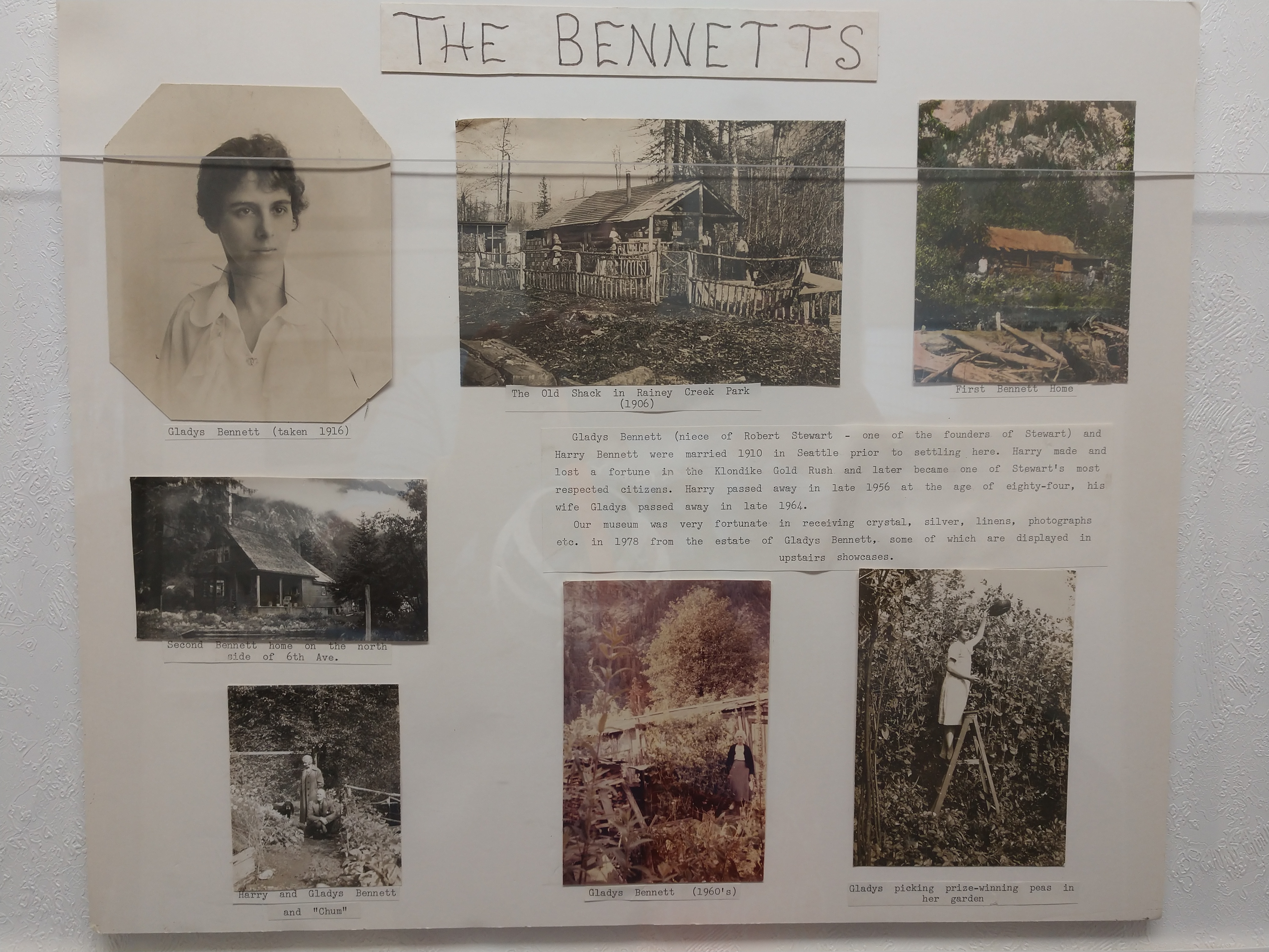
The information above tells about the Bennetts who lived in Stewart in the early 1900s.

Below is a photograph of a group of woman at a picnic at Bear Lake.


Above is a cherry wood tray hand-embroidered by Mrs. Gagin.

The next dozen or so pictures are antiques in the numerous rooms of the museum.


Walking down the hallway toward the movie room, we saw an elaborate collection of stuffed wild animals (see below).


The above sign told us how to tell the difference between the grizzly bear and the black bear. We went in the movie room and watched the "Mountain of the Gold" documentary film. It was really good.

In the movie room, on the four walls were posters of the movies that were filmed in Stewart, British Columbia. (See the list below.) I'm going to try to see some of these movies when we get back.

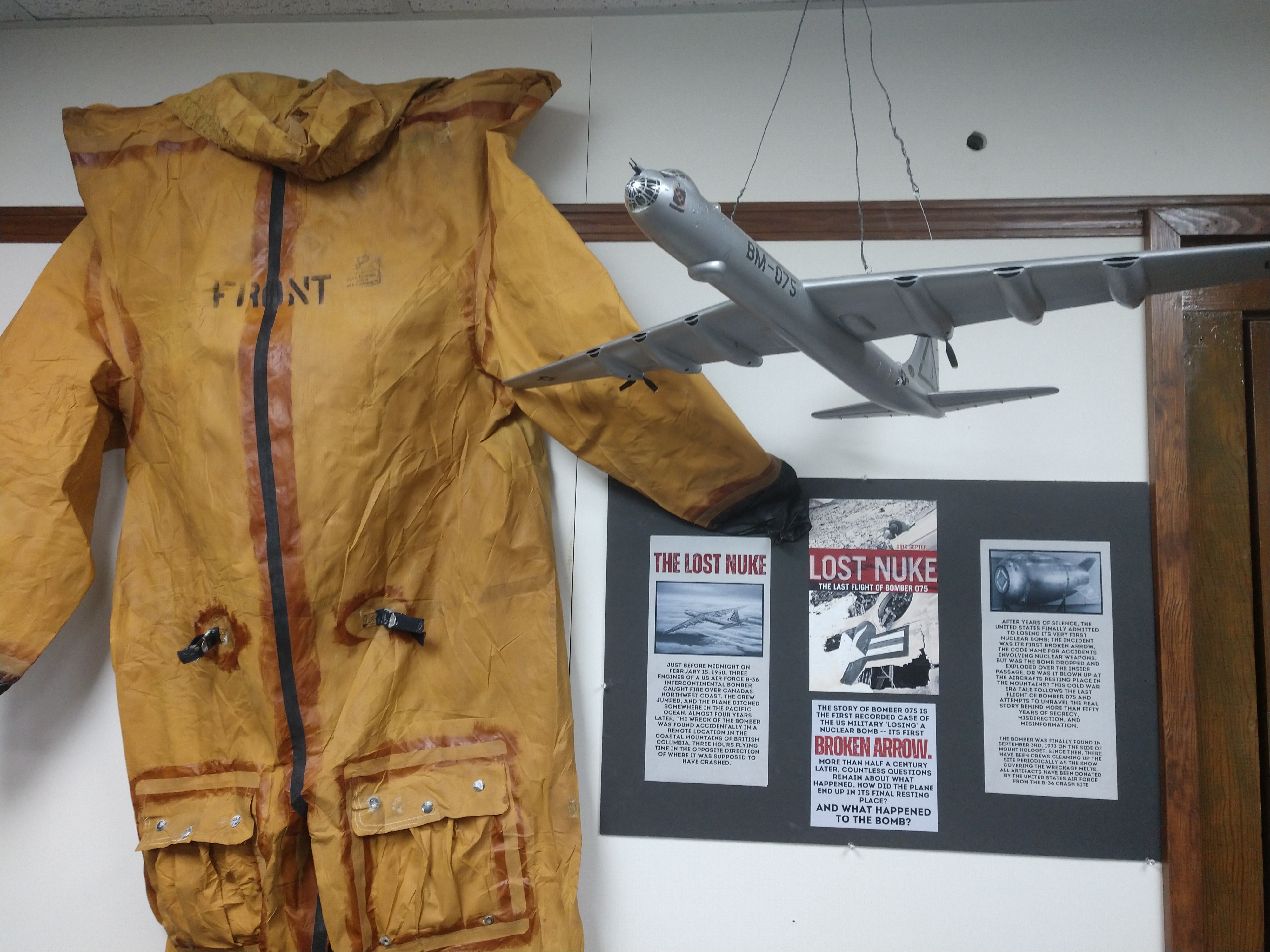
The was also a display about the documentary on LOST NUKE (shown below) -- In February 1950, the world’s largest bomber disappeared with its MK IV nuclear bomb on a secret Cold War mission. In this incident in which an engine fire forced the 17-person crew of an Air Force B-36 bomber equipped with a nuclear weapon to abandon the plane over the British Columbia coast. A massive search-and-rescue operation followed, but the plane and five missing crew members and their nuclear weapon were presumed lost in the depths of the Pacific Ocean. Five decades later, an expedition team travels to the mountains of northern Canada to investigate the crash site and uncover the truth of what happened during America’s first “Broken Arrow” incident. Three years later, however, the plane was found on Mount Kologet, nearly 200 miles north of its last known location.
The information shown below told us about the "Show Night at Premier Drawing Crowds to the Mine" from the June 14, 1934 Northern Argonaut.

"Highly enjoyable is the drive through rugged country to Premier Mine. Saturday nights, several stage loads of Stewartites together with numbers of owners of private cars drive up to Premier and have the pleasure of seeing an exceptionally good show. Not only is the theatre attraction out of the ordinary but it is the privilege for anyone to have the opportunity of an evening motor outing such as is afforded when going through the lower tip of Alaska from Stewart to Premier. In a way, it is a unique experience to be able to leave your home after dinner, pass in and out of a foreign country, see a new picture at every turn of the highway and arrive in time for the evening's performance. We know that many thousands of people in the larger centers of population would give a hundred dollar bill to travel through fifteen miles of scenery better than anywhere in the world. The management of the Premier Mining Company is to be commended for providing such high grade amusement for their employees and all others of the district."
Some of the movies screened at the Premier included: "Half Marriage" - October 24, 1930; "Broadway to Hollywood" - July 3, 1934; "Lawyer Man" - July 6, 1934; "Tugboat Annie" - July 13, 1934; "Havana Widows" - August 21, 1934 and many more.
* * * * *
The next few pictures are historical photographs of buildings in Stewart, British Columbia.

Shown above is the Bayview Hotel, that was built in 1925 and restored in 1994 and 2018. This is one of the few original buildings remaining after the fires that destroyed the 5th Avenue Main street. Shown below is what the Bayview Hotel looks like today (see the green building).


Shown above is historical information about the King Edward Hotel, while below is what the King Edward Hotel looks like today.


Above is information on the historic Newell Rooms in Stewart.

Above is information on St. Mark's Church in Stewart, while below is a current picture of the church.


Shown above is Stewart's first school from 1911.

Shown above is the busy corner in Stewart in May 1910.
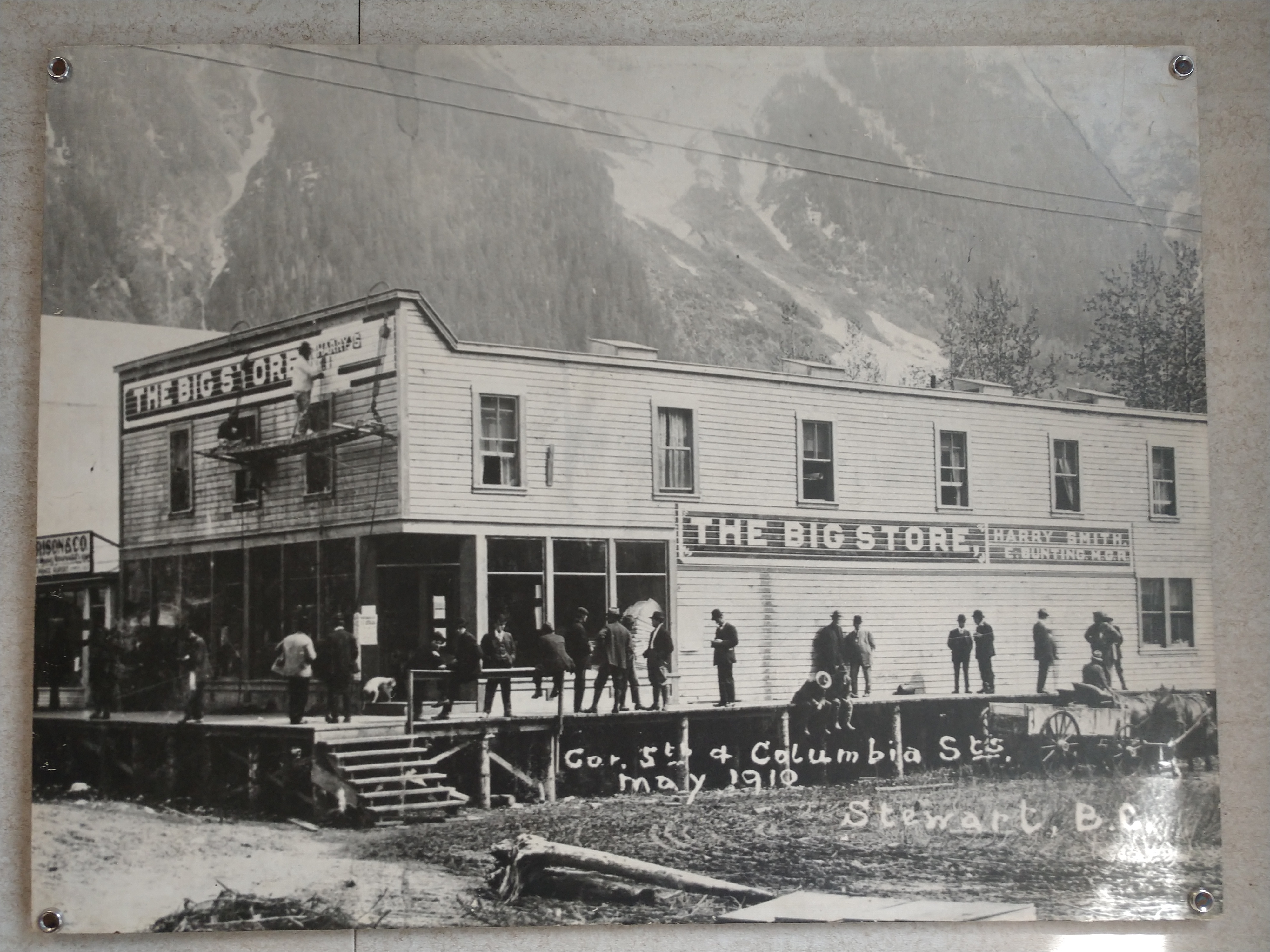
Above is "The Big Store" on the corner of 5th & Columbia Streets in Stewart in May 1910.

Above shows the corner of 6th & Columbia Streets in Stewart.

Shown above are some of Stewart's public institutions.

At the Stewart Museum, I saw this wood carved bark face by Rick (see above) and wanted to learn more.


Above is Rick Jensen carving a face in cottonwood bark. He has taught America how to carve faces and cottages from cottonwood bark. In midevil times, peasants believed that spirits dwelled deep in the trees, and if they carved a face into the wood, the spirit would be released and good luck would come upon the carver.

Rick Jensen has been carving cottonwood bark—literally, the thick bark of dead eastern cottonwood trees —for 30 years. The Minnesota native has been teaching his techniques in classes, at shows, and in print for nearly as long; and thanks to him, whimsical bark houses regularly appear at carving shows and competitions around the country.

When carving faces, he prefers a piece of bark that is at least 3 inches thick and a minimum of 3 inches wide. Of the barks that he has carved, his favorites are Plains cottonwood and Black cottonwood. Plains cottonwood grows in southern Alberta, central Saskatchewan, and southwest Manitoba, Canada, and south throughout the Great Plains into North Dakota, South Dakota, Nebraska, Wyoming, Colorado, Montana, Kansas, and eastern Oklahoma. Black cottonwood grows from western Wyoming to Montana, Idaho, northern Utah, Nevada, northern California, Oregon, Washington, British Columbia, the Yukon, and the coast of Alaska. Black cottonwood grows in excess of 6 inches thick and Rick feel that it is the very best for carving. Remember that the bark used for carvings needs to come from dead trees (as it takes bark from two to three years to loosen on a dead tree).


Rick adds some color to his Santa face wood carvings (see above). The finished one is shown below.

Thanks to Rick — we are seeing bark houses, castles, lighthouses and whimsical treehouses — pieces with incredible detail, but also a sense of humor. Rick started carving at age 7, when his father gave his first pocketknife to him. He whittled sticks for years, gradually learning to control the cuts. He carved his first decorative piece, a redwood ram, while in high school. Rick's bark carvings are mind-blowing! Rick adds a new twist every year, and they are simply amazing!
* * * * *

Probably one of the most photographed buildings in Stewart, the Kate Ryan building (shown above) built in 1920, stands as a bright reminder of Stewart's gold rush history. Kate Ryan (Klondike Kate) accomplished many things in her lifetime (1869-1932). She was the first female member of the North West Mounted Police (appointed as a special constable in 1900) and helped establish order among those involved in the Gold Rush. An adventurer, a traveler, an educator, a nurse, a prospector, a restaurateur, and a mother-figure to most who knew her, Klondike Kate carved out for herself a legacy, and became a legend at the same time.

Klondike Kate was born Katherine Ryan in 1867. She grew up in a large Irish family in Johnville, New Brunswick.

(Shown above is a young Kate Ryan.)
In her twenties, she fell in love with a boy from a wealthy family and it seemed like they might get married, but his mother refused to allow it because she was poor. Heartbroken and ashamed, Kate decided to make the first of many very bold moves for a woman of her time. She moved, all alone, across the continent to Seattle to train as a nurse and built a whole new life for herself. Perhaps emboldened by her success the first time, Kate soon prepared to set out on a new adventure. In 1898, she joined the Klondike Gold Rush.

(Shown above is Kate Ryan and her nephews.)
Joining the Klondike Gold Rush was no whim for Kate. She was going to be prepared, not only because of the regulations that required it, but because she wasn’t going to give the inspectors any excuse to deny a single woman entry. She shopped for all of her supplies at the Hudson Bay Company in Vancouver, which at the time was like a department store, hardware store, feed store, and grocery store combined. Her thorough preparations so impressed the store manager that he gifted her an expensive leather satchel and said, “Any lady with the courage to head out to the Yukon on her own deserves the support of the Hudson Bay Company."
They even made a movie about Klondike Kate (see below).

Below is information on the historic Marmot Hotel in Stewart.


Shown above and below is the Marmot Bay Trading Company in Stewart, built in 1928 by Crawford & Transfer. It was used as a freight office for hay, coal and mining supplies. It is now a gift shop.


The Harbour Lights Grocery store is a colorful little business with old grocery carts mounted along the roofline. This building was originally built in 1936 by W.R. Tooth and was the Bank of Montreal for 39 years.


Next we decided to walk the estuary boardwalk (see above and below) in downtown Stewart. Starting at 5th Avenue and stretching 278 feet on a raised boardwalk across the tide flats to Highway 37A, this precious estuary ecosystem at the head of the canal was easily explored.

Mel began walking the boardwalk.


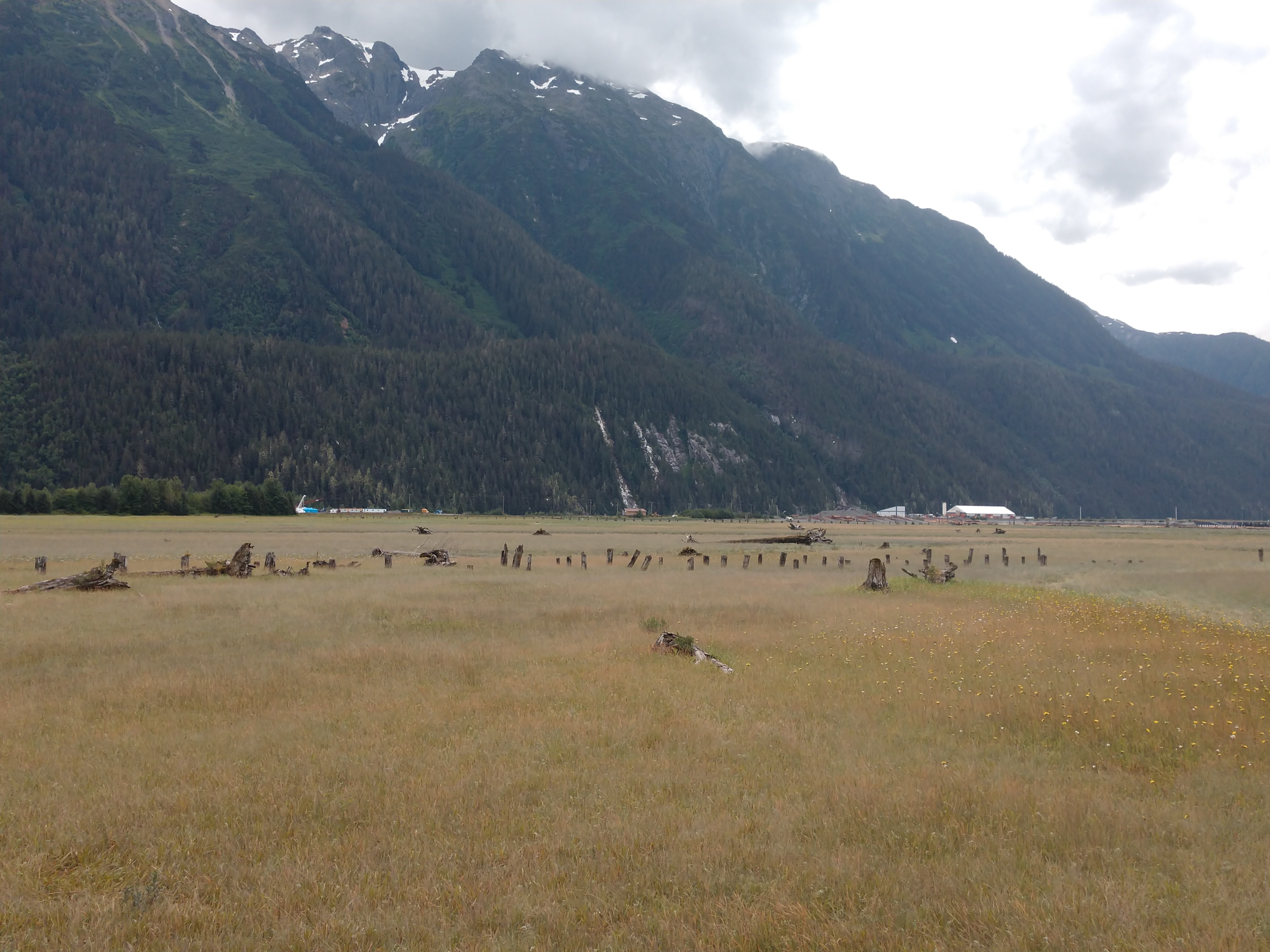
The scenery was beautiful and we could even see some of the old rotted piers or posts from an old wharf. This was a delightful walk over the estuary with interpretive signs identifying the flora and fauna of the area along the way. It was about a 15 minute walk out over the marsh and then back.


From the estuary boardwalk, we were able to see all the way out to the Portland Canal. Stewart is at the tip of the Portland Canal -- a passage that stretches 71 miles to the Pacific Ocean. The American Misty Fjords National Park mountains can also be seen just across the canal.

.png)
Shown above is my Garmin map screenshot of where we walked this morning in Stewart (about 3 miles), while below below is my Garmin map screenshot of where we walked this afternoon in Stewart (a little over one mile).
.png)
For dinner tonight, we had spaghetti and then relaxed for rest of the evening. Our journey today was very inspirational with lots of history and beautiful sights!
Shirley & Mel


No comments:
Post a Comment