Today we traveled a little over three miles from Stewart, British Columbia to Hyder, Alaska. The day started out at a temperature of 57 degrees with cloudy skies and rain off and on.

As we left Stewart, it was somewhat gloomy out, with the clouds hanging very low and lots of raindrops falling on the truck's windshield.


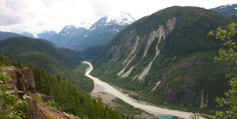
As we drove along Highway 37A (also known as the Glacier Highway) toward Hyder, the clouds became increasingly heavier.


We're now nearing the Hyder Bridge. The road for a couple of hundred feet at that point is called the Hyder Bridge because it’s completely built on pilings.


As we are entering Hyder, there is no U.S. Border Customs area for the entry into Hyder, Alaska, however as you can see from the picture below, Canada has a Border Customs area that we will have to go through on our return back to Canada.


Besides Hyder, Alaska there was a Hyder, British Columbia (see historical photo above). Hyder, British Columbia came into being partly due to Premier Mine’s activities and to the influx of Hyder, Alaska residents during prohibition. History has it that there was a well worn trail over the mountain from the Alaska side known as “Smugglers Trail”. Many Alaskans would just walk over to Hyder, B.C., drink their fill and return home.


Welcome to Hyder, Alaska -- as we were just inside the border, we noticed a small stone structure (see above) and stopped to investigate. It turned out to be a “storehouse” built in 1896 by Captain Gaillard of the U.S. Army Corps of Engineers. He was ordered to investigate Portland Canal and build four storehouses along the west bank – Storehouse no. 1 and 2 on Pearse Island; Storehouse no. 3 in Halibut Bay (ruins remain); and Storehouse no. 4 at Hyder, still seen today. Storehouses 1 and 2 are now on Canadian soil as a result of the 1903 Boundary Tribunal decision when the Alaska-Canada border was re-established north of Pearce and Wales Islands. The storehouse in Hyder is listed on the National Register of Historic Places and is maintained by the Bureau of Land Management.

.jpg)
As we drove into Hyder, Alaska, it truly looked like a ghost town compared to Stewart, British Columbia. Looking back after we entered Hyder, I noticed that the exit banner read, "Leaving Hyder. The Friendliest Ghost Town in Alaska!" (See below.) For the most part, Hyder was pretty run down and many of the buildings boarded up, collapsing, closed and/or for sale.
.jpg)
Hyder was settled by many of the same miners and prospectors who came through the Stewart area. The town was originally known as Portland City, but the U.S. Post Office rejected the name of Portland, feeling there were already too many in the United States. The name was then changed to Hyder, Alaska in 1915, after Frederick B Hyder, a Canadian engineer working for the Juneau Gastineau Mining Company. As with Hyder, British Columbia, all that remains of much of the old town are pilings located on the tidal flats.
Hyder, Alaska may be one of the few places where nature still rules. It is a place to wake in the morning and breathe pristine pine mountain air and at the same time see bald eagles soar through a misty sky. It is where one of the world's largest glaciers seeps ever so slowly down a meandering valley, and grizzly bears fish in a shallow creek to catch the world's largest chum salmon. And it is a place that seems to exemplify Alaska's nickname, "The Last Frontier."
.jpg)
Although the two towns, Hyder and Stewart are in different countries, they do share the same telephone area code and most clocks in Hyder are set to Pacific Time (as is British Columbia), not Alaska time.
The Hyder area was first explored by Nass River Indians, who picked berries and hunted birds there. In 1896, a United States Army Corps of Engineers captain named D. D. Gaillard explored the Portland Canal in search of gold. He constructed the first building in town, but found very little gold in the Bear or Salmon rivers. Ten years later, small gold and silver lodes were found, but there were not as full as regions like the Klondike.
.jpg)
Hyder was established in 1907 as "Portland City," named after the canal (see storyboard above). In 1914, when the U.S. Post Office Department told residents that there were many U.S. communities named Portland, it was renamed Hyder, after Frederick Hyder, a Canadian mining engineer who envisioned a bright future for the area. By 1917, it was the main ocean port and supply point after the surrounding Canadian regions were found to be rich with silver. Hyder was the only practical point of access to the silver mines in Canada; the community became the port, supply point, and post office for miners by 1917. Hyder's boom years were the 1920s, when the Riverside Mine on the U.S. side extracted gold, silver, copper, lead, zinc, and tungsten. The mine operated from 1924 to 1950.
A post office was built which also assisted with prospector's needs and valuable commerce. A historical museum in Stewart contains in-depth prospector tales and numerous artifacts. Hyder reached the climax of its boom years in 1929 when its population reached 250, and the Riverside Mine produced zinc, silver, gold, copper and tungsten, which became especially valuable during World War II. But by 1945, only 17 people lived in Hyder, and it was considered one of North America's ghost towns. But somehow, Hyder survived.
The regal bald eagles fly above the town, perch in Sitka spruce trees, or wait on the banks of the Portland Canal for fish. Beside that, visitors like to explore Salmon Glacier Road and get back to nature. The Salmon Glacier, the fifth largest in Canada, is a remnant of that last great age of glaciers.

Above and below is the Hyder Post Office.
.jpg)
Mel was walking around Hyder and found this old bus (see below) -- and guess what it had the same number "42" as the bus he used to drive in Willis, Texas!
.jpg)

We drove by the Glacier Inn on our way toward the campground.

.jpg)
Then we drove by the old Hyder General Store.


Then we drove by the General Store that looks like it is being used as a bed & breakfast.


Soon we were at Camp Run-A-Muck, where we stayed on the edge of Hyder. Some of the sites in this campground were deep in the woods, but our site was a full hookup site. The entire campground was cradled by the Titanic mountain ranges displaying glacier-capped peaks.


After we got all set up in the campground, we started out on the Granduc Road toward the Fish Creek Observation Site and Salmon Glacier. We followed the Salmon Glacier and Highway 37A Glacier Highway Self Guided Auto Tour (shown below) that we had picked up at the Stewart, B.C. Visitor Center.

The map shown below helped us identify the specific sites along the Granduc and Salmon Glacier Road.


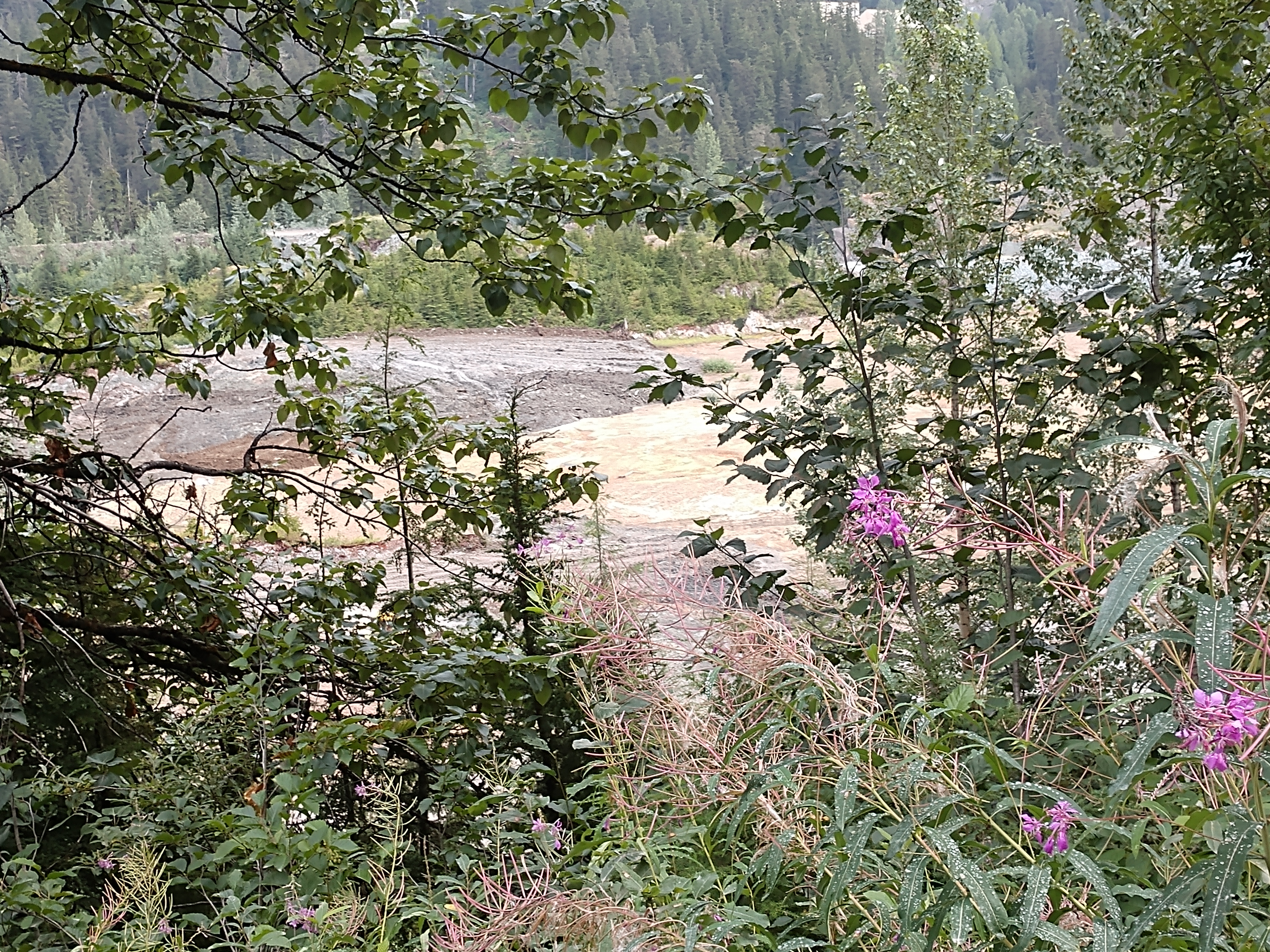
We drove along the Salmon River.


The dirt road then passed Moose Pond that was named for the Loyal Order of Moose, a fraternal organization -- but there aren’t any moose there. This very scenic beaver-heightened marsh (see pictures above and below) is located just outside of Hyder along Granduc Road (STOP #5 on the Auto Tour Map). The pond is home to ducks, Canada geese, beavers, red squirrels and spotted frogs. Bald eagles, seagulls and bears can be also seen here.

The Granduc (Salmon Glacier) Road was completed in 1965, from the Premier area, to the Granduc Mine site located 25 miles north-northwest of Stewart. The road winds its way through some of the most spectacular and rugged scenery in the world as it passes along the eastern edge of the Salmon Glacier and Summit Lake to the site of the Granduc camp.
It was 1931 when the first noted copper showing was discovered. No real interest in the area was shown until 1948, when Einar Kuala staked claims in the Leduc Area. In 1953, Granby Mines took an option on the property and flew in drills and equipment. In 1954, Newmont Mining Company, negotiated for half interest of Granduc Mines.
In 1964, Newmont began it’s development and it was decided a 11 mile tunnel had to be driven under the mountain ridges and glaciers to get the ore from the Leduc camp to the concentrator site at Granduc camp. The tunnel was completed in 1968. Granduc operated until 1978, when production costs and copper prices saw the closure of the mine. In 1979, Canada Wide Mines Ltd, began rehabilitation of the property and operated it until 1983. Work stopped and a total shutdown of the property occurred. In 2010 Castle Resources Inc. acquired a 100% interest in the Granduc property. In 2012 and 2013 there was some mining and tunnel rehabilitation on site.
Granduc Road leads to the Fish Creek Wildlife Observation Site that is just a few miles past the town of Hyder, and then it goes on for several miles to Salmon Glacier.

We are now driving along the most popular spot to watch bears -- the Fish Creek Wildlife Viewing Area (STOP #6 on the Auto Tour Map). Hyder is a world-class destination for Grizzly and Black Bear viewing during the salmon spawning at the Fish Creek Wildlife Observation Site. The bears come here to feed on the coho, chum and pink salmon which spawn in the creek. From July to September, the salmon run provides an extensive food supply for bears, sea gulls, bald eagles, and wolves. The wooden observation deck allows curious humans the opportunity to see black bears and grizzly bears. We bought 3-day passes to watch for bears at $10 each.


-L.jpg)


Above is the turnoff for Titan Trail (STOP #7 on the Auto Tour Map). Titan Trail was constructed in 1922 by workers from the Titan Mine. The original trail was approximately 5 miles long and provided access for horse and mule trains to carry supplies to the mine site and other claims in the area. The trail is now maintained by the U.S. Forest Service to the old mine site.

The almost three miles further down the road (STOP #8 on the Auto Tour Map), we passed an abandoned mine site (shown above) with it's equipment left to rust. I believe it may be part of the Riverside Mine.

Riverside Mine (see the historical photo above)was discovered by the Lindsborg Brothers in 1915 and claims were sold. Development began in 1922 and some 4,000 feet of tunnel was constructed over the next two years. In 1925, construction of a 60 ton mill began. The mine changed hands several times and was operated intermittently until 1961.
In some years, the Riverside Mine was the most productive property in Alaska for silver and copper. At one time, facilities at the mine included the mine head mill, quarters for 60 workers, a cook shack and dining hall. By 1987 most of the original structures had burned down and river floods had washed out the original road. The present road now covers part of the original mine area. Today, only the remains of the burned structures identify the most important mining property in the Hyder area.
From here, Salmon Glacier Road continued on to Nine Mile climbing more abruptly to almost 4,400 feet and then becoming a fairly rough gravel road.
At Nine Mile (STOP #9 on the Auto Tour Map), Texas Creek joins the Salmon River as it widens out across the valley, flowing south to the Portland Canal. Here the remains of the Nine Mile Bridge can be seen along the river bed. The bridge gave access to mineral properties in the Texas Creek drainage until 1967 when a dumping event from Summit Lake washed out the structure.

Shown above is a historical photograph of the Texas Creek Bridge that was located 3 miles up the Texas Creek drainage. It was at one time Alaska’s only covered bridge. It provided access to a number of mineral claims in the upper Texas Creek area from the time it was built in 1932 until 1965 when it was damaged under a heavy snow load. In 1978 the structure finally collapsed.

In the picture above, Texas Creek (in the background) joins the Salmon River. In the foreground, the wreckage of a bridge that provided access to mineral properties in the Texas Creek drainage until 1976 can be seen.
Summit Lake is a self dumping lake, located above the Salmon Glacier, and normally drains northward into upper Bowser River. The first recorded flood (an event known as a Jokulhlaups, pronounced Yuck-a-lups) occurred in December 1961. The lake drained under the glacier, raising the level of the river and filling it with ice bergs. This resulted in catastrophic flooding along the Salmon River valley. The lake then began a cycle of filling and draining, flooding the Salmon River, causing damage to the road and bridges along the river. The event now occurs almost every year, raising the water to flood level and depositing ice chunks along the river, but without much damage to the road.


The gravel road was pretty muddy and rough in spots. We encountered a lot of mining trucks.


About three miles past Nine Mile, the road reaches the Premier Border Crossing (Silver Heights - STOP #10 on the Auto Tour Map). This is the international border between Alaska and British Columbia, but there is no customs check-in spot.
The international boundary between Alaska and B.C. was officially designated in 1903 by a commission established to resolve the Alaska – Canada boundary dispute. The Commission was made up of members from Canada, the United States and Great Britain. The boundary area just below Premier, B.C., was referred to as Silver Heights. From the 1920s to the early 1950s miners going to work and residents of Premier Mine Camp had to stop here at a Canadian Customs building. Every ten years the entire length of the boundary from Hyder north is cleared (see picture below showing the border cut line).

Miners working in this area from the 1920s to the early 1950s has to stop at this point at a Canadian Customs building. The boundary line is on the east side of the road was marked by a small cairn. Premier Mines, one of British Columbia's richest mines, was once located in this region and in 1921 alone yielded $1.5 million in gold.

After the simple boarder crossing, we are now back in British Columbia.


We followed the sign and turned left to continue on our way to Salmon Glacier.

The road was dusty as there was lots of mining traffic.


We continue on and at mile 15 we had reached the Premier Mines Viewpoint.

(STOP # 12 on the Auto Tour Map) is the Premier Mines Viewpoint. Located on the eastern slope of the Salmon River Valley, Premier Mine was started in 1910. By 1918, Premier had developed into one of the richest mineral deposits in B.C. An 11 mile aerial tramline was constructed to carry ore from Premier to tidewater and was one of the longest on the continent at that time. In 1921, the property shipped 6,000 tons of ore with the gold valued at $1,500,000 at that time. A large fire devastated the camp in 1928, resulting in the destruction of most of the buildings. Through heroic efforts, the mill machine shop, compressor plant and tramheads were saved. These were vital to the operation of the mine as loss of them could have resulted in the closure of the property.
The camp was rebuilt and Premier Mine Camp once again became a thriving community. Many years of success and continuous operation were experienced until low base metal prices forced closure in 1953. Development resumed in 1955 and continued sporadically until 1967. The property sat idle from 1967-1988, other than some exploration in the early 80s. In 1988, Westmin Mines began construction on the property and undertook open pit mining from 1989-1992. In 1993, Westmin began underground operations continuing until 1996.

Above is a closeup of some of the mining activity.


Near the first summit, we got a view of one of the bigger mines in the area (see above). The active area is visible on the far canyon wall.

As we continued on, we saw a few small waterfalls in amongst the rocks.
From close to the mine site, we got a nice view of the river heading toward Hyder and the Portland Canal beyond (see above).


As we continued on, we were reminded about the avalanche terrain that we were heading into.

There is a pretty heavy cloud cover now, but we are hoping we will still be able to see Salmon Glacier.


Finally, the first signs of the toe of Salmon Glacier come into view (STOP # 13 on the Auto Tour Map - see above) at mile 17 down the road. Looking down from the highway to the toe of Salmon Glacier and along the valley below, we could see how the glacier is continually transforming the landscape and itself.
At the toe of the glacier, there are a series of small ridgelike accumulations. These ridges are made up of till that have been deposited across the valley, and are known as Terminal or End Moraines. These Terminal Moraines mark standstill positions of a present or past glacier front. Notice the small ponds located below the toe. These depressions, known as Kettles, are formed by the melting of buried ice blocks, which are stranded on the outwash plain after the glacier recedes. The color is caused by the fine materials suspended in the water.
Glaciers move by three methods, gravity, internal deformation and by basal slip, when the ice mass slides over its bed on a film of water. Sections of the glacier can move at different rates. In confined valley glaciers the fastest ice currents are at the center of the ice surface. A shearing effect results on the surface due to this difference in speed, splitting open the ice to for crevasses.


We get out of the truck to take a selfie with the toe of Salmon Glacier in the background (see above).


Driving along, we come to an area where a tree has toppled down onto the road (see below).


The above picture shows the vegetation along the road.


We continued on for another 6 miles and are at the Summit Viewpoint of Salmon Glacier (STOP # 14 on the Auto Tour Map - see below). The landscape around you is the result of several periods of glaciation. The most recent, known as the Fraser Glaciation period, reached its peak around 14,000 years ago. This is when the ice sheet reached its maximum size, covering much of what we now know as British Columbia and Alaska, with the exception of the Queen Charlotte Ranges and parts of the Rocky Mountains. In these high mountains, summits and ridges stood above the ice surface and classic alpine landforms were created. As climatic conditions improved the ice sheet began its slow retreat and the land began to rise, leaving the landscape much as you see it today. The Salmon Glacier, the fifth largest in Canada, is a remnant of that last great age of glaciers.

Salmon Glacier has depths ranging from 500 to 1,000 feet. As the sun melts its surface, aquamarine pools of water form. This bluish-white glacier flows for 10 miles. Over the horizon is the area's most prominent body of water -- Summit Lake. The Natives called the lake Jokulhaups (pronounced Yuck-a-lups), meaning "a cork that falls out." It still overflows every year when warmer temperatures melt the ice dam that builds up during winter. At some point, usually in August, the waters cascade under Salmon Glacier, down Salmon River and gush into the Portland Canal.


Above is a selfie I took in front of the Summit of Salmon Glacier.


.jpg)
.jpg)
.jpg)
.jpg)
.jpg)
.jpg)
.jpg)
Above and below is a waterfall flowing down from the Summit of Salmon Glacier.
.jpg)
.jpg)
.jpg)
The road north of this site was not maintained, but we chose to continue on.


Below is an unnamed Glacier.


We continued on along the road seeing a few waterfalls coming down the mountainside.


On the Granduc Road, just past the summit was a tunnel (see below). In the winter and well into summer, the road went through this tunnel to avoid very deep snow that had accumulated on the slope to the left, sometimes as deep as 40 to 60 feet.

A close up of the tunnel is shown below.

The tunnel was about six-tenths of a mile long and 15 feet in diameter. When it was in use, they had air-operated doors at each end of the tunnel.


Above is a view of Summit Lake and also the beginning of what the Granduc miners called Tide Lake -- because it rose and fell with the volume and flow of the meltwater.

Going a little further along the road, we saw a blue mine shaft entrance right next to another tunnel (see the next two pictures below).


From the slope above where the man-camp was located, there was a view of the mine access tunnel and mill, as well as the Berendon Glacier (see above and below).


We then came to the "Road Closed" and "No Trespassing" signs so this was the end of our journey on the Granduc Road. We turned around and began our journey back to Hyder.


Another look at Berendon Glacier.


More views of the Summit of Salmon Glacier.


On the way back, we saw someone was set to camp overnight at the Summit to Salmon Glacier. It would be awesome!


View of Salmon Glacier with the beautiful fireweed in the foreground.


Driving back past the toe of Salmon Glacier.


Then we drove back past the mining area.


Where the dump truck was going up the hill to the left was the area that was marked "No Trespassing" because it goes directly into the mine site.


We continued on our way back to Hyder, when we saw this memorial to Garland Ben Stevens and stopped to check it out (see below).

The story behind the memorial was that a 40-year old Canadian man, Garland Ben Stevens had died when his truck rolled down an embankment into a river near the Southeast Alaska border town of Hyder, Alaska. His Chevrolet truck left the roadway and fell approximately 400 feet down the embankment, coming to rest and becoming partially submerged in the Salmon River. He was dead when they found him.

We drove past Salmon River.


Then we drove by the Fish Creek Observation Site on our way back to Hyder.

And then we left the Tongass National Forest.


We drove out along the public boat launch area. We had been told the old townsite of Hyder had originally stood here, and that numerous buildings had been constructed along the waterfront. Some of these buildings, like the road nearby, all stood on pilings above the water. Remains of these structures including a few broken pilings still remain on the mudflats and are visible today.

(Above is a photograph of the historic elevated view of Hyder, Alaska from back in 1923; while below is a photograph of the historic townsite of Hyder, Alaska looking across Portland Canal into Canada from 1918-1920.)


Above you can see a few of the remaining pilings from Hyder's historic townsite. We sat at the boat dock area and made some phone calls -- since the cell service was pretty good and we didn't have any cell service back at the campground.

After that, we decided to drive back into town. Our first stop was at "The Bus." Its actual name is Alaskan Premier Seafood Express -- but people just call it "The Bus." Of all the unlikely places where school buses might turn up in Alaska, the tiny town of Hyder may be the most remote. Hyder’s year-round population is less than one hundred people, but summer tourists come in droves to watch black and grizzly bears at nearby Fish Creek — and to enjoy stellar fresh seafood from “The Bus.”

Diana and Jim Simpson came up with the idea to permanently park a school bus on one of the side streets in town and convert it into a kitchen. Jim is the fisherman and Diana is the cook. The catch of the day generally features fresh halibut and Alaska’s incredibly delicious shrimp along with salmon and other shellfish. Shown below is the menu for the day.

The Bus serves up what could be one of earth’s most delicate fried halibut and chips. The moist fish and its crispy, golden brown crust creates layers of flavor. And, you can be guaranteed the fish is fresh because it has been actually caught by the owner's husband, Jim, the day before.
They have built a new area where Diana cooks and serves many halibut and fries dinners until she runs out of her daily supply. It is a change from the original bus (see below), but the original bus is still parked there.

Plates and plates of fried halibut, shrimp and French fries always disappear fast. And even though we didn't get a chance to eat here, as they were out of fish, it really looked delicious! (See below.)

There are so many fun, small details all around the property that adds to the ambiance at "The Bus!" Check out below one of the crazy places that is growing succulents.


They say the number one thing to do in Hyder, Alaska — is to be "Hyderized," an initiation into the entire Hyder experience — by downing a shot of 150 proof everclear alcohol. The place to do it and the place that originated the experience is the Glacier Inn, which is the first bar on the left that you’ll see when you enter Hyder, Alaska.


So we went inside the Glacier Inn to check it out.


The walls inside Glacier Inn were plastered with signed dollar bills from Canada and the US, as well as many other places around the world. Ther was somewhere between $20 and $60 thousand dollars adorning the walls.


Signed dollars from all over the world line the walls.


Jody, the bartender is shown below setting up the shots.

Before Jody the bartender handed out the shots of 150 proof everclear, she explained the rules of getting "Hyderized" in Hyder, Alaska: 1) no smelling, 2) no tasting, 3) the everclear shot must be downed in one gulp, and 4) if you don’t finish or have a reversal (aka puke) you have to buy a round of drinks for everyone in the bar, and you won't recive your certificate of achievement.
We watched several people partake in this ritual, but we chose not to do it. Once they had accomplished the feat, they could have their picture taken with the green frog as shown below.

While Mel was enjoying a beer, I went outside to take pictures of the other buildings lacated here.

The Canal Trading Post is shown above and below. The Canal Trading Post is an historic storehouse located on International Street in Hyder, Alaska.


Above is Caroline's Boundary Gallery & Gifts. The proprietor, Caroline Stewart worked at the original shop -- in fact it was her first job in Hyder back in 1972. Since then she has longed to share her artistic talents with others. Caroline has lived in Hyder and knows the area and its inhabitants well -- not just the people, but also the animals, birds and plants.
A lucky visitor might hear her to tell of the morning she and her dog “Gus” walked upon a young bear. As Caroline tells it, the bear looked south at her, north at Gus and then headed west. Or on a Christmas morning while she was stuffing the turkey, she watched a wolf amble by the kitchen window.
Caroline has used her love of nature to help her create many of the wide variety of hand-crafted items found in her shop, and she has invited other locals to join her in sharing with visitors treasures they have created during the winter months.

Also inside is a big counter of fresh fudge -- the internationally famous 'Hungry Bear' fudge, where "The fudge is as fresh as the ladies who make it!"

For dinner tonight, Mel made halibut tacos. They were delicious!
We will continue to "run-a-muck" through Hyder, Alaska as we hope to see many bears at the Fish Creek Wildlife Observation Site in the next few days.
Shirley & Mel


No comments:
Post a Comment