It's another beautiful day in Skagway with sunny skies, and a temperature of 61 degrees.


We are out again sighseeing in the Skagway area, and happened to drive by just when the White Pass train was going by. Today we headed out to the historic town of Dyea along the Klondike Highway until we saw the sign for Dyea. We then turned left onto the Dyea road and traveled for about 9 miles to the Dyea area. It was a gravel road all the way along to Dyea.


Following the road, we drove by Long Bay. Long Bay, also known as Nahku Bay or Fortune Bay is between Skagway and Dyea. At extreme low tide, you can sometimes see the remains of the Bark Canada which, after a series of mishaps, sank in Long Bay in February 1898.

Originally, the Bark Canada was a full-rigged ship that was launched at Bath, Maine on November 19, 1859. It was built by John Larrabee, master builder for F.F. & J. Patten Company, ship builders. Her original dimensions were 179 feet, 6 inches in length and weighed 996 tons. She was probably built for the cotton trade with England, as her fist voyage was to New Orleans. In 1874, she was sold for $40,000 and San Francisco became her new home port. She made numerous voyages up and down the west coast and at least three trips back to New York during this period. In 1887, she was listed as being cut down to a bark, a common practice of the day. By 1888 her home port was Tacoma, Washington.

She left Tacoma in late January 1898 with a cargo of some 800,000 board feet of Puget Sound fir lumber, 400 bundles of shingles, 200 doors, 200 windows, a few wagons, a lot of miscellaneous building material, 200 horses, and an unknown number of passengers. Much of the lumber was from the St. Paul and Tacoma Mill and was intended for the Chilkoot Railroad & Transport Company operating out of Dyea and for George Brackett’s wagon road that was being built up the White Pass. She was loaded to capacity and was being towed up by the tug Pioneer with Fred C. Andrews as the captain.

It took two weeks to reach Skagway because of rough seas and stormy weather along the way. She arrived in Skagway on Monday, Februray 14, 1898 and spent about a week in Skagway unloading part of her cargo before leaving for Dyea. On the 19th while heading to Dyea, a squall blew the vessel on the rocks. She was re-floated again only to be blown ashore three days later. She was described as stranded and a total loss on February 24, 1898. The passengers and most of the cargo were saved but the 4 remaining horses had to be shot.


We followed the signs to the Dyea Historic Townsite. We then drove over the bridge (below) and took the first left, and followed signs to Dyea Historic Site.


The bridge crossed Taiya River. The Taiya River, also called the Dyea River, is a 17 mile long river near Skagway that borders British Columbia. The Taiya River valley is rich with glacier views, abundant wildlife, and lush flora.


We met bicyclists on the bridge (see above).


And we met more bicyclists at the turnoff for the Dyea Historic Townsite. We continued to follow the winding road.


Next we met some people on horses (see below).

And then we met some more bicyclists (see below). Seems like everyone is going to the historic townsite of Dyea on one mode of transportion or another.


We finally arrived at the entrance to the Dyea Historic Townsite.
There are hidden reminders of Gold Rush at Dyea. Dyea was a small trading post and native village before the gold rush began in July of 1897, but in just a few months, its population shot up to an estimated 8,000 when it became a principal port city for the Klondike stampeders.

Above is Dyea's approximate layout during the height of the gold rush overlaid with the modern location of the river.

Dyea competed on fairly even terms with Skagway through the winter of 1897-1898, but in the spring, Dyea began to lose its competitive edge with its prosperity proving to be short-lived. The town’s poor harbor, the disastrous snow slide of April 3, 1898, and the construction of the White Pass and Yukon Route Railroad out of Skagway all contributed to the demise of the town.
On April 3, 1898, there was a massive snow slide, known as the "Palm Sunday Avalanche" on the Chilkoot Trail. This disaster happened north of Sheep Camp and killed over 70 people. This brought worldwide negative publicity and some travelers steered away from Dyea. The opening of the Yukon River brought a mass exodus from the town as the stampeders left for Dawson.
The construction of the White Pass & Yukon Route railroad, which began in Skagway in May 1898, funneled most new stampeders to Skagway. Freight destined for the tramways of the Chilkoot Railroad & Transport Company continued to pour through Dyea, but few passengers filed into town. Finally, the replacement of the Klondike Gold Rush with the Spanish-American war in the nation’s headlines, spelled Dyea’s doom.

Beginning with the fall of 1898, Dyea began to fade away. In late 1898, the onslaught of winter snows slowed and then halted tramway operations. By the spring of 1899, portions of the Long Wharf were no longer usable. In late July 1899 a forest fire burned the U.S. Army camp at the Dyea-Klondike Transportation Company. The troops permanently moved to Skagway. By the summer of 1899, the White Pass & Yukon Route railroad purchased the aerial tramways over the Chilkoot Trail. Not wanting the competition for their railroad, tramway operations came to a halt. Most of the tramway apparatus was removed in early 1900 and the Chilkoot Trail ceased being a transportation corridor after hundreds of years. Without a trail leading north Dyea’s reason for existence vanished.
After 1900, the population of Dyea continued to slump. Although about 250 people lived there in March 1900, an informal tally in the spring of 1901 showed only 71 with any interest in the town. Those who remained hoped to benefit from various railroad or townsite schemes that were being promoted at the time, but when the schemes failed to bear fruit the inhabitants drifted away. The post office closed in June 1902, and by 1903, the population had fallen to only 3. Since the gold rush, nature has reclaimed Dyea, providing an excellent example of forest succession at work. The National Park Service purchased this portion of Dyea in 1978.

We crossed the Nelson Slough Bridge. Because the old Dyea cemetery is a popular tourist attraction with the only public access to most of the Dyea Flats requiring fording the Nelson Slough in an area of tidal influence, the Nelson Slough Bridge was built. Dyea has one of the largest tidal ranges in the world -- with as much as 7.3 meters (almost 24 feet) in six hours. The normal 1-1/2 feet of water at the Nelson Slough ford becomes about 4 feet deep on an extremely high tide, so access was problematical unless you were on a tall horse! Since the year-round-flowing Nelson Slough runs through the area, a bridge was needed to provide reliable access to Dyea Flats at all tidal stages.
Our tour of Dyea started at the Nelson Slough Bridge (which is number 2 on the map that shows up later in this post).
The Nelson Slough Bridge – the wet area beneath the bridge is a slough filled with water during the high tides and rainy periods. During the gold rush, this was the west branch of the Taiya River. In the last ice age, this valley was covered by a glacier over 4,000 feet thick. One major effect the former ice mass has on the area today is known as isostatic or glacial rebound. The land is rising or rebounding in response to the removal of the weight of the glacier. The rate of this rebound, measuring 0.75 inches a year, is astonishingly rapid for geological processes. This means the valley floor is 8 feet higher than it was 100 years ago, which translates to thousands of feet added to the coastline, given the shallowness of the Taiya Inlet.

The storyboard above told us about the Klondike Gold Rush. "Gold! Gold! Gold! Gold!" screamed the headlines, a cry that brought thousands of gold seeking stampeders north to Dyea and Skagway during the summerand winter of 1897-1898. Arriving by ship, many set out to cross the Chilkoot Trail. Their destination was the Klondike gold fields in the Yukon Territory. Dyea changed practically overnight and soon becam tumultuous city which boasted a population of over 5,000 people.

The above storyboard told us about the unique environment and the wildlife in Dyea.

The above storyboard told us about Dyea Flats, which was our first stop at Dyea. The Dyea Flats (see below) possess a rich array of natural and cultural resources.

Our next stop was at the Dyea Flats.

The Dyea Flats are not only historically significant but also a haven for wildlife enthusiasts and nature lovers. We were met with breathtaking views of snow-capped peaks, dense forests, and expansive tidal marshes. The flat terrain provided the ideal habitat for a diverse range of wildlife, including migratory birds and salmon. It was a sanctuary where the beauty of Alaska’s natural world unfolded before our eyes.
As we explored the historic remnants of the ghostly settlements such as the rusted remains of wharves and piers, or the eerie remnants of old homestead and cabins, we could stand as silent witnesses to the dreams and aspirations of those who sought their fortunes in this untamed wilderness. These ghostly reminders of the past add an air of mystery and intrigue to the Dyea Flats inviting us to delve deeper into the history that surrounds them. And beyond its historical and natural significance, the Dyea Flats offered a place of serenity and reflection. The Dyea Flats provided an opportunity to disconnect from the fast-paced world and reconnect with nature’s rhythms, rejuvenating the soul and leaving a lasting sense of peace.


The water was so clear that you could easily see the salmon swimming around.

The Dyea Flats at the estuary where the Taiya River meets Taiya Inlet has a eulachon run in late April and early May that attracts large numbers of harbor seals, Steller sea lions and bald eagles. Eulachon are small (up to 10 inches), oily fish, and are the first major food source for many animals after the scarcity of winter. Harbor seals and bald eagles return to Dyea during the coho, pink and chum salmon runs between July and September. Today, we were fortunate to see many salmon at the Dyea flats.


Crossing back over the Nelson Slough Bridge, we headed to the Dyea Historic Townsite to begin our walking tour.

The above storyboard told us about what Dyea is like today. Today Dyea is being managed as a land in transition. Where there was once glaciers, a diverse ecologic landscape has evolved. Where a spruce, hemlock, and pine forest now stands was the site of a large city. This land is rich in biodiversity, where the northern coastal forest, the northern boreal forest and the alpine tundra all meet. Over the years, Dyea has seen many changes, making it all the more fun to explore the abundant spring flowers, migrating birds, and gold rush artifacts in the same setting.

The storyboard above told us of the death and rebirth of the village of Dyea.

(Dyea, Alaska Townsite in 1898.)

(Healy-Wilson Trading Post in Dyea, Alaska.

In 1898, Dyea reached its height of prosperity, boasting over 150 businesses including restaurants, hotels, supply houses, and saloons. Some of the town’s new buildings were large, including the Olympic Hotel -- which was a three-story, 75-by-100-foot structure billed as “the largest in Alaska.” The boomtown also boasted two breweries, attorneys, bankers, freighting companies, photographers, steamships, and real estate agents.
A newspaper called the "Dyea Press" also started at this time. The town had two companies, one that ran its line up the Chilkoot Trail to Bennett and the other that ran its line to Skagway. To care for the health of its citizens, the community sported drug stores, doctors, a dentist, two hospitals, and three undertakers. There were also two wharves, many warehouses and freight sorting areas, and a sawmill. The town also had one church of the Methodist-Episcopalian denomination. Although the town never established a “formal government,” it had a Chamber of Commerce, a volunteer fire department, and a school that began in May 1898. The downtown area was about five blocks wide and eight blocks long. Its population peaked this year with 3,500 residents.

The above storyboard told us of Dyea's return to nature.

Above is the Dyea Townsite Self-Guided Walking Tour map we used.

Above Mel looks over the trail map as we begin to walk the trail. The townsite of Dyea (from the Tlingit word Dayéi, meaning “to pack”) sits at the beginning of the Chilkoot Trail.


We stopped at the former townsite of Dyea for a walk down a trail that was once Dyea's "Broadway."

At this stop (number 8 on the map), we saw the last historic building left standing at Dyea (shown above and below). It was the real estate office of A.M. Gregg, and was represented solely by the false-front wall. The rest of the building fell to ruins over 50 years ago.

The A.M. Gregg Real Estate Office False Front (shown above) is the only “standing” structure left in Dyea on what was known as Main Street. The stumps in front
of the building were trees planted during the gold rush. Most
people who settled in Dyea thought they were here to stay, so
they named streets, planted trees and built homes. They were
surprised when the “rush” ended so early, and the boom town
became a ghost town.


Site #3 on our walking tour was the remains of the Rowboat (see below). A small path on the right led through the trees for the well hidden ruins of a rowboat. This boat may have been left during the gold rush when high tide reached nearly this far.

Why are remains of a rowboat here in this grove of spruce trees? During the gold rush this area was an open tidal zone. Out in the harbor, supplies were offloaded from ships onto boats. They made it this far at high tide, but then sometimes became beached when the tide went out.

The above storyboard told us about the farm Harriet Pullen had in Dyea. She began a farm and a dairy within the former townsite of Dyea. By the late 1930s, the Pullen family stopped farming in Dyea.

This is all that remains of Harriet Pullen's barn on her farm in Dyea.

(Harriet Pullen in work clothes.)
Harriet Smith Pullen left her children with friends in Seattle, and a bankrupt farm in Cape Flattery, and arrived broke in Skagway on Sept. 8, 1897. Although husband Daniel came with her, their marriage ended after he continued on to the Klondike and later died in Seattle in 1910.
Earning $3 a day (about $108 in 2023 dollars) as a cook for Capt. William Moore, one of Skagway's founders, the enterprising 37-year-old soon opened a tent restaurant to feed Skagway's hungry stampeeders. She also began baking pies in pie tins made from discarded cans.
It didn't take long for Pullen to gain a reputation as a pie baker by using the tons of dried apples included in every stampeeder's outfit to create her pastries. She eventually made enough money to send for her three sons to help with the business, which she'd moved into a log building.
An experienced horsewoman, Pullen also saw an opportunity to provide the stampeeders with transportation as well as food. She sent for her seven horses, and when they arrived in Skagway, she jumped into a rowboat and guided them to shore because no one else would bring them in.
With grit and courage, along with her care and knowledge of horses, she hired out to pack prospectors and their supplies over the White Pass Trail. Pullen became one of the few women packers on the trail, surviving the rough conditions and the corruption imposed by Soapy Smith and his band of thieves.
Her business was so successful that she netted a grubstake that funded several future enterprises when she sold it. Pullen used some of the profits gleaned from her successful freighting business to rent Capt. Moore's boarding house, which she later purchased and converted into Alaska's largest and most elaborate hotel – the Pullen House. The rooms boasted hot baths and soft beds. As Harriet’s business continued to grow and in 1916 she homesteaded 160 acres in Dyea. And she set up a farm over there with horses and chickens and cows (see below).

The hotel's tables were laden with vegetables grown on land she owned near the old townsite of Dyea, once the major gateway to the Chilkoot Trail, and with milk from her own cows. And food was served on the finest china and silver.
Even during tough times, the Pullen House retained its elegance. President Warren G. Harding made it a point to visit the outstanding hotel during his visit to Alaska in 1923. Pullen made sure her guests were transported to and from the wharf in her own horse-drawn coach.
Over the years, Pullen became a well-known character throughout Alaska. She promoted tourism in Skagway, which at one time was Alaska's largest city, and amassed a large enough collection of Alaska artifacts to have her own museum. In her later years, she regaled tourists with tales of the Klondike Gold Rush and the shooting of Soapy Smith, an event she claims to have witnessed.
In 1947, after spending 50 years in her adopted town, the grand lady of the North, Harriet Pullen, died at the age of 87. She is buried near the site of her once-vibrant hotel.

We continued on the walking trail admidst the beautiful fireweed. The scenery was fabulous with snow-covered mountains in the distance.


The above storyboard told us how the town of Dyea was a busy boomtown in 1897-1898.


A lot of this walking tour had boardwalks to help us walk across the marshy areas.


By the fall of 1897, over 3,000 people had poured into the tiny settlement of Dyea heading for the Klondike gold fields. At first, ships had to anchor well offshore. The harbor was narrow and had a twenty-foot tide.
.jpg)
Klondike stampeders had paid to get to Dyea, but their passage didn't include unloading their supplies and taking them ashore. This photo of the Dyea freight yard shown above was taken around 1898. The yard was filled with piles of crates, sacks, and sleds belonging to people who had arrived by ship and were getting ready to leave for Chilkoot Pass.

Above is all that remains of the freight area in Dyea from the Vining and Wilkes Warehouse ruins. This warehouse was used to hold stampeders’ “ton of goods.”
All stampeders were required to bring a year’s supply of provisions to enter Canada; this ensured that they had what they needed to survive the harsh winter on the trail. Of course, this slowed down their journeys—but saved many of their lives. Being so close to the high-tide mark, this building was built on pilings. When you are surrounded by large trees and the water is a mile away, it’s hard to believe that 100 years ago, this
place was a tidal flat. This is an excellent example of isostatic rebound at work.


We spotted this patch of Devil's Club (shown above) right by the sign at the start of the Slide Cemetery. Devil's Club produces abundant berries in mid-summer months. Devil's Club is also armed to the teeth. The spines of Devil's Club coat every exposed surface of the plant except for the roots and berries. It is notable in that even the leaves are covered with numerous spines, and on the stem, the spines are so densely crowned, they seem to compete for space with each other. Devil's Club can be found in well-drained forests from coastal Alaska southward and eastward to California, the Northern Rockies, with a disjunct population near northern Lake Superior.
* * * * * * * * * * * * * * * * * * * *
THE PALM SUNDAY AVALANCHE
At the height of the Klondike Gold Rush, the boom town of Dyea teemed with 5,000
people. Merchants operated restaurants, trading posts, and hotels catering to stampeders bound for the Chilkoot Trail. Thousands of gold seekers transported their goods and equipment over the trail and the Chilkoot Pass during the winter of 1897-1898, packing supplies on foot up the steepest sections. All had hopes of making it to the Klondike gold fields in the Yukon Territory of Canada, where they believed they would become rich beyond their wildest dreams.

(Boomtown Dyea's winter camp.)
The snow had been falling for days. In the last two weeks of March the powder piled up, coating the glaciers as they carved slowly through the mountains, and loading the peaks with a dangerous, unstable burden. Then as April arrived, it brought with it a warm, capricious wind.
The Tlingit packers knew better than to head up the pass in these conditions and had warned of avalanches; the more experienced prospectors followed their lead. But when the storm broke on Palm Sunday, with a burst of warm, clear weather, it was an opportunity many stampeders could not ignore. On Sunday, April 3, 1898, along the Chilkoot Trail, the Klondike Gold Rush was at its peak, and endless gold fields waited -- the hopefuls knew -- on the other side of those mountains. Many of them had already cashed in their life savings, risking all in their attempt to reach Dawson City. Nothing—not even the chance of an avalanche—should be allowed stop them on their journey to riches.
And by the late winter of 1898, there were thousands of people lining the Chilkoot. The trail began at Dyea, the Alaskan seaport that rivaled nearby Skagway as the most important access point to the Yukon Territory and its Klondike gold. From there, it climbed to Sheep Camp, then left the treeline behind and picked its way still higher, to The Scales—the trail’s last informal settlement before the final heave up the Golden Stairs to the summit of the Chilkoot Pass, and the Canadian border.
Even though today, Sheep Camp is a tidy, compact campsite maintained by rangers from the U.S. National Park Service with The Scales marked only by interpretive signage, but back in 1898, the tent settlements along the Chilkoot Trail were swollen and sprawled with people.

(Dyea Trail near Sheep Camp in 1898.)

(Dog team at Sheep Camp, c1898.)
It was there, late on a Saturday night in April, that camp restaurateurs Adolph Mueller and Ed Joppe got the first clear warnings of impending disaster. Throughout the night, they heard the snowpack above them groaning, and the faint roar of miniature slides coming down. In the morning, they helped dig out the bodies of three men who’d been buried and killed while asleep in their tent. By 10 a.m., stampeders and others who’d been headed for the summit—including a team of 22 who’d been working on the Chilkoot tramway—were retreating hurriedly down to The Scales and Sheep Camp below. Panic spread. The retreat picked up steam. Eventually, Mueller and Joppe joined the flood, scrambling and running down-trail.

“The Scales” denotes a small, flat basin along the Chilkoot Trail. The Scales is at the top of Long Hill and at the base of the “Golden Stairs.” During the gold rush it was a short lived encampment, lunch stop, and freighting point. Several surface tramways operated from The Scales to the summit of Chilkoot Pass. Two aerial tramways also passed through The Scales area. There are no standing ruins at The Scales today, only structural scatters. Hundreds of smaller artifacts remain visible in the area. The elevation at the Scales is approximately 2,750 feet, a thousand feet or more above timber line. During the winter, snow can build up to a depth of ten feet or more here.

(The Scale stairs.)
At 11:00 a.m., as a group of a hundred or more hurried through a narrow section of trail on Long Hill just below an area known as The Scales, which was located three miles above Sheep Camp, the wall of snow and ice above them broke loose and came roaring down. When it settled, the avalanche was 50 feet deep and 150 yards long. While several people did survive, scores perished. Nobody knew exactly how many men and women were buried.
The handful who’d escaped began digging and rescue efforts immediately; in under an hour, they were joined by more than 2,000 stampeders who’d hurried up from Sheep Camp. Soon, bodies began to emerge from the snow.
In the quiet aftermath of the avalanche, the voices of the people under the snow drifted up to the rescuers above them. Some swore or prayed, some said their goodbyes, and some carried on calm conversations with each other as they waited. Survivors were pulled free, and joined in the digging as soon as they were able. As the hours passed, more and more of the voices under the snow went silent.
By Sunday evening, a reporter from the Dyea Press had arrived on the scene. His interview with an avalanche survivor, J.A. Rines, ran in the next day’s paper:
“All of a sudden I heard a loud report and instantly began to feel myself moving swiftly down the hill, and looking around saw many others suddenly fall down, some with their feet in the air, their heads buried out of sight in the snow. Then I realized that we were being carried away on an immense avalanche … I tried to run, but the snow caught me and I was instantly buried in 30 feet of snow. I was almost suffocated before they dug me out, being buried at least 30 minutes … I never want to experience such an awful half-hour again so long as I live, and am thankful to be well and alive.”
The Ningchow, a steamer, left Skagway the next morning bound for San Francisco. It took less than a week for the news to race down the coast. On Saturday, April 9, the front page of the San Francisco Examiner declared:
“Under an avalanche in Chilkoot Pass lie the bodies of four score Klondikers. The first great disaster to overtake the adventurers struggling over the trails to the new gold fields of the Klondike is chronicled today. Minor disasters there have been, but none to compare in its appalling death list and the flash-like suddenness of its occurrence with this latest tragedy. At noon on April 3rd, when the trail over Chilcoot Pass was black with humanity toilsomely climbing the first stage of the journey to the new gold fields of the Arctic, the immense weight of snow and ice on the mountain side, loosened by the Chinook wind that had blown for two days, came thundering down into the pass, and buried beneath it four score human beings. The fever in the blood of many of them has been chilled by the breath of death.”

(View of avalanche area two weeks after the event.)
AFTER THE AVALANCHE
A temporary makeshift morgue was established at Sheep Camp, and criminal characters took advantage of the opportunity to loot the victims before an official committee could set about sorting out victims’ possessions and writing death certificates. Northwest Mounted Police and U.S. Army officers were dispatched to monitor the operation. Eventually, unclaimed bodies were eventually transported down to Dyea and interred there, where the Army had established a separate cemetery (Slide Cemetery) for the victims. Other victims were shipped home.

(Above is a photo showing them bringing out the dead, hauling bodies by sled from the Summit of the Pass to Sheep Camp, April 3, 1898.)

(Klondikers recovering the bodies of the tramway workers buried in the avalanche on Chilkoot Pass April 3, 1898.)
Survivors had continued to emerge from the snow up to 19 hours after they were buried. A few of those initially declared dead had woken up unexpectedly, but soon the remaining missing—whoever and however many they were—were presumed lost. Fifty-two bodies had been recovered at that time. And, although accounts vary, over the next few days rescuers recovered over seventy bodies in total.
It was clear to everyone that the massacre had been preventable—the weather in the days leading up to Palm Sunday had offered plenty of warning to anyone who cared to listen, and veterans of the trail had urged hasty stampeders to stay in camp until danger passed. But for many, the thirst for gold was fatally unquenched.
But even an avalanche couldn’t halt business. In Skagway, where a gang of con men and thugs ruled the White Pass route into the interior, word spread that the Dyea trail was impassable—and that gold-seekers ought to pass through their town instead. The Dyea Press shot back:
“In answer to the untruthful report started at Skagway by interested parties ... that the trail was impassable ...," Mr. Hammond, of the Dyea Klondike Transportation Company said: “No interruption to our businesses will ensue from the effects of the snow slide. We are moving freight promptly along the trail.”
Within hours of the avalanche, even as fresh bodies continued to be extracted from the snow, the ant-like line of gold-driven men hauling their outfits up to the top of the Chilkoot Pass had reappeared.

(Above is a facisimle of the front page of the Dyea Press, Monday, April 4, 1898.)
Three days after the tragedy, the Dyea Press headlines announced: “A Disastrous Avalanche… Loss of Life Greater Than At First Reported… Traffic Continues Unimpeded on the Trail.”
Additional bodies may have been discovered after the snow melted later that spring. Poor records and conflicting reports make it impossible to determine all the identities or the exact number of victims actually interred at the cemetery or killed. Rosters of the dead don’t match each other and death certificates are missing. Identities of the victims remain unconfirmed today.
The peak of the stampede had passed by late spring of 1898, and Dyea’s population declined as neighboring Skagway became the main port at the end of Taiya Inlet. The avalanche discouraged many stampeders from using the Chilkoot Trail. As Dyea became a ghost town, the Slide Cemetery fell into neglect.
THE SLIDE CEMETERY TODAY
Over the last several decades, maintenance work at the Slide Cemetery was done sporadically to keep the site up. Beginning in 1940 and continuing until the 1960s, groups such as the Civilian Conservation Corps and the Alaska Youth Adult Authority performed major cleanups, erected fences, replaced headboards, and constructed a path to the cemetery.
The graves located along the path outside of the Slide Cemetery were placed at this location in 1979. These graves include members of the Mathews family and other previous long-time residents of Dyea. Prior to 1979 these graves resided in the historic Town Cemetery in Dyea. During the 1970s, the Taiya River began washing the cemetery out as it is still doing today. To protect these graves, they were moved to this spot adjacent to the Slide Cemetery. The heady days of the Klondike Gold Rush have now long since passed. The clamorous sounds of stampeders vigorously pushing their way over the Chilkoot Trail are forever silent. Even so, these headboards serve as quiet reminders of the dangers of the trails and of the risks the stampeders took in their quest for gold.

The storyboard above told us how graves that were originally located in Dyea's Town Cemetery had been moved here in 1979 to protect them from the Taiya River erosion.

The above storyboard once again reminded us of the deadly avalanche on Palm Sunday in 1898.

Mel is walking in the Slide Cemetery.

The graves are among the tree roots as shown above and below.


Above is the grave of Walter Chapper, who died April 3, 1898.


Shown above are the graves of G. Leon, who died in April 1898 on Chilkoot Trail and Noscitur (likely a misspelling of "nescitur" which is Latin for 'it is not known'), who was shot in the mountains and died May, 1898.

Shown above are the graves of S. Grimes (from Tacoma, WA), who died April 3, 1898 and L. Weideleiu (from Kansas City, KS), who died April 3, 1898.

Shown above are the graves of John A. Morgan (from Emporia, Kansas), who died April 3, 1898 and E.T. Hutton (from Portland, OR), who died April 3, 1898 in the snowslide on the trail.


Above is the grave of O.W. Anderson (from San Francisco, CA), who died April 3, 1898.

Above are the graves of V. Fetter, who died April 4, 1898 and J.C. Murphy, who died April 3, 1898.

Above is the grave of W. Carl (from San Francisco, CA), who died April 3, 1898.

Above is the grave of Tagish Johns, Dyea Johns, that died ?

Above is the grave of Wilbert Garfield Packard (beloved son of Chas E. & Emma S. Packard), who was aged 16 years, 8 month and from Los Angeles, CA.

Above is the grave of James Leo Workman, who died October 29, 1900.

Above and below are the graves of Mrs. Sophia Matthews, who died in 1921 (age 27) and her children who died in 1920 -- Mabel Matthews (8 years old) and Julia Matthews (1 year old).


Above is the grave of John J. Mason, who died June 16, 1899, and Alice Mason, who died November 16, 1898.

Above is the grave of F.L. Fetter, who died March 22, 1898.

Above is the grave of Gus Taylor, who died March 3, 1898 in a fire that destroyed the Douglass Bunk House and Saloon in Dyea.

Above is the grave of Bert Meeker, who died March 3, 1898 in a fire that destroyed the Douglass Bunk House and Saloon in Dyea.

When we were finished looking at the Slide Cemetery and the graves, we drove back over the bridge crossing the Taiya River.


We drove along the Dyea Road with the Taiya River running alongside it.


The above storyboard told us about the busy transportation corridor of the Taiya Inlet for travelers heading to the Klondike.

The storyboard above told us Dyea and its importance to the native people. Dyea was a small trading post and native village before the gold rush began in July of 1897, but, in just a few months, its population shot up to an estimated 8,000 when it became a principal port city for the Klondike stampeders.

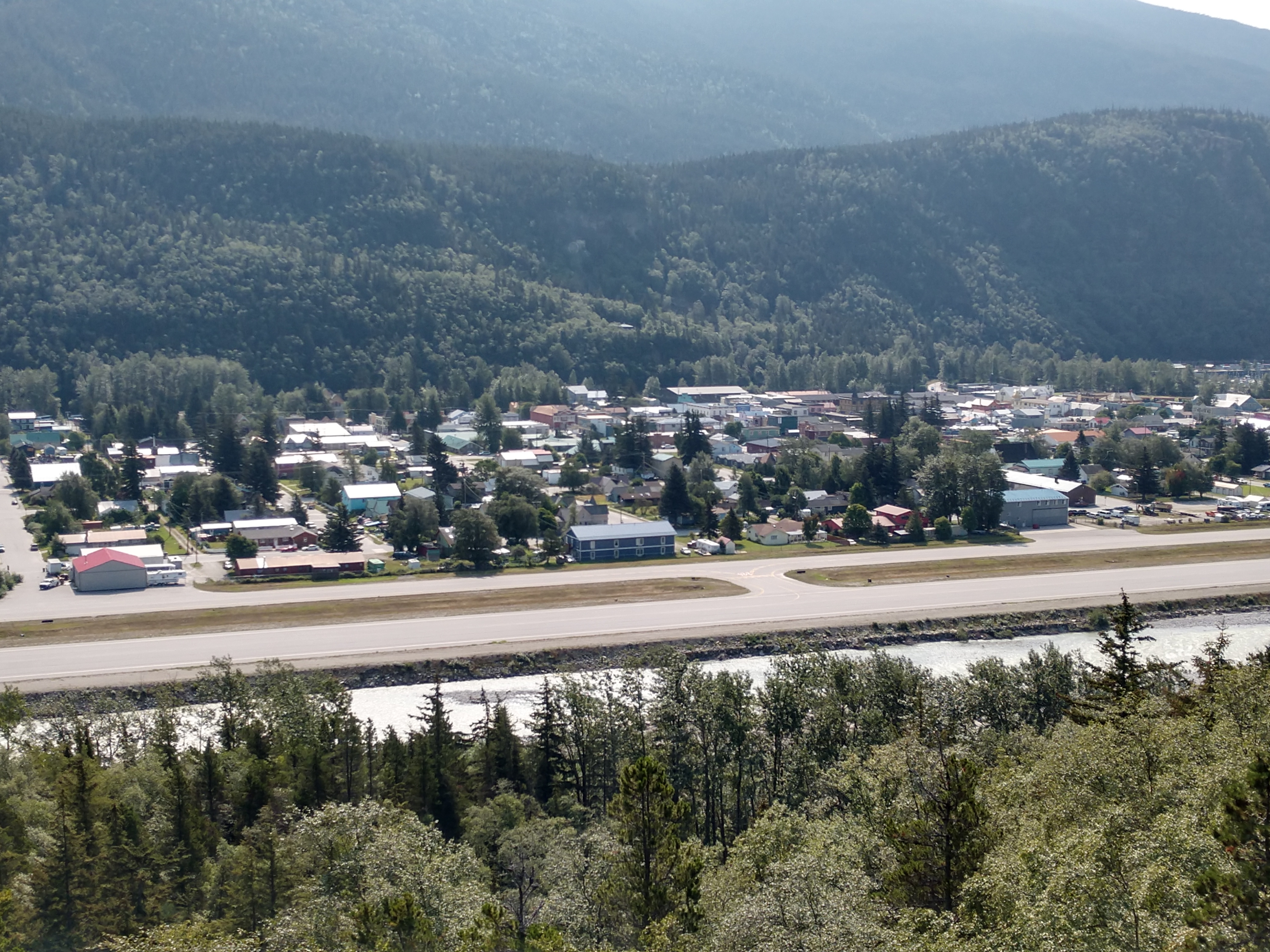
For a birds-eye view of downtown Skagway, the historic harbor, and the surrounding snow-capped peaks, we took the scenic drive along the road to Dyea and stopped off at the Skagway Overlook on our way back to admire the views. From the viewing platform, there are great panoramic views of the historic Gold Rush-era town, Skagway and the narrow Taiya Inlet, which connects Skagway to the rest of Alaska’s Inside Passage.
Perched high up on the hillside, we saw the magnificent views of Skagway, the Lynn Canal, and the Twin Dewey Peaks. As we looked out across the narrow Skagway valley, it was easy to see just how small and compact Skagway really is. Skagway has a winter population of 600-700 people and a summer population of close to 3,000 people. With only 4 streets that run the entire length of town and 23 cross streets, this town has seen a lot since its beginnings in 1897. The tallest peaks opposite side of the valley are around 5,200 feet tall.
Notice that there are three distinct plateaus or tiers as your eye moves up the mountain. These were carved out by 3 periods of glaciation. Atop the first plateau is Lower Dewey Lake, and farther up near the top is Upper Dewey Lake. Both are accessible by a hiking trail, but both trails are considered strenuous and difficult.


From this outlook, we could also the cruise ships in the Port of Skagway today.


After we left the Skagway Overlook, we drove back into Skagway and followed the sign to the Gold Rush Cemetery. This is the oldest cemetery in Skagway and the easiest to visit. This was the first cemetery for the City of Skagway and many of the famous Gold Rush characters are interred here including local kingpin, Jefferson "Soapy" Smith and the early tourism promoter, Martin Itjen and his "world's largest gold nugget."

The cemetery contains the graves of people buried in Skagway in the late 1800’s and early 1900’s which encompasses the gold rush time period. Most died in Skagway, but some died in Dyea, Haines, or on the Chilkoot Trail. In more modern times, people have tried to save the historic information painted on the gravestones and found in old records. Some information has been completely lost, but the majority of grave markers have names and dates.

The cemetery is located on a hillside, among the trees. It’s a pretty setting, and you can wander among the graves, reading names and other inscriptions. While it’s sort of a somber place, there was nothing creepy about it.

An informational sign at the entrance to the cemetery (shown above) explains the stories of some of the more notable graves. For example, Jefferson “Soapy” Smith was a local con man. He won a large amount of gold from a man in an illegal game of three card monte. Considering Soapy Smith’s reputation, it was probably rigged. The man refused to pay, and Smith and his friends grabbed the gold and ran. They later had a confrontation with a group of vigilantes determined to bring down Smith and his gang. Both Soapy Smith and Frank Reid, one of the vigilantes, were mortally wounded in the confrontation, though it is unclear whether each shot the other.

(We used the above map to help us find some of the famous historical graves in the Gold Rush Cemetery.)
You can find both of these graves -- Soapy Smith and Frank Reid -- in the cemetery. Smith’s is a small marker with his name and dates of birth and death. Below is the story about him that makes him famous.

(Above is a photo of Jefferson Randall "Soapy" Smith, while below is his gravesite.)


* * * * *
Reid’s grave is much larger and made of marble. Inscribed on it are the words, “He gave his life for the honor of Skagway.”

(Above is a photo of Frank H. Reid, while below is his gravesite.)

The story about Frank Reid is shown below.

* * * * *
There were also a couple of unknown cemetery plots (see below), and the story of one of the "unknowns" follows.


* * * * *
The story behind Martin Itjen follows:


These signs about Martin and his wife Lucy in Skagway’s Gold Rush Cemetery say it best.

(Above is a photo of Martin Itjen, while his and his wife Lucy's graves are shown below. Note the large gold nugget behind the graves.)


Martin Itjen arrived in Skagway, Alaska in 1898, on his way to the Klondike gold fields. Born in Europe, he was living in Jacksonville, Florida when the local newspaper boasted headlines of gold discovery in the far north Yukon. He ventured to the shores of Skagway, learning along the way of requirements set by the Canadian Mounted Police to carry 2,000 lbs. of food and provisions over the coastal mountain range and continue another 600 miles north to Dawson City. Skagway was a boom town with a rapidly flourishing economy. Upon his arrival there, Martin decided to postpone his plans to continue to the goldfields and took a job with the White Pass Yukon Route Railroad as a track layer.
Over the next few years, Martin tried his hand at several other endeavors. He served as the town's first undertaker, worked as a carpenter, and delivered coal. In 1902, Martin and his wife Lucille, opened the Bay View House, which was a hotel room built onto a scow. It was an original structure, near the Moore's wharf where lodgers could rest for $0.25 a night.
During the 1910s through the 1930s, tourism began streaming into the Alaskan coast. More and more tourists replaced gold seekers, making the journey to see the natural beauty. Martin greeted the town's visitors down by the marina offering a guided town tour complete with his personal accounts of the Days of '98. His love of the automobile and the tourist industry evolved together to form the Skagway Streetcar Company. He developed a narrated tour that kept stories of the Grand Adventures of the Gold Rush alive. He published a booklet to accompany the tour complete with Itjen's original poetry:
"If you're going to the Klondike I'll tell you what to do,
Be sure you take a ton of grub,
Or better yet, take two.
For you'll find that you'll be hungry,
Morning, noon and night,
And you'll soon have what the people
Call a Klondike appetite."
Business went very well for Martin as he shared the lore of Skagway with his wit and humor. He built four streetcars over the course of his life, each a little different than the other. On the exterior of one of his vehicles, he attached a small mechanical bear he had created himself. When Martin took a right hand turn, the bear would signal by lifting his right paw, same to the left. A life-size mannequin of con man, Soapy Smith, stood on the back of one of the streetcars with a large cigar in his mouth. Martin rerouted the vehicle exhaust to come up through Soapy's body and out the cigar. Martin used these novelties added excitement to his tours, which cost 50 cents and lasted 2 hours.
In 1935, Martin embarked on a well-documented road tour in one of his street cars along the west coast. He met famed actress Mae West in Hollywood and gained national media attention. He showcased his street cars and shared stories of his gold rush adventures in Skagway. Upon his return Martin continued operating the Skagway Streetcar tours and a year later began early restoration of Jeff. Smiths Parlor Museum. The museum was a celebrated stop on the streetcar tour and preserved gold rush era memorabilia that is still in existence today. Martin Itjen is remembered as the premier leader of Skagway tourism and remained a tireless Gold Rush promoter until his death in 1942. Martin and Lucy Itjen were the last people buried in Skagway’s Gold Rush Cemetery.
* * * * *
We also read about a young newlywed couple, Bert and Florence Horton, who were murdered. Bertram "Bert" Horton (age 27) and Florence "Flora" Oliver (age 18) were married in Eugene, Oregon on February 27, 1899. He was a butcher by trade and she was a devout member of the Episcopal Church. The young couple opted for a "working honeymoon" in Alaska and arrived in Skagway on March 7, 1899.

(Bert and Florence Horton's graves are shown above and the story about them is below.)

The Horton's quickly found jobs in a small eatery near the summit of the White Pass Trail between Skagway and Lake Bennett, and worked there all summer. In October, they decided to do some leisurely camping on Lynn Canal before heading back to Oregon. They must have not known how dangerous it might be to camp in Chilkat territory, because one week later, they were both dead.
In the Chilkat culture, reprisal killings were not only justified, but they were a tradition. A "death for a death" running tally was taken very literally. For example, the search party believed that the Horton's had killed three Indians, therefore the Indians had the right/responsibility to kill three white people, no questions asked.
The next morning, the Indians paddled across the channel towards the Horton's camp. Once on shore, Qualth's wife Quiee, Paddy Unahootch and "Goos" White stayed with the canoe while the other nine men walked towards the newlyweds. As they approached, Bert Horton came out of his tent and tried to wave them away with his rifle, but they ignored his warning and kept coming.
Without hesitation, Qualth took aim and shot Bert Horton in the head, killing him instantly. Mrs. Horton started screaming for her husband and Jim Kitchtoo shot her twice, once in the face and once through the upper chest. As she lay dying and begging for her life, the Indians circled around her and 17 year old Jim Williams reached down and slit her throat, nearly decapitating her. The savage killings were over in seconds.
The Indians went through the newlyweds possessions and took a Winchester rifle, a double barrel shotgun, a watch, some money and Mrs. Horton's jewelry. Next, they dismantled the couples tent, wrapped the dead bodies with it, and buried them in a deep hole behind some boulders near the high water mark on the beach and covered the grave with rocks and tree branches.
The Indians made a pact with each other. If anyone in the group confessed to killing the Horton's, the rest of the group would band together and tell the authorities that the confessor was the lone killer.
Back in Skagway, friends of the newlyweds were beginning to worry because the Horton's had not returned from their camping trip. Hypothetical scenarios were tossed back and forth daily -- maybe they didn't come back because they had flagged down a passing steamer or maybe they decided to go north in search of gold or maybe they wrecked their boat and were on foot or maybe they were killed by the Chilkats. Eventually, a search party was sent out to the Sullivan Island area, but no signs of the young couple were ever found.
* * * * *
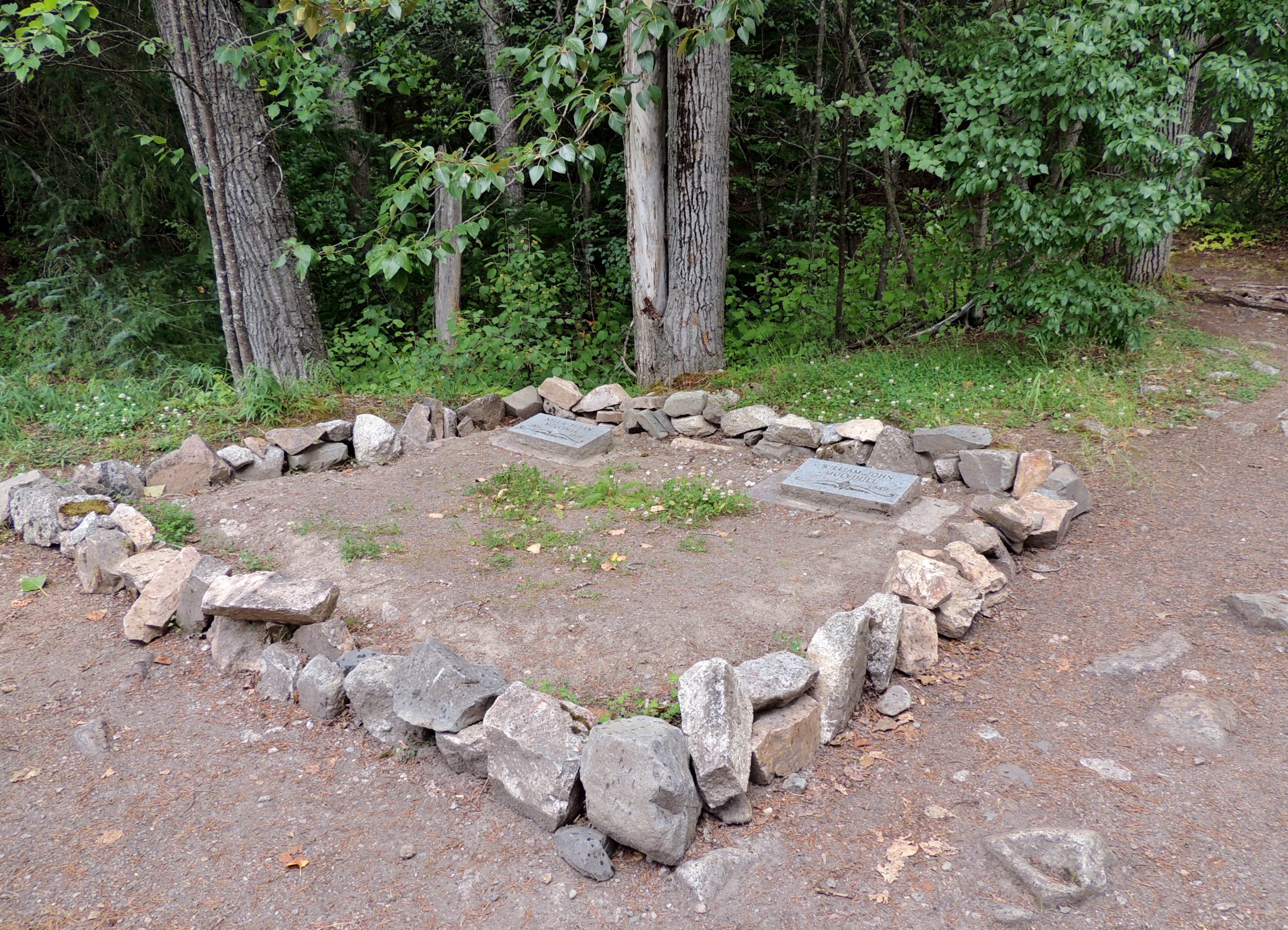
It is no accident that the closest gravesite to the railroad track belongs to W. J. "Mull" Mulvihill, and to his wife, Nellie.


Shortly after the railroad tracks were completed from Skagway to Whitehorse, William Mulvihill "Mull" became a dispatcher in Skagway. Before long he was promoted to Chief Dispatcher, and moved into the ornate house at Seventh and Alaska. At the now restored Mulvihill House he had the dispatcher telegraph line connected so he could keep tabs on the trains even while at home.
In 1942 "Mull" retired from the railroad with 40 years of service. His descendants still take a great interest in the affairs of historic Skagway and its gold rush railroad.
* * * * *
It is undeniable that vice played a big part in the gold rush days of Skagway. Saloons, gaming halls, and prostitution were revenue machines. Women in the sex industry came from all walks of life. Some professional women followed the migration of thousands of stampeders and their money. Being abducted into sex trafficking was common, forcing women to work as prostitutes against their will. Some women arrived in Skagway with husbands or family who either died or deserted them. With few options to support themselves, one way to make money was prostitution.

Above is Ella Wilson's grave, while below is the story about her.


Ella D. Wilson was an African American sex worker living in Skagway. Her profession was one of the most dangerous a woman could have in the gold rush. In May 1898 Ella transitioned from a citizen to a statistic when she was found dead. The cause of death was murder. They discovered Ella in her bed, a pillowcase over her head and a gag in her mouth. Her wrists and ankles were tied together, her money and jewelry missing, her trunk rifled through. Next to her bed, nothing except a pair of rubber boots and a pistol. Everything pointed to a robbery gone wrong.
Here was a newspaper article that was printed about her death in the Morning Oregonian on June 4, 1898:
"SMOTHERED TO DEATH -- Mysterious Murder of a Mulatto Woman in Skagway occurred last night. Ella D. Wilson, a mulatto woman, was smothered to death in her house on one of the busiest streets of the town by some unknown person. The murder was not disclosed until this afternoon. The woman was found lying in her bed. Around her neck a pillow-case had been drawn tightly, with the ends thrust in her mouth for a gag. Her wrists and ankles were tied together with sheets. Over her head and face a pillow was pressed down, and death had evidently resulted from smothering. Robbery is supposed to have been the motive for the crime, as the woman’s trunk had been rifled. She was thought to have had about $2000. There is no clue to the murderer. The murdered woman had lived in the principal towns on the Pacific coast. Rumor had it that Ella had $2,000 dollars in her possession (roughly $60,000 in 2016). A well-known madam from Denver, Mattie Silks, accused the notorious Skagway con-man Jeff “Soapy” Smith as the one responsible for Ella’s death. In lawless Skagway, nothing came of this accusation. Just five weeks later, Soapy Smith died in a shootout. To this day the murder of Ella D. Wilson remains unsolved."
Ella may be gone, but she is not forgotten. Her final resting place is the Gold Rush Cemetery. Located at the north end of Skagway this is a well visited point of interest. Interred at the base of Reid Falls are famous and colorful characters from Skagway's gold rush days. Ella's grave is just a few dozen feet away from the grave of the man accused of murdering her, Soapy Smith.
* * * * *

Above is the grave of H.C. Parker, who died March 28, 1900 and is buried in the gold Rush Cemetery in Skagway.
While attending a Chamber of Commerce meeting, Henry Clay Parker collapsed from a heart attack. Heart failure was often listed as the cause of death in early Skagway. It may be presumed that many of these people died of other causes. Medical personnel were overworked, and often without sufficient experience to diagnose more complicated ailments.
Mr. Parker's funeral was one of the most unique ceremonies in Skagway's history. As the first member of Camp #1 Arctic Brotherhood to die in Skagway, Parker's funeral was conducted by the Brotherhood. A special train took the funeral party and guests from the Arctic Brotherhood Hall to the end of town. From there wagons carried the group to the cemetery.
* * * * *

The cemetery database states that Clara Amelia Patton was born in February 1875 in Washington State, and died in Skagway of blood poisoning on December 14, 1905. (See her grave above.)
* * * * *

The grave of Deputy U.S. Marshal James Mark Rowan is shown above. He was a hero to not to be forgotten! Skagway has been the plot setting for many a novel such as, "Call of the Wild" and "White Fang" by Jack London. Little would a kid, whose father died when she was eleven, imagine the history and legacy of her great grandfather, James Mark Rowan, during the Gold Rush of Alaska. But this is the story she has told of James Mark Rowan's death:
Marshal James Mark Rowan journeyed west of his hometown of Rogersville, Tennessee. One of his stops along the way was Mt. Vernon, Washington, where he served as a city marshal and married his future wife, Beryl Grove. In August of 1897, James and Beryl Rowan moved to Alaska where they were one of the first people, just after Frank Reid, to buy a plot of property in Skagway. James Rowan also helped build the Brackett Wagon Road from Skagway to White Pass City.

Less than six months after settling in Skagway, and working primarily in Dyea, Marshal Rowan was asked to work in Skagway while Marshal McInness was escorting prisoners to Sitka. Skagway was a boomtown, complete with dance halls, gambling, brothels and all the degradation that accompanies dishonorable behaviors. It was not uncommon for bartenders to short change customers and have an argument ensue.
On January 31, 1898, Marshal Rowan and his wife experienced the greatest joy and the worst sorrow one could imagine: the birth of his son, and Marshal Rowan dying in the line of duty. Two hours after giving birth to their son, James Mark Rowan, his wife Beryl needed medical attention. Marshal Rowan sought Dr. Moore, but was intercepted by Andy McGrath who had been short changed and beaten by Jake Rice, the owner of the People’s Theatre, a known brothel. When McGrath and Rowan entered the People’s Theatre, Ed Fay, who was behind the bar and was prepared for McGrath’s return. What he was not prepared for was that McGrath would return with the law!
Upon entering the Theatre, Fay encountered an angry McGrath. Fay either did not recognize or didn’t care that Marshal Rowan had accompanied McGrath. Fay reacted to McGrath, thinking he was armed. Fay shot the “unarmed” McGrath and then fatally shot Marshal Rowan.
The story of what happened to his wife, Beryl and young son, James Mark Rowan has been somewhat fractured. Rowan was buried in the Gold Rush Cemetery on February 4, 1898. A small wooden marker was placed above his grave. It listed his age, 33, and date of death, nothing more. Beryl remained in Skagway at least through the 1900 census, but had moved to Seattle, Washington by the 1910 census. On July 4, 2010, the U.S. Marshals Office re-commemorated the service of Marshal Rowan in Skagway, Alaska with a new grave marker, in his honor, that was placed in the Gold Rush Cemetery.
* * * * *

Rev. Archibald John Campbell was born in Scotland on February 13, 1834 and died in Skagway on February 22, 1899 (see grave above). The story and circumstances behind his death follow:
In February of 1898, Archibald John Campbell came to Skagway to be the Episcopal Minister and dubious doctor. Then when Presbyterian Minister John Sinclair came to Skagway in 1898 from Ontario, he found that the Reverend Doctor Campbell was firmly ensconced in the Union Church that had been built in 1897 by Rev. Dickey.
Campbell did not welcome Sinclair and told him the Union Church was Episcopal and refused to move out. Sinclair had been sent by Bishop Rowe because of odd allegations against Dr. Campbell. Campbell was later fired by Bishop Rowe because of allegations of misconduct with females by a neighbor, George Aggers.
Aggers and others said women were seen coming and going from the Reverend’s home at all hours of the night. The women supposedly were coming to Dr. Campbell for his famous internal massage or liver therapy. After some months of dispute, Campbell moved to a cabin on the hillside where he apparently was quite agitated and died on this day, February 22, 1899 of a heart attack.
* * * * *

Mrs. McMullin died on February 27, 1899. That is all we know about her.
* * * * *


James Kenny was born in Prince Edward Island, Canada on February 8, 1876 and died on February 8, 1900. (See his grave above.) He died of heart disease. This was a ballad written about this young man that found himself trapped in a place in time:
My name it is James Kenny, as my tombstone does proclaim. And you have traveled all this way, to stand upon my grave.
I am cursed to tread this rocky path, since those heady days of old. When many walked the Chilkoot pass, with a thirst for Klondike gold.
I came here with my father, far from our Island home. To seek our share of fortune, in this dreary land of cold.
I am but one of many, who held no pick or pan. But lost his soul to gold dust, washed out from river sand.
And so I died here lonesome, a broken hearted boy. Buried by his own poor father, who lost his pride and joy.
We came from many places, leaving all we knew behind. And I have left my mother, who on her pillow cried.
Say hello to Harley Baker, Soapy Smith and John Malone. For each day they walk the pass with me, and each night they rest alone.
We a weary band of spirits, who in truth are strangers still. For we march in silence each long day, then return to Gold Rush hill.
Take warning all you foolish men, who long for danger found. You’re like me and my companions, lying in a burial ground.
I climb a path each evening, to rest here in the clay. I am doomed to walk tomorrow, until the end of days.
* * * * *


Duncan B. McFadden died June 6, 1898 (see grave above). He was born in Cape Breton in 1850. In 1882, Duncan McFadden and his wife built a house and blacksmith shop on the main road across from the Knox Hotel. He died of meningitis at the age of 48.
* * * * *
The cemetery also contained the graves of people who died of tonsillitis, hypothermia, and sometimes violence. Sadly, a number of children were buried here as well. Together, they all helped paint a picture of what is was like in Skagway during the days of the Gold Rush. Hazel Achison was one of the children that died in Skagway from an epidemic. Her grave is shown below.

The story of what happened to Hazel is shown below:

* * * * *

(Note the locations of Gold Rush Cemetery and Lower Reid Falls on the map above.)
Located also within the Gold Rush Cemetery was Reid Falls. To hike to Lower Reid Falls, keep to the right and follow this sign…

Below is the path to Lower Reid Falls, which is just a few hundred feet above the Gold Rush Cemetery.

The short hike takes you uphill through the forest to the falls -- which cascades 300 feet down the mountainside. The falls are named after Frank Reid, who killed the gangster Soapy Smith in July, 1898.

(Lower Reid Falls is definitely worth the short hike.)

.jpg)
.jpg)
(Selfie of Mel at Lower Reid Falls.)

After the falls, I took a couple of pictures looking back out toward Skagway from the Gold Rush Cemetery.


Then we drove back into Skagway to get a smashed penny for our son, Ben at the Kone Kompany (see picture below).

Kone Kompany has the sweetest treats, including incredible handmade fudge. Since I had a coupon (buy two 1/4 pound pieces of fudge for $5 each, and get a third piece of fudge free), we decided to indulge. It sure was yummy! (See below.)

Another historical building in Skagway that we didn't see yesterday was the Y.M.C.A Gymnasium. The storyboard below told us about it.

The YMCA Gymnasium in Skagway was founded in 1898 by Michigan native, William Reid, who was headed to Dawson, Yukon Territory, to start a branch there. Difficulties on the Chilkoot Trail kept Reid in Skagway where he set up a tent and established the first YMCA in Alaska.
The organization operated out of the Presbyterian Church and by 1900 boasted a membership of almost 1,000, prompting the YMCA to contract with G.N. Hensley to construct a gymnasium. The YMCA operated the gymnasium until 1902 when its membership declined following the waning gold rush. The Carstens brothers, proprietors of the Arctic Meat Company, purchased the building and moved it forward to front State Street and connected it to the Meyer Building (1899).
The Carstens converted the gymnasium to a cold storage facility and operated the Arctic Meat Company until at least 1909. In 1921, George Rapuzzi purchased the gymnasium from the City of Skagway, which had taken ownership. In 1922, Rapuzzi bought the Meyer Building from the Carstens and used both buildings as a garage and later storage. The Rasmuson Foundation of Anchorage purchased both buildings and donated them to the National Park Service in 2008.


The original Y.M.C.A gymnasium (on the left above) and the Myers building (on the right above) are currently being restored by the National Park Service as you can see below.


Alaska Commercial Company (shown above) is a retailer that provides groceries and general merchandise in stores throughout rural Alaska. We stopped in and took a look inside.

Mel poses by a totem pole outside a museum in Skagway.

The Pantheon Saloon was built as a plain board-and-batten hotel in 1897. After briefly being used as a hotel, the building served as a hardware store. It is most notable for its Rustic storefront, added in 1903 when it became the Pantheon Saloon and a substantial addition increased its size from 18 feet by 28 feet to 21 feet by 48 feet. Charles O. Walker, who had designed the Rustic front of the Arctic Brotherhood Hall, designed this one, which features driftwood logs as columns and cobblestone sections of wall, as well as the driftwood-stick decoration seen on the Arctic Brotherhood Hall.
The building has been altered frequently. The double doors of the Pantheon were replaced by a single door, and some of the cobblestones were removed to enlarge the show windows. A 23-foot-wide building was added to the south in 1943. Yet the unusual Rustic storefront, hailed as “artistic” when constructed, remains.

The Pantheon and the 'Red Front Building' in Skagway, Alaska. The Pantheon, originally a saloon, is now operated by the National Park Service as an activity center for Junior Rangers.
And finally, we stopped at the Skagway Outlet (shown below) to buy a couple of t-shirts.

Below are the t-shirts we bought -- Mel's is the maroon one, while Shirley's is the mustard yellow one.

Before heading back to our camper, we stopped at Skagway Brewery for Mel to have a craft beer. We then went home and Mel fixed pizza for dinner.
We had an avalanche of fun today!
Shirley & Mel


No comments:
Post a Comment