Shown above is the Tin Cup Store. It is an essential stop if you make it up to Tincup. This building dates back to the 1800s and now operates as a small souvenir shop.
Shown above, Mel is airing down the tires in preparation for our journey to Tin Cup Pass, while shown below is Mike, Judy and Mel in front of the Tin Cup Store.
Shown above is Mike, Shirley and Mel in front of the Tin Cup Store.
Shown above is Frenchy’s Cafe on the Pond. Frenchy’s Cafe sits on a small fishing pond in town and is a great gathering place for visitors. It is seasonally open from June to September.
Driving through town, we went past the Tin Cup Town Hall that was built in 1903. It also serves as the church (see pictures below).
We're now heading for the Tincup Pass trail. We will see how far we can go before hitting snow (see map below).
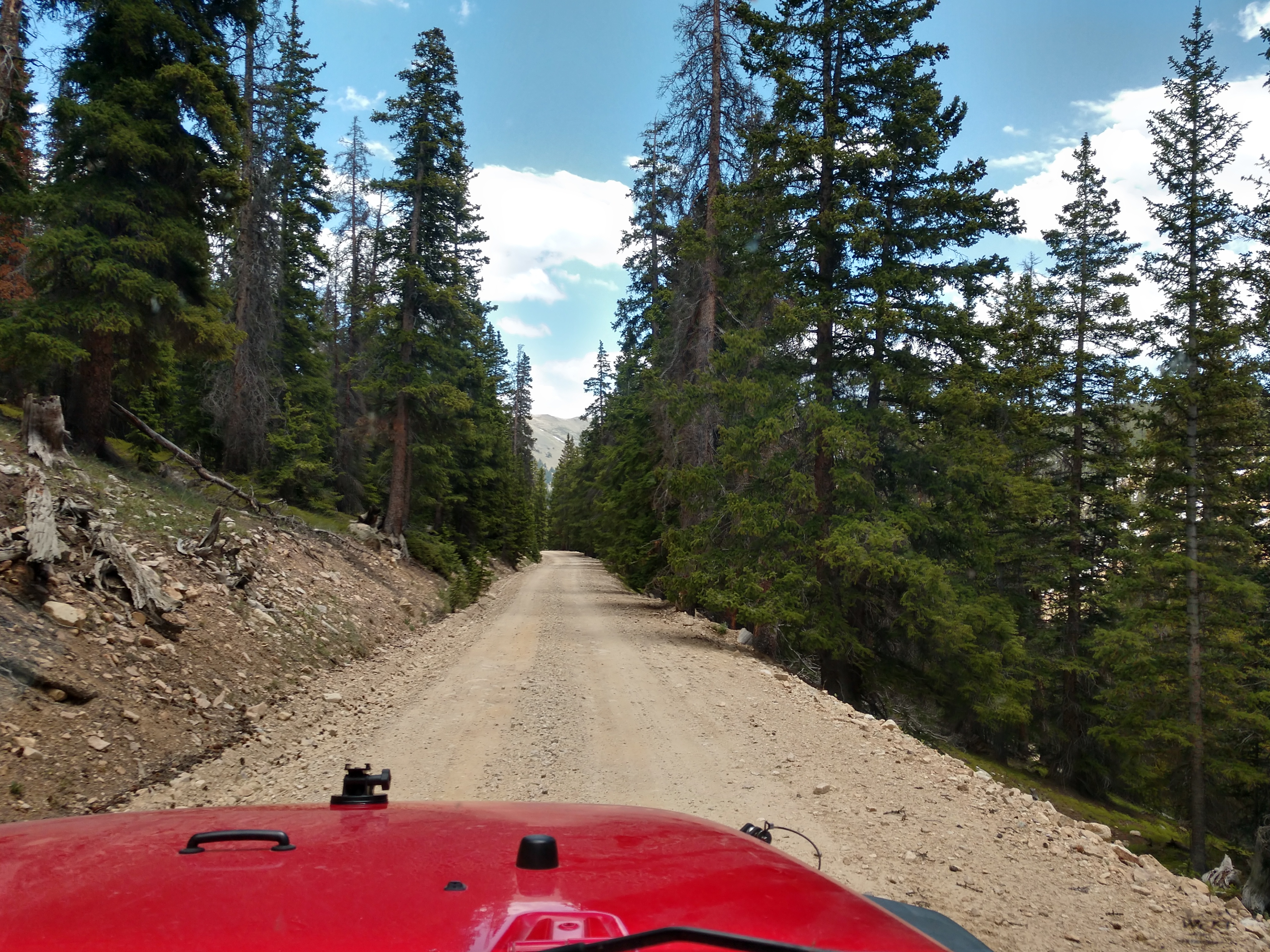
We followed Mirror Lake Road, which was a gravel and pretty rocky road.
It is now 3 miles to Mirror Lake and 7 miles to Tincup Pass.
As you can see in the above picture, the road is getting rougher with several bigger rocks and boulders that Mel has to watch out for and miss as he drives along.
We are now at the entrance to the Gunnison National Forest campground right before we come to Mirror Lake.
We can now see Mirror Lake in the distance (see pictures below).
At Mirror Lake, the 13,000 foot peaks of the Sawatch Range provide a dramatic backdrop for this site (see pictures above and below).
At the base of Tincup Pass, nestled amidst the grandeur of the Sawatch Mountains is the serene Mirror Lake. This natural oasis offers an unforgettable panorama, where the rugged mountain peaks meet the calm, reflective waters of the lake. Named for its mirror-like surface, the lake provides a picture-perfect reflection of the surrounding landscapes.
Shirley and Judy are standing in front of Mirror Lake. What a spectacular and beautiful lake it is!!!
This is another chance for Pedro to explore the surroundings. Pedro is resting in the grass (see below).
Shown below are Mike, Judy and Mel in front of Mirror Lake.
Today on the jeep trail, we could only go as far as Mirror Lake because of the high level of the water -- and therefore we were unable to drive around it and continue on. Instead, we decided to turn around and go back along Hwy 765 over Cumberland Pass to Pitkin.
Cumberland Pass is 9 miles away, while Pitkin is 20 miles away.
We're beginning to see some snow along the road to Cumberland Pass.
Actually there is quite a lot of snow!
We have now arrived at Cumberland Pass. Cumberland Pass has an elevation of 12,015 and is a high mountain pass in the Sawatch Range of the Rocky Mountains of Colorado. It is located in Gunnison County within the Gunnison National Forest. The pass divides the watersheds of West Willow Creek to the north and Quartz Creek to the south.
The pass is traversed by Forest Road 765 and can be accessed from the towns of Tin Cup to the north and Pitkin to the south. The road is gravel and is closed seasonally due to heavy snowfall, typically from November until May.
The Cumberland Pass road was built in 1882, connecting the mining towns of Tin Cup to the north and Pitkin to the south. The wagon road allowed ore from Tincup-area mines to be shipped to the Quartz Station of the Denver and South Park Railroad. The ore was then shipped by rail east through the Alpine Tunnel. The road was later improved by the Civilian Conservation Corps in 1935 and improved again in the 1950s.
Since there was quite a lot of snow up here at Cumberland Pass, Mel decided to drive the jeep into a snow bank just for the fun of it and because he could (see below).

Both Mel and Mike got out of the jeep to stomp around on the snow drift.
Mike found a beer bottle and picked it up, while he was enjoying the nice view!!!
After stretching our legs and taking what pictures we wanted, we began our descent down from Cumberland Pass toward Pitkin.
The road wasn't too bad, but the views were spectacular!!!
We saw many running creeks and waterfalls along the way.
We drove into the turnoff for the Alpine Tunnel, but found it was closed so we continued on.
The sign shown above indicated we are now 3 miles from Pitkin.
Welcome to Pitkin! Pitkin has a population of 72 and was founded in 1879. It is said to be Colorado's first mining camp west of the Continental Divide. Originally named Quartzville, it was renamed to honor Governor Frederick Walker Pitkin. Pitkin is at an elevation of 9,242 feet, and located about 28 miles northeast of Gunnison, Colorado.
Shown above is the community of Pitkin. Surrounded by the Gunnison National Forest, Pitkin is a quiet mountain town. There’s a main street and many historic buildings around town. It’s a semi-ghost town, with not much open except during the warmer months of the year.
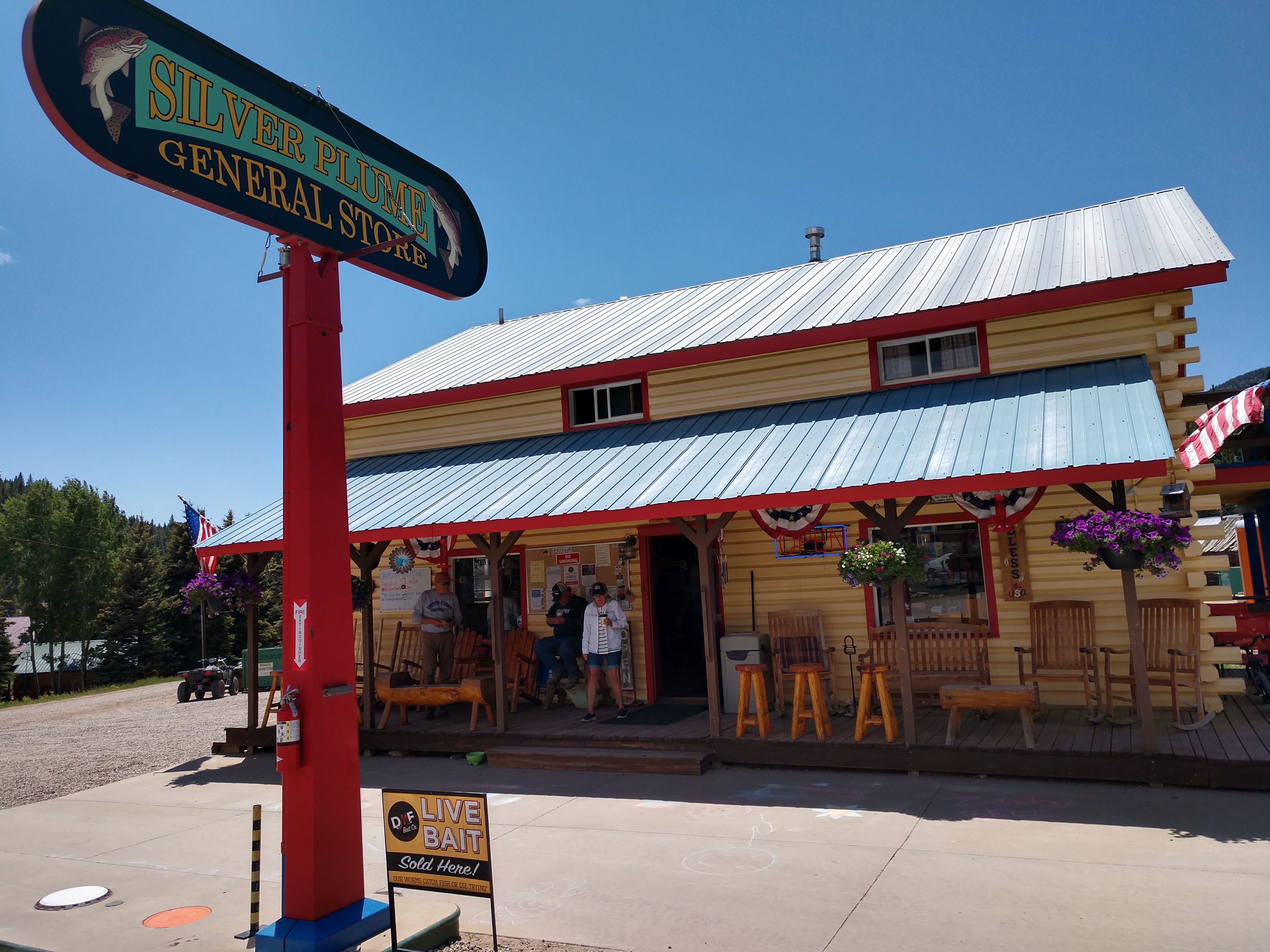
The Silver Plume General Store (shown above) is located in the town of Pitkin, Colorado. We stopped there for a restroom break and another opportunity to walk Pedro.
Mike, Judy and Mel poise in front of the Silver Plume General Store alongside the wooden-carved bear. Note that the bear's mug says, "Pitkin and a-grinnin."
And then just as we were leaving Pitkin, we saw this beautiful stagecoach with horses.
Wednesday, June 19, 2024
It's another beautiful day here at the campground.
As shown above and below, these are the fabulous views we have looking out our RV door from our campsite!
Around mid-morning, Mel, Mike and Judy rode their bikes out to the bridge closing at milepost 138.
Shown above is Mel on his bike in front of the Blue Mesa Reservoir.
Shown above is Mel and Mike riding to where the road is closed, while below is Judy stopped on the road.
For dinner tonight, Judy fixed a fantastic spread of chicken fajitas with all the trimmings (see below). They were simply delicious!!!
So far, we have enjoyed every minute of our time in the mountains!
Shirley & Mel


.jfif)


.jfif)
.jfif)
.jfif)
.jfif)
.jfif)


Tin Cup is beautiful. Looks like you all had a great time. Love this blog. 😀
ReplyDelete