Monday, March 18, 2024
Today started out cloudy with a few sprinkles. The temperature ranged from 64 to 71 degrees. We left the campground at 9:30 a.m. and headed toward Joshua Tree National Park near Twentynine Palms, California.
As you can see from the above and below pictures, the skies were very cloudy and ominous looking.
Chiriaco Summit was now 9 miles away. Chiriaco Summit is a small unincorporated community and travel stop located along Interstate 10 in the Colorado Desert of Southern California. It lies 19 miles west of Desert Center on the divide between the Chuckwalla Valley and the Salton Sea basin at an elevation of 1,706 feet.
The Joshua Tree National Park exit was next.
Twentynine Palms is a city in San Bernardino County, California. It serves as one of the entry points to Joshua Tree National Park.
Native American tribes such as the Serrano, Chemehuevi, and Cahuilla lived in the area. Colonel Henry Washington made the first recorded exploration of Twentynine Palms. He found Native Americans from the Chemehuevi tribe who lived in the surrounding hills and near the spring they called "Mar-rah".

Twentynine Palms was named for the palm trees found there in 1852 by Col. Henry Washington while surveying the San Bernardino base line. A post office was established in 1927. A road named Utah Trail honors the late 1800s pioneers on a trail originating in Utah (reportedly Saint George) that went to Twentynine Palms. Nearby is a small Indian reservation belonging to the Twenty-Nine Palms Band of Mission Indians.

Joshua Tree National Park, which lies just to the south of Twentynine Palms, was designated a national monument in 1936, and became a national park in 1994.
We were now 1 mile from Joshua Tree National Park.
We have now arrived at the entrance to Joshua Tree National Park.
As we drove into the Joshua Tree National Park, it began to sprinkle a little.
Joshua Tree National Park is where two deserts meet. Two distinct desert ecosystems, the Mojave and the Colorado, come together in this park -- where a fascinating variety of plants and animals make their homes in a land sculpted by strong winds and occasional torrents of rain!
Joshua Tree National Park is characterized by rugged rock formations and stark desert landscapes. Named for the region’s twisted, bristled Joshua trees, the park straddles the cactus-dotted Colorado Desert and the Mojave Desert, which is higher and cooler. Keys View looks out over the Coachella Valley. Hiking trails weave through the boulders of Hidden Valley.
Our first stop was the Cottonwood Visitor Center.
We went inside the visitor center, got a map of the park and asked some questions.
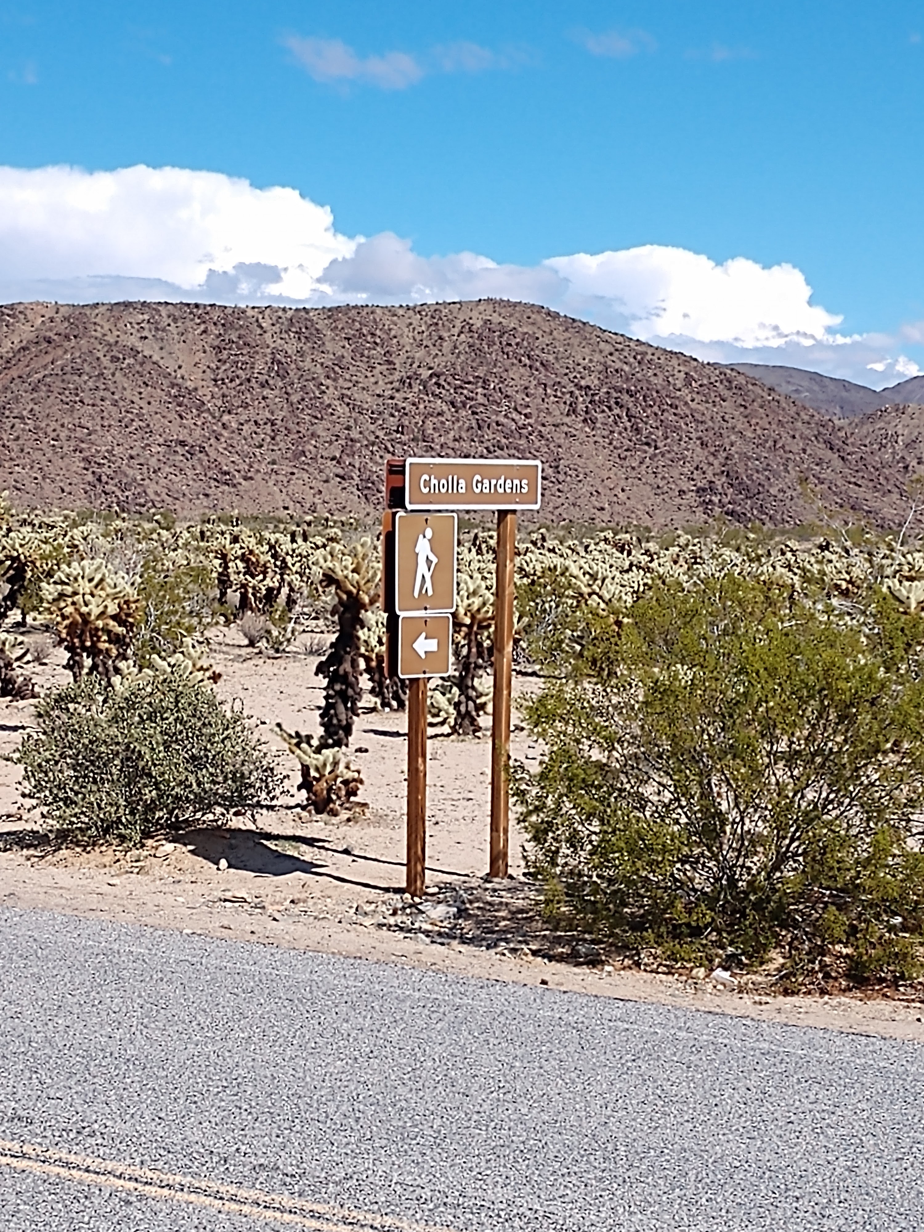
After we left the Cottonwood Visitor Center, we drove along the park road toward the Cholla Cactus Garden.
We were amazed at how much greener it was now in the desert than when we had last seen it in December 2020 when we were here.
We continued on along the Pinto Basin Road.
We were soon at the Octillo Patch in Joshua Tree National Park. Ocotillo Patch is a scenic pull off along Pinto Basin Road located between two mountain ranges in an alluvial fan, a place where sediments spread out from a narrow area often carried by water. This area gets more moisture from runoff to support more plants, including the high number of ocotillo that are located here (see picture below).
Ocotillo are one of easiest plants to identify in the desert. They are a large shrub with long cane-like unbranched spiny stems that grow from a short trunk. Small 2 inch leaves grow from the stems when there is enough moisture. Dense clusters of red tubular flowers grow from the end of the stems from March through June.
Our next stop was at the Cholla Cactus Gardens.
There was a sign warning us not to touch the cholla cactus. It’s a pretty amazing sight -- the cholla cactus looked very terrifying, just like a cactus that you would never want to mess around with.
We walked along the Cholla Cactus Garden Trail (see map above).
We hiked through thousands of teddy bear cholla cactus and enjoyed scenic mountain views. The Cholla Cactus Garden in the Pinto Basin, was part of the transition zone between the Colorado and Mojave Deserts. Cholla were concentrated here because of the right conditions for these plants to thrive and multiply. They mainly reproduced when detached stems rooted into the ground to grow a new plant. These separate stems were often too heavy for the wind to carry, so the colony grew in this garden!
The cactus garden had a short 1/4 mile nature trail that was definitely worth taking.
Shown above is Mel among the cholla cactus.
Shown above is Shirley among the cactus along the trail.
Notice in the above picture all the new segments of branches coming on the cholla cactus.
Even though it looked like a fire might have recently swept through the area burning the base of most of the Cholla in the garden, the truth was that this was natural and simply the dead spines of the Cholla cacti. None of these have ever been burned -- and even with the dark discoloration, the plants were healthy and continued to grow new stem segments. The segments would then drop off as the plant got older, which then produced a new plant.
Above Mel stops along the trail in the cholla cactus garden.
Again, we continued along the trail in the cholla cactus garden.
Above is Shirley in the cholla cactus garden with the mountains in the background.
There was a great quote on the information sign at the cholla cactus garden:
“If the plant bears any helpful or even innocent part in the scheme of things on this planet, I should be glad to hear of it.” — J Smeaton Chase
As humans, we often find value in other living things only when we see a profit for ourselves. We fail to recognize the value of a thing to itself or to other living things. The cholla cactus is one of these outcasts. But the desert woodrat or the cactus wren would undoubtedly have an eye-opening perspective to share.
The sheer concentration of the cholla cactus in this one area was breathtaking and certainly a sight to see. In many ways, they were just as impressive as the Joshua trees, just in a completely different way.
We continued along Pinto Basin Road.

We drove by White Tank Campground. This is small campground with 15 sites. There are pit toilets, picnic tables, and fire pits. There is no water available. RVs and vehicles with trailers may not exceed 25 feet.
Shown below is the White Tank Campground.
Shown below is the turnoff for the Arch Rock Nature Trail.
We drove by the turnoff to Arch Rock that we had walked to in December 2020. Arch Rock, at 30 feet wide, is arguably one of the best sights in Joshua Tree National Park. To get to this site, you need to park at the Twin Tanks Parking Area and then take a short leisurely stroll down a well-marked trail passing spiky Joshua Trees until you get to the grand Arch Rock.
Below is a picture of Arch Rock from our visit in December 2020.

Shown below was Heart Rock, definitely a most unusual and photogenic rock!
We continued along the road.
Leaving the Pinto Basin Road, we turned left onto Park Boulevard. Park Boulevard took us by many highlights, rock formations, and Joshua tree groves. Some of the top highlights along Park Boulevard included Hidden Valley, Cap Rock, Ryan Mountain, and Skull Rock. Short detours added stops at Keys View and Barker Dam.

Next, we passed the Live Oak picnic area (see below).
The Live Oak picnic area was nestled among rock formations along Park Boulevard about two miles west of its intersection with Pinto Basin Road. This picnic area provided a day use area with picnic tables and grills for people that wanted to enjoy a meal in the park.

We then continued on until we passed Skull Rock (that we had seen in December 2022 -- see picture below), so we didn't do the hike to this enticing boulder this time.
Skull Rock was one of the more unusual rocks in Joshua Tree National Park. Skull Rock was a boulder which resembled the top of a skull! The ‘skull’ shape was the result of two depressions in the stone caused by erosion but which somewhat resembled the eye sockets of a skull.
Jumbo Rocks Campground was 4 miles away.
Soon we drove by Jumbo Rocks Campground. In the heart of Joshua Tree National Park and just a short hike from Skull Rock, Jumbo Rocks Campground weaves through a valley of ginormous boulder piles to provide a classic Joshua Tree camping experience. All of the campground’s 124 tent and RV sites come with picnic tables, fire rings, and pit toilet access, though there are no services or potable water.
Jumbo Rocks Campground is shown above and below.
We continued along Park Boulevard.
We turned off the Park Boulevard onto a gravel road that took us around a loop of big boulders (see below).
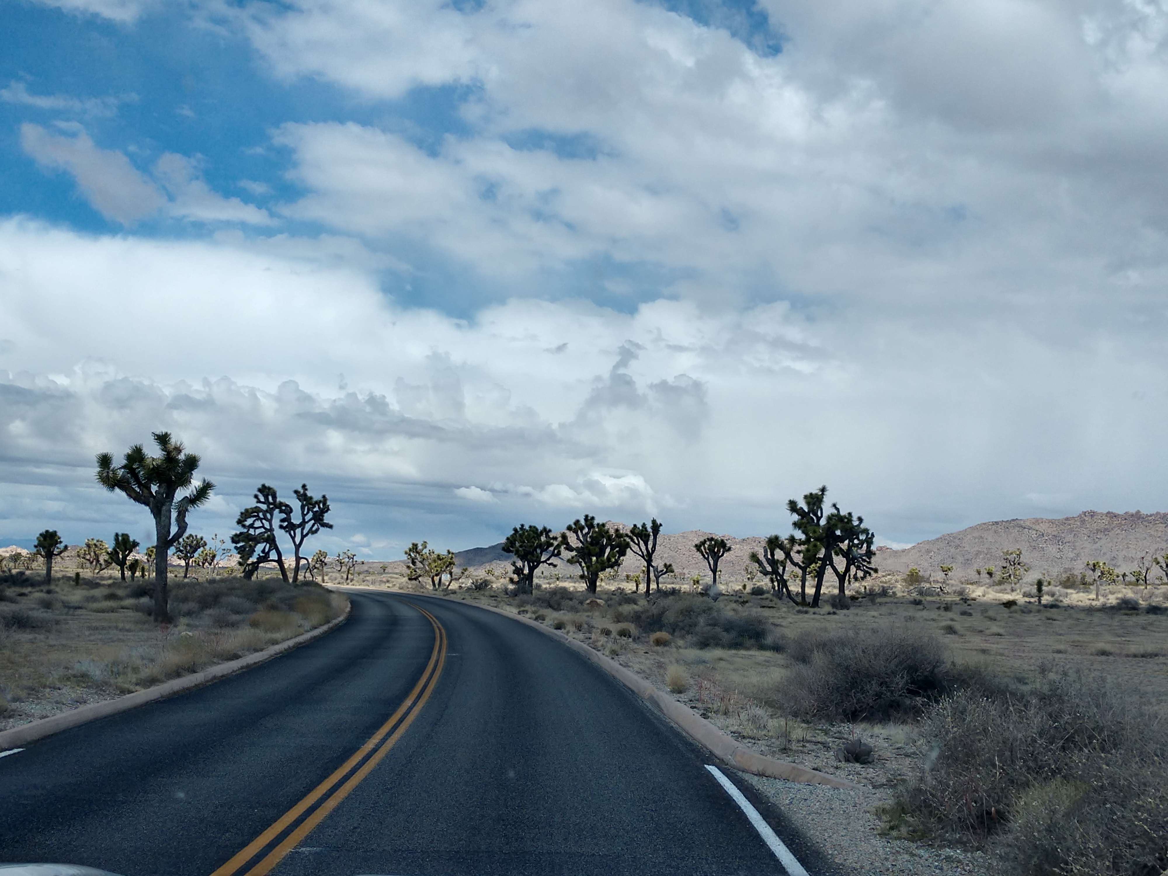
We then began to see Joshua trees (see above) in their many different forms. Sometimes they were full and bushy, other times spindly and open in their overall shape. We were surrounded by these twisted, spiky trees straight out of a Dr. Seuss book. In wonder, many travelers pulled over for a snapshot of this prickly oddity, while the naturalist reached for a botanical guide to explain this vegetative spectacle. And lastly, a rock climber may shout, “Yowch!” when poked by dagger-like spines on the way to the climbing route.
The massive boulders along the way were magnificient!
Known as the park namesake, the Joshua tree (Yucca brevifolia), is a member of the Agave family. Like the California fan palm (Washingtonia filifera), the Joshua tree is a very good indicator that you are smack dab in the middle of the Mojave Desert.


* * * * * * * * * *
HISTORY BEHIND THE JOSHUA TREES
Years ago, the Joshua tree was recognized by native people for its useful properties: tough leaves were worked into baskets and sandals, and flower buds and raw or roasted seeds made a healthy addition to the diet.
By the mid-19th century, Mormon immigrants had made their way across the Colorado River. Legend has it that these pioneers named the tree after the biblical figure, Joshua, seeing the limbs of the tree as outstretched in supplication, guiding the travelers westward. Some evidence suggests that Joshua trees inspired thoughts of the biblical Joshua in his role as a war leader. Perhaps the tree's sharp, blade-like leaves brought to mind the arrayed forces of Joshua's army.
Concurrent with Mormon settlers, ranchers and miners arrived in the high desert with high hopes of raising cattle and digging for gold. These homesteaders used the Joshua tree’s limbs and trunks for fencing and corrals. Miners found a source of fuel for the steam engines used in processing ore.
Today we enjoy this yucca for its grotesque appearance, a surprising sight in the landscape of biological interest. The Joshua tree’s life cycle begins with the rare germination of a seed, its survival dependent upon well-timed rains. Look for sprouts growing up from within the protective branches of a shrub. Young sprouts may grow quickly in the first five years, then slow down considerably thereafter.
The tallest Joshua trees in the park loom a whopping forty-plus feet high, a grand presence in the desert. Judging the age of a Joshua tree is challenging: these “trees” do not have growth rings like you would find in an oak or pine. You can make a rough estimate based on height, as Joshua trees grow at rates of one-half inch to three inches per year. Some researchers think an average lifespan for a Joshua tree is about 150 years, but some of our largest trees may be much older than that.
* * * * * * * * * *
Spring rains may bring clusters of white-green flowers on long stalks at branch tips. Like all desert blooms, Joshua trees depend on just the perfect conditions: well-timed rains, and for the Joshua tree, a crisp winter freeze. In addition to ideal weather, the pollination of flowers requires a visit from the yucca moth. The moth collects pollen while laying her eggs inside the flower ovary. As seeds develop and mature, the eggs hatch into larvae, which feed on the seeds. The tree relies on the moth for pollination and the moth relies on the tree for a few seeds for her young. Many birds, mammals, reptiles, and insects depend on the Joshua tree for food and shelter.


We have now left the dusty dirt road and have headed back on to Park Boulevard.
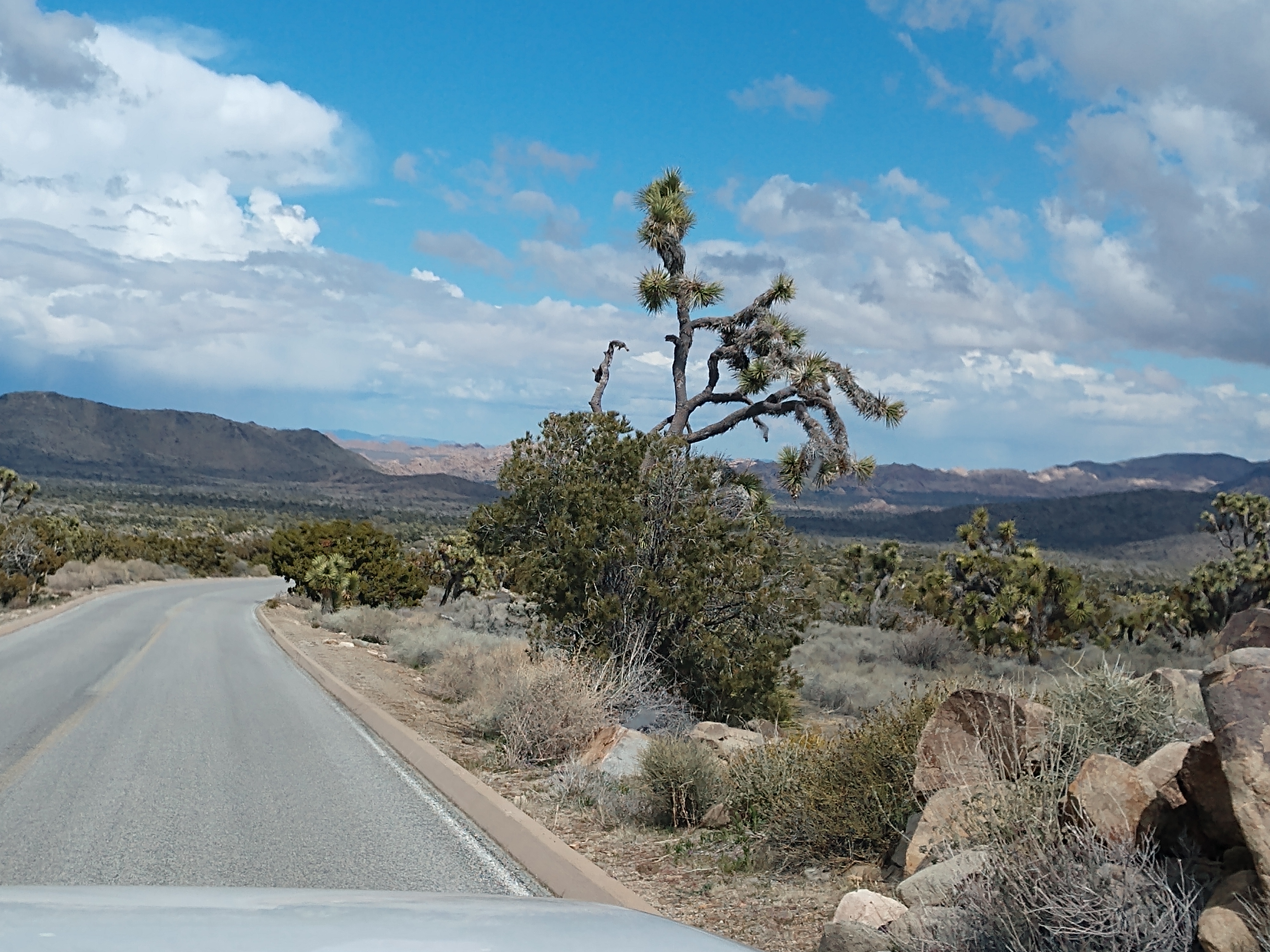
We continued to follow the road with its slight ups and downs, and curves along the way.
A couple more Joshua trees guided us along the route.
Here we saw a sign to Desert Queen Mine.
Going a little way up Park Boulevard, we turned right to follow the off-road toward Desert Queen Mine. Desert Queen Mine Road is a solid, fairly long road with basic washboard dirt conditions leading to the Pine City trailhead.
We followed the dusty road on for a ways.
After following the one-lane dirt road and going a couple miles, we came to the Desert Queen Mine trailhead and parking area for the hike to the Desert Queen Mine.
There was a bathroom at the trailhead, and the trail left from right next to it. Since the parking area was full, we decided not to stop, but turned around and went back toward the Park Boulvard.
Back on Park Boulevard, we drove past the sign for Big Horn Pass Road, which is a sandy dirt road and a great connector between the main Park Boulevard and Queen Valley Road.
We continued on down the road.
The Sheep Pass Campground was now to our left (see below). Sheep Pass Campground has 6 group campsites and is centrally located within Joshua Tree National Park and is easily accessible to hiking trails and rock climbing routes. All campsites are by reservation only. It is one of three group campgrounds in the park. Towering rock formations and uniquely-shaped Joshua trees surround the facility. There is no water available in the campground.
Now the Ryan Mountain Trailhead was on our left.
The Ryan Mountain trail is a difficult three mile out and back hike with 1,050 feet of elevation in the central part of Joshua Tree National Park. The first section of the trail is relatively flat, but quickly gains in elevation up the mountain. This is one of the most popular hikes as it provides sweeping panoramic views of the park.
The trailhead for Ryan Mountain is located along Park Boulevard between Ryan Campground and Sheep Pass Campground. There is a secondary trailhead for campers at Sheep Pass Campground, but there is no parking available at Sheep Pass for non-campers.

The next turnoff to the right was the Hall of Horrors. Hall of Horrors is a popular location on the northwest side of Park Boulevard about halfway between Ryan Campground and Sheep Pass Group Campground. Hall of Horrors has several rock formations that can be explored on dirt paths and is a popular destination for scrambling and rock climbing. This area is also surrounded by mountains and provides many scenic views. It is called the Hall of Horrors because there are some tight squeezes between some of the rocks.


Now to our left was the Ryan Ranch Trailhead. Ryan Ranch is a one-mile (round trip) out-and-back hike with a 135-foot elevation gain. The trail travels along an old ranch road to a historic adobe structure at the base of Ryan Mountain. The trail leads you through the remnants of an old ranch, where various ruins can be found. Along with its historical significance, the route is also an excellent place to see a variety of wildlife and desert vegetation. Ryan Ranch was built as a homestead in 1896 by J.D. Ryan, who operated the Lost Horse Mine.
We are now entering the area where there are a lot of Joshua Trees. The western half of Joshua Tree National Park has the largest concentration of Joshua trees, especially along Park Boulevard and Keys View Road.
We turned left to follow Keys View Road. Keys View -- a very popular destination was perched on the crest of the Little San Bernardino Mountains, providing panoramic views of the Coachella Valley. It was well worth the 20-minute drive from Park Boulevard down Keys View Road.
Cap Rock Nature Trail in Joshua Tree National Park is an easy 0.7 mile loop walk with a lot of Joshua Trees and beautiful stacked boulder formations of all shapes and sizes.
This is where you can see all kinds of shapes and sizes of the rock formations that Joshua Tree is known for. It sort of reminds me of the Flintstones home of Bedrock -- yabba-dabba-do!
Now to the right was Juniper Flats Backcountry Parking. The Juniper Flats Zone features open valleys, mountainous terrain, and panoramic views. It offers higher, cooler elevations ranging from ~4,400 to nearly 5,600 feet. During the colder months, freezing temperatures are common. The Juniper Flats Backcountry Trailhead is also the starting point for several hikes.
Just a short while later, we were at Lost Horse Valley. Lost Horse Valley is a valley in Joshua Tree National Park that's known for its Joshua trees and geological formations. It's also home to the Lost Horse Mine, which is historically significant. The valley is named after the horse that went missing from the area in 1890, when Johnny Lang and his father drove cattle into the valley and woke up the next morning to find them gone.
The elevation of Lost Horse Valley is 4,384 feet.
We continued on along Keys View Road through a grove of Joshua Trees.
At the Keys View lookout, we walked the .2-mile-loop trail up the ridge for an especially beautiful view. We could see the shining surface of the Salton Sea, which is 230 feet below sea level, on the far left. Looking to the right, the Santa Rosa Mountains were behind Indio and, along with 10,800-foot San Jacinto Peak behind Palm Springs, form the high points of the Peninsular Ranges. Further right, the usually snow-covered peak of 11,500-foot San Gorgonio Mountain was clearly visable.
On the southwest side of the ridge, it drops nearly a mile in elevation into the Coachella Valley. The infamous San Andreas Fault, stretched 700 miles from the Gulf of California to the Mendocino Coast north of San Francisco, running through the valley. And, on a really clear day, you might be able to see Signal Mountain in Mexico.
Oh what a spectacular view!!!
In the above storyboard, Mel is pointing to where the Salton Sea is located. The storyboard also told us that the Coachella Valley stretches 50 miles before us, an extension of the boundary of Joshua Tree National Park. The difference between the Colorado Desert here and the Colorado Desert there is largely human influence.
Shown above, Mel sits on a big rock enjoying all the vast scenery ahead of him.
Shown above is a furry looking Joshua Tree.
We have now left Keys View and are heading back the along the 20 minute drive toward Cap Rock and Park Boulevard.
We once again pass by Cap Rock and then turn left toward to follow Park Boulevard for some 16 miles to the city of Joshua Tree.
Shown above is the turnoff for the Hidden Valley Nature Trail. The Hidden Valley Trail is a one-mile loop hike through a scenic valley surrounded by large rock formations. The trail is excellent for families and offers exciting opportunities for rock scrambling.
Along the trail are educational signs about local plants and animals. Between the late 1800s and early 1900s, the valley was used by cattle rustlers looking to stay “hidden”. As you hike the trail, look for Cow Rock, a cow-shaped rock formation on a wall overlooking the valley. The trail is considered easy but there are stairs and rock steps at the beginning and ending of the trail. This is a popular hike, and on busy days, the parking lot can fill up quickly.
There are so many scenic views along Park Boulevard to the city of Joshua Tree.
Next is the turnoff for Quail Springs picnic area. Quail Springs picnic area has picnic tables and grills nestled among Joshua trees, small trees, and shrubs, next to large rock formations. The area also contains pit toilets and has trailheads for the Quail Springs Historic Trail and Ryan Johnnie Connector Trail as well as quick access to the Boy Scout Trail.
The Quail Springs picnic area is shown above.
We have finally exited Joshua Tree National Park and can now see the city of Joshua Tree in the distance.
Joshua Tree is a census-designated place in San Bernardino County, California with a population of 7,414s. At approximately 2,700 feet above sea level, Joshua Tree and its surrounding communities are located in the High Desert of California. The center of the business district in Joshua Tree is on California State Route 62.
Joshua Tree is home to Joshua Tree National Park. Joshua Tree shares its eastern border with Twentynine Palms, its western border with Yucca Valley, and its northwestern border with Landers; it is bordered on the south by the Coachella Valley. The Bartlett Mountains are northwest of the community.
We stopped at the Joshua Tree Saloon (that was established in 1984) for lunch. As the name suggests, this restaurant has a kitschy Old West aesthetic. The menu is full of burgers, sandwiches, and big plates of meat.
We walked inside Joshua Tree Saloon and took a gander at the menu.
I decided to go with something unique and tried the Saloon Sampler, while Mel ordered the Hatch Chili 1/2 LB Burger.
Shown above and below, Mel enjoys a CVB JT (Joshua Tree) IPA beer with his Hatch Chili 1/2 LB Burger. The Hatch Chili 1/2 LB Burger was a 1/2 lb. Wagyu patty topped with flame roasted chopped Hatch Chilies, Pepper Jack Cheese, lettuce, tomato and red onion, served on a toasted bun with a side of french fries.
Shown below is the Saloon Sampler I ordered -- which included 2 chicken strips, 2 jalapeño poppers, 2 fried dill pickle spears, onion rings, and french fries.
The food was delicious and the restaurant was very busy.
After leaving the Joshua Tree Saloon, we headed back toward Palm Springs. It was 8 miles to Yucca Valley, California.
We drove through Yucca Valley. Yucca Valley is an incorporated town in San Bernardino County, California with a population of 21,738. Yucca Valley lies 20 miles north of Palm Springs and 103 miles east of Los Angeles. Bordered to the south by the Joshua Tree National Park and to the west by the San Bernardino Mountains, the town of Yucca Valley is located in the Mojave Desert at roughly 3,300 feet above sea level.
Norman J. Essig was key in the late 1950s in working towards establishing Yucca Valley as a place for entertainment celebrities to come and live in privacy. He personally acquired hundreds of acres of land during this time and owned and ran Glenn Realty. He helped to put in the main roads that are running throughout the town off of Hwy 62. He was personal friends with Jimmy Van Heusen, the composer, and gave him prime real estate in Yucca Valley to build his house which can still be seen atop the highest hill in the center of the town.
In 1992, three large earthquakes occurred near the city, the magnitude 6.1 Joshua Tree earthquake on April 22, and on June 28 the 7.3 Landers and 6.5 Big Bear earthquakes. The 7.1 magnitude Hector Mine earthquake on October 16, 1999, had an epicenter 30 miles north of town.
On July 11, 2006, a wildfire started by lightning raced through neighboring Pioneertown. The blaze, named the Sawtooth Complex fire, also burned into Yucca Valley and nearby Morongo Valley and destroyed roughly 64,000 acres of desert landscape.
We continued on.
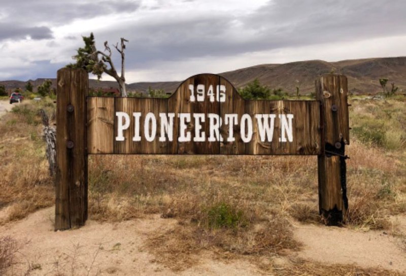
We were soon at the turnoff to the left that went to Pioneertown. Pioneertown is an unincorporated community of the Morongo Basin region of the High Desert in San Bernardino County, California. It is an 1880s-themed town developed as a shooting location for actors working on Western films and TV series with businesses and residences. The Mane Street Historic District is listed on the National Register of Historic Places. The winding, 4-mile drive northwest to Pioneertown from Yucca Valley has been designated a California Scenic Drive and the area is now surrounded by privately and federally protected lands.
Actor Dick Curtis started up the town in 1946 as an 1880s themed live-in Old West living, breathing motion-picture set. The town was designed to provide a place for production companies to enjoy while also using their businesses and homes in movies.
Pioneertown's founders intended the area to be a residential area with Mane street acting as both a movie set and the towns commercial district. Hundreds of Westerns and early television shows were filmed in Pioneertown, including The Cisco Kid and Edgar Buchanan's Judge Roy Bean. Dick Curtis, Roy Rogers and Russell Hayden were some of the original developers and investors. Gene Autry filmed his weekly show in town for five years, using the buildings and businesses as part of the film set.
In 2020, Pioneertown's Mane Street area was recognized as a historic district by the National Register of Historic Places.
As we continued on, we knew when we were getting close to Plam Springs -- as we could see the windmill farms.
We stopped to get gas at Agua Caliente in Palm Desert, California. We arrived back at Palm Springs Thousand Trails campground at 3:45 p.m.
What a spectacular mind-blowing whirlwind of day we had!
Shirley & Mel


The scenery is just beautiful. What a burger!!! It looked delicious. The cost to eat out there is pretty expensive but you get allot. It's amazing that many camp sites no water. Glad everything is going well.
ReplyDelete