The sun continues to shine on us and today the temperature started at 52 degrees and would reach 79 degrees. We left at 7:30 a.m. and headed out on CA Hwy 25 North toward Soledad Canyon Thousand Trails in Acton, California.


.jpg)


.jpg)


_(cropped).jpg)
_(cropped).jpg)
(Shown above is Mission San Buenaventura in 1839.)


.jpg)


.jpg)


Salinas is now 17 miles away, while San Luis Obispo is 143 miles away.

San Luis Obispo is now 77 miles away.


San Luis Obispo is now 36 miles away.

We are now in San Luis Obispo, California, a city and county seat of San Luis Obispo County, in California, with a population of 47,063. San Luis Obispo is roughly halfway between the San Francisco Bay Area in the north and Greater Los Angeles in the south.
San Luis Obispo was founded by the Spanish on September 1, 1772, when Saint Junípero Serra established Mission San Luis Obispo de Tolosa (shown below). The town grew steadily through the Mexican period before a rapid expansion of San Luis Obispo following the American Conquest of California. San Luis Obispo is a popular tourist destination, known for its historic architecture, vineyards, and hospitality, as well as for being home to California Polytechnic State University, San Luis Obispo.
.jpg)
The earliest human inhabitants of the local area were the Chumash people. One of the earliest villages lies south of San Luis Obispo and reflects the landscape of the early Holocene when estuaries came farther inland. The Chumash people used marine resources of the inlets and bays along the Central Coast and inhabited a network of villages, including sites at Los Osos and Morro Creek.
While we were in San Luis Obispo, California we got gas at the Speedy Express and then ate at the Taco Bell before continuing down the road.


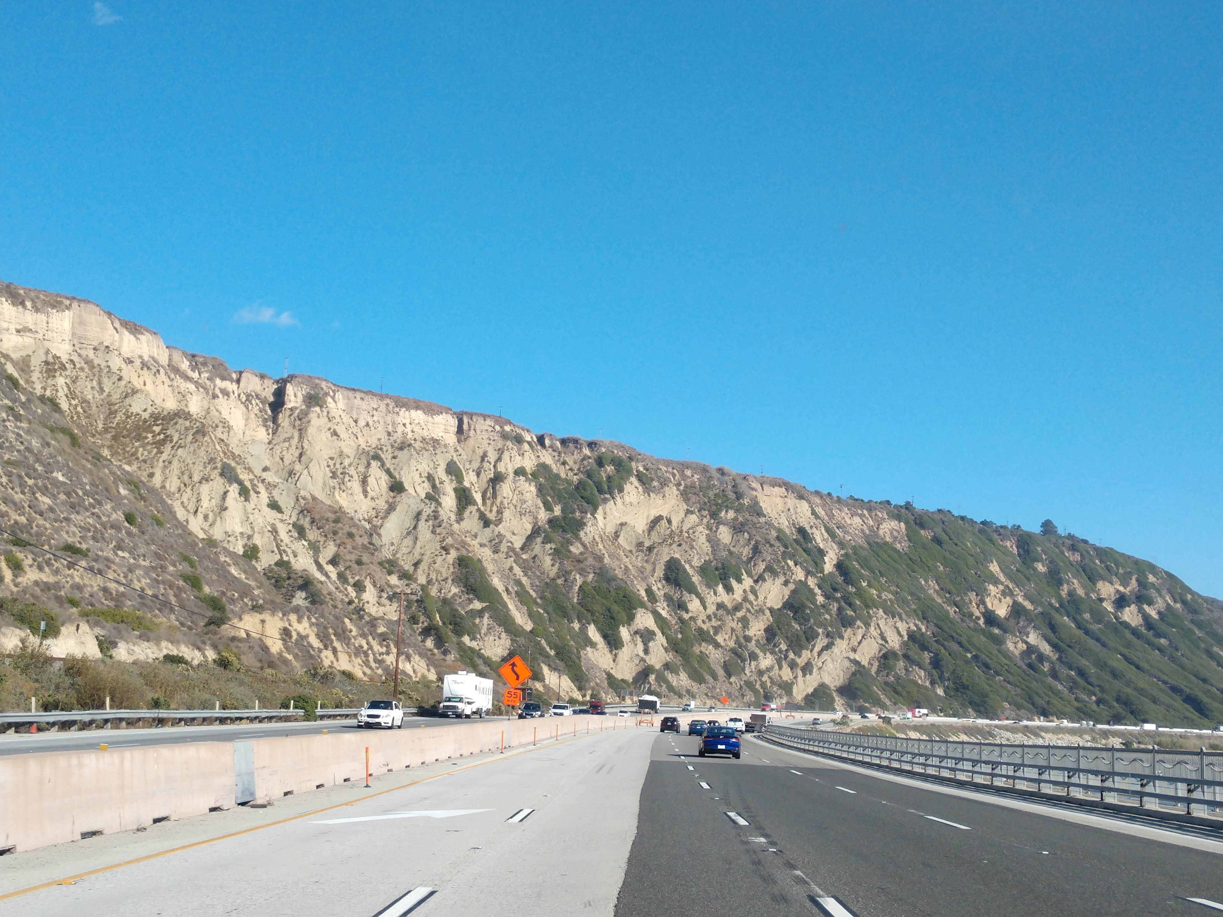
We drove by Pismo Beach and the Pacific Coast Highway. Pismo Beach is a city in the southern portion of San Luis Obispo County, in the Central Coast area of California, with a population of 8,072.

The Chumash people are the historic inhabitants of the region, with indigenous peoples having lived along the California coast for at least 11,000 years. The name Pismo comes from the Chumash language word for tar, which was gathered from tar springs in Price Canyon near Pismo Beach. The tar was a valuable product, which the Chumash used to caulk their seagoing canoes, called tomol, which traveled along the coast and out to the Channel Islands. The first European land exploration of Alta California, the Spanish Portolá expedition, passed through the area, traveling up Price Canyon from Pismo Beach, where they camped on September 4, 1769. Franciscan missionary and expedition member Juan Crespí noted in his diary that they found a Chumash village near the creek.

The first wharf at Pismo was built in 1882, followed by a full-length pier built in 1924 that was financed and constructed by William Woodrow Ward, who allowed full use of it by the public. After it suffered considerable storm damage, the pier was renovated again in 1985.
The legendary Pacific Coast Highway was first started in the 1930s, and remains a marvel of human effort that hugs over 600 miles of California’s rugged and beautiful coastlines. It is one of the most astoundingly scenic roads in the world, meant to be traversed slowly, while gasping at the mountains, towering trees, expansive beaches and endless sky.


It is 14 miles to Santa Maria, and 90 miles to Santa Barbara.

Then we drove by Santa Maria, California, which is a city in the Central Coast of California in northern Santa Barbara County. It is approximately 65 miles northwest of Santa Barbara and 150 miles northwest of downtown Los Angeles. It has a population of 109,707, making it the most populous city in the county. The city is notable for its wine industry and Santa Maria-style barbecue.

Santa Maria was named by noted Californio ranchero Juan Pacífico Ontiveros (shown above). The Santa Maria Valley, stretching from the Santa Lucia Mountains toward the Pacific Ocean, was the homeland of the Chumash people for several thousand years. The Native Americans made their homes on the slopes of the surrounding hills among the oaks, on the banks of the Santa Maria River among the sycamores, and along the coast. They had unique plank-built boats, called Tomol, which they used for ocean fishing.
.jpg)
In 1769, the Portolá Expedition passed through the Santa Maria Valley during the first Spanish land exploration up the coast of Las Californias Province. Gaspar de Portolá y Rovira was a Spanish military officer, best known for leading the Portolá expedition into California and for serving as the first Governor of the Californias. His expedition laid the foundations of important Californian cities like San Diego and Monterey, and bestowed names to geographic features throughout California, many of which are still in use.

Mission San Luis Obispo de Tolosa (shown above) was established just north of the valley on September 1, 1772 by Father Junípero Serra in San Luis Obispo, California. Named after Saint Louis of Anjou, the bishop of Toulouse, the mission is the namesake of San Luis Obispo.

Mission La Purísima Concepción (shown above) was established near present-day Lompoc on December 8, 1787. Rather than rich soil, white settlers were attracted here by the possibility of free land. In 1821, after the Mexican War of Independence, the mission lands in Santa Maria Valley were made available for private ownership under a Mexican land grant called Rancho Punta de Laguna. At the end of the Mexican War in 1848, California was ceded to the United States, and was granted statehood with the Compromise of 1850. In the late 19th century, the area's rich soil attracted farmers and other settlers. By the end of the century, the Santa Maria River Valley had become one of the most productive agricultural areas in the state. Agriculture remains a key component of the economy for the city and the entire region.


Santa Barbara is now 26 miles away, while Ventura is 54 miles away.


We once again got to see beautiful views of the Pacific coastline.


Ventura is now 21 miles away.


We continue to see views of the Pacific Ocean along our drive.


Shown above is another El Camino Real bell marker (but it looks like the bell is missing from this one -- which may be due to political reasons like the historical statues from our history that have been taken down or destroyed). The missions were first established between 1683 and 1834 and were accessed through three different routes. The first bell marker was hung in 1906, to distinguish the route and preserve its history. It was put on a staff shaped as a Franciscan walking stick and placed along El Camino Real.

During 1912, part of the main route began to be paved and was transformed into the road as it exists today. In the coming years, paving continued and hundreds of bells were installed, but many were stolen, vandalized, or simply deteriorated as time went on. As a result in 2005, there was a massive undertaking to restore the bells to their former glory and 555 were installed in all. These new bells are marked with the years 1769 and 1906, to recognize the years the missions began and the year the bells began, respectively.


We are now at Ventura, California, which was officially named San Buenaventura, a city in and the county seat of Ventura County, California. It is a coastal city located northwest of Los Angeles with a population of 110,763. Ventura is a popular tourist destination, owing to its historic landmarks, beaches, and resorts.
_(cropped).jpg)
Ventura has been inhabited by different peoples, including the Chumash Native Americans, for at least 10,000 years. With the arrival of Spanish missionaries in 1782, Mission San Buenaventura (see above) was established by Junípero Serra, giving the city its name. Following the Mexican secularization of the Californian missions, San Buenaventura was granted by Governor Pío Pico to Don José de Arnaz as Rancho Ex-Mission San Buenaventura and a small community arose. Following the American Conquest of California, San Buenaventura eventually incorporated as a city in 1866. The 1920s brought a major oil boom, which along with the post–World War II economic expansion, significantly developed and expanded Ventura.
_(cropped).jpg)
(Shown above is Mission San Buenaventura in 1839.)
Archaeological discoveries in the area suggest that humans have populated the region for at least 10,000–12,000 years. Archaeological research demonstrates that the Chumash people have deep roots in central and southern coastal regions of California, and has revealed artifacts from their culture. They had keen oceanic navigational skills made use of the abundant local resources from sea and land.


We drove by the Ventura Harbor and the Channel Islands National Park. Ventura Harbor is the gateway to five islands: Anacapa, Santa Cruz, Santa Rosa, San Miguel, and Santa Barbara. Channel Islands National Park consists of five of the eight Channel Islands off the Pacific coast of California. Although the islands are close to the shore of the densely populated state, they have been relatively undeveloped. The park covers 249,561 acres, of which 79,019 acres are federal land. The Nature Conservancy owns and manages 76 percent of Santa Cruz Island, the largest of the eight.


We followed CA Hwy 126 East toward Santa Clarita.

Fillmore is 5 miles away, Piru is 12 miles away, and Santa Clarita is now 24 miles away.


We are now in Fillmore, California, a small city in Ventura County, in the Santa Clara River Valley. In an agricultural area with rich, fertile soil, Fillmore has a historic downtown that was established when the Southern Pacific built the railroad through the valley in 1887. The rail line also provided a name for the town: J. A. Fillmore was a general superintendent for the company's Pacific system. Fillmore has a population of 16,419.

In 1769, the Spanish Portola expedition, first Europeans to see inland areas of California, came down the valley from the previous night's encampment near today's Rancho Camulos and camped in the vicinity of Fillmore on August 11. Fray Juan Crespi, a Franciscan missionary travelling with the expedition, had previously named the valley Cañada de Santa Clara. He noted that the party travelled about 9–10 miles and camped near a large native village. Founded in 1887 upon the arrival of the Southern Pacific Rail line, the city voted to incorporate in 1914, after a vigorous campaign by local business owners and the Fillmore Herald.

The McDonald's shown above and below looks like one of the first McDonald's, with Speedee, McDonald's first mascot and also the first company logo before the use of the Golden Arches design from 1962. As the brainchild of brothers Maurice “Mac” and Richard “Dick” McDonald, the Speedee character was developed in 1948 as the mascot for the company's "Speedee Service System".

In order to meet the demands of their soon booming venture, the “Speedee Service System” was conceived with a simple premise — provide a limited menu from which guests can be served efficiently so volume can be increased and prices can be lowered. At the time, the innovative system was one in which "customers walked up to the window to get their own food", as opposed to being served at a table. Additionally, the McDonald's stripped their menu down to burgers, fries, and soft drinks. The point was to make serving the customer as quick as possible.

To advertise their speed, however, McDonald's needed a mascot. So, that was when they created Speedee. Speedee is often described as an early iteration of the McDonald's logo featuring Speedee -- a jaunty, pudgy, winking little chef with a hamburger for a head and a chef's hat, holding a sign reading, "I'm Speedee." The "Speedee" character was replaced by a new logo in 1961 and the Ronald McDonald figure we are all familiar with was created in 1963.

We drove out of the Ventura area and saw more majestic mountains.


Next, we followed I-5 South.

San Fernando is now 15 miles away, while Los Angeles is 36 miles away.


We then drove by the Six Flags Magic Mountain. Six Flags Magic Mountain is a 209-acre amusement park located in Valencia, California, 35 miles northwest of downtown Los Angeles. With 20 roller coasters, Six Flags Magic Mountain holds the world record for most roller coasters in an amusement park. In 2019, the park had an estimated 3.61 million visitors, ranking it fifteenth in attendance in North America.


We then took the exit toward CA Hwy 14 North toward Palmdale, California.


We continued along the highway -- look at all the traffic we have now encountered.


We continued to follow CA Hwy 14 toward Palmdale.


Palmdale is now 28 miles away.

We then see the sign for Soledad Canyon Road and Soledad Canyon. Soledad Canyon is a long narrow canyon/valley located in Los Angeles County, California between the cities of Palmdale and Santa Clarita. It is a part of the Santa Clara River Valley, and extends from the top of Soledad Pass to the open plain of the valley in Santa Clarita. The upstream section of the Santa Clara River runs through it.

(Shown above is an aerial view of the Santa Clara River as it winds through Soledad Canyon just east of Santa Clarita.)
The canyon lies between the Sierra Pelona Mountains towards the northwest and the San Gabriel Mountains to the southeast, starting at the northeastern end of Santa Clarita Valley. Traveling northeast through the canyon, it gradually slopes up until the unincorporated community of Acton, near which the Santa Clara River continues east towards its headwaters among the San Gabriel Mountains. Turning north towards Palmdale, the canyon terminates at Soledad Pass, just a few miles south of Lake Palmdale.


Next, we took the exit onto Crown Valley Road toward Acton, California.

We drove by the Acton Park sign on our way into Acton, California. Acton, California, is an unincorporated census-designated place in Los Angeles County, California, near the Antelope Valley, with a population of 7,596. Acton is a small residential community located between the Sierra Pelona Mountains and the San Gabriel Mountains. It is off the Antelope Valley Freeway (Highway 14) south of Palmdale. Acton is roughly 20 miles northeast of the San Fernando Valley, and 47 miles north of downtown Los Angeles by highway.

The town has a rural western theme which can be seen in its homes, commercial buildings and historical buildings, some of which date back to the late 1800s. The homes in the mountains around Acton have views of the valley below. In the valley are ranch style homes, often with equestrian facilities. While Acton is not a part of the Antelope Valley, it is grouped together with the Valley in the General Plan. Acton has a Metrolink commuter rail station on its border with Palmdale that is themed in an "old western" style and has been seen in various movies and commercials.

Acton was founded in 1887 by gold miners who were working in the Red Rover Mine. It was named after Acton, Massachusetts by one of the miners. Two of the best-known gold mines located in Acton were the Red Rover mine and the Governor mine. Mining of gold, copper, and titanium ore continued into the early 1900s. The town originally had served as a railroad camp from 1873 to 1876 when the Saugus-Mojave section of the Southern Pacific Railroad was under construction.
Acton was once considered for the State capital of California. California Governor Henry T. Gage (1899–1903) owned the Governor Mine, hence the name, and sought to relocate the capital to Acton. This effort ultimately failed and the capital was not moved from Sacramento. In the late 1880s, Acton started to become more of a ranching and farming community. In 1889, Acton's first hotel and its first saloon, the "49er" (formerly Sutter's Mill), was opened and is still in business today.

We turned right onto Soledad Canyon Road and made our way to the Soledad Canyon Thousand Trails.


It was a beautiful canyon drive on the way to the Thousand Trails.


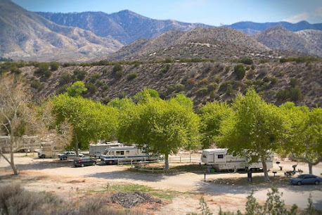
We have finally arrived at the Soledad Canyon Thousand Trails in Acton, California.


With a secluded location in the high desert country along the Santa Clara stream way, Soledad Canyon RV Campground features majestic scenery.


We arrived at 4:30 p.m. at the Soledad Canyon Thousand Trails campground and got set up on site #146 for 7 nights.


.jpg)

For dinner tonight, we had salads topped with tuna.
Wednesday, November 8, 2023
Today started out sunny at 50 degrees, which would reach a high of 68 degrees. It was very windy today as the Santa Ana winds were blowing through the area. Santa Ana Winds occur when air from a region of high pressure over the dry, desert region of the southwestern U.S. flows westward towards low pressure located off the California coast. This creates dry winds that flow east to west through the mountain passages in Southern California. These winds are most common during the cooler months of the year, occurring from September through May.

(As shown above, the air from areas of high pressure inland flows toward sea level in Southern California.)

Santa Ana winds typically feel warm because as the cool desert air moves down the side of the mountain, it is compressed, which causes the temperature of the air to rise. Winds can gust from 45 to 100 mph as they squeeze through passes and canyons depending on the strength of the event. These strong winds can cause major property damage and increase wildfire risk because of the dryness of the winds and the speed at which they can spread a flame across the landscape.


This morning, we had a breakfast of bacon and pancakes. And, then around 12:30 p.m., we decided to go into Acton to the La Cabana restaurant and have a late lunch and early dinner.


La Cabana Restaurant is a quaint, authentic Mexican restaurant located in Acton, Clifornia that serves up generous portions, so you never go away hungry!


We started out with the complimentary chips, salsa and cheesy bean dip (see above).

I had the chicken tortilla soup that came with the meal I ordered (see below).
The chicken tortilla soup is a Mexican-inspired soup that has a tomato and chicken broth base. It is spiced with chili powder, cumin, smoked paprika, oregano, and has a little kick from the jalapeño. It also has hearty ingredients like beans, corn, and of course the shredded chicken topped with crisp tortilla strips.

While Mel had the albondigas Soup which came with the meal he ordered. It is a traditional Mexican Meatball Soup made with beef & rice meatballs, potatoes and zucchini in a rich tomato broth.

Mel and I both ordered the chile relleno and enchilada plate with Spanish rice and ranchero beans (see below).

It was all very delicious and filling!

We got back home around 2:30 p.m. and just enjoyed the rest of our evening.
Thursday, November 9, 2023
Today once again started out windy with the Santa Ana winds continuing to blow. It was however sunny with the temperature ranging from 45 degrees to 64 degrees. We just stayed around the campsite all day.

In the evening, we had a beautiful sunset as you can see from the above and below pictures.

For dinner tonight, we had spaghetti and meat sauce.
Friday, November 10, 2023
Today the wind had died done and it was again sunny starting at 43 degrees reaching 66 degrees by the afternoon.
At around 10:35 a.m., we took off for a drive toward Palmdale, California.

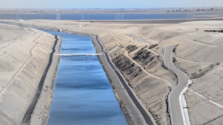
We drove by the California aqueduct numerous times (see below). The California Aqueduct, the principal water-conveyance structure of the California State Water Project, is one of the largest aqueduct systems in the world. The California State Water Project began in 1960, and is designed to transport water to arid southern California from sources in the wetter northern portion of the state. The California Aqueduct conveys water about 705 miles across the state, yielding more than 650 million gallons of water a day. It serves some 27 million people and 750,000 acres of farmland.

From the Sacramento River delta east of San Francisco, the California Aqueduct runs south through the San Joaquin Valley and over the summit of the Tehachapi Mountains, a distance of 273 miles. At the Tehachapi Mountains, water is lifted 1,926 feet at the Edmonston Pumping Plant, the highest single-lift pumping plant in the world. At this point the aqueduct divides into east, coastal, and west branches, the former terminating some 444 miles from the delta. The aqueduct comprises more than 20 pumping stations, five hydroelectric plants, and more than 100 dams and flow-control structures. Channel sizes vary along the aqueduct -- a typical section being a concrete-lined canal 40 feet wide at the base, with 30 feet the average depth of flow.

We soon arrived at Palmdale, California, a city in northern Los Angeles County that lies in the Antelope Valley of Southern California. The San Gabriel Mountains separate Palmdale from the Los Angeles Basin to the south. On August 24, 1962, Palmdale became the first city in Antelope Valley. Forty-seven years later, in November 2009, voters approved making it a charter city. Palmdale had a population of 169,450 in the 2020 census, up from 152,750 at the 2010 census. Palmdale is the 32nd most populous city in California.
.jpg)
(Shown above is explorer Juan Bautista de Anza, who led his expedition through the area in 1774.)
Palmdale was first inhabited by various Native Americans. Populated by different cultures for an estimated 11,000 years, the Antelope Valley was a trade route for Native Americans traveling from Arizona and New Mexico to California's coast. Before the arrival of white Europeans, the Palmdale area was occupied by the Kitanemuk.


While in Palmdale we went to Walmart for groceries and then to Aldis for groceries. After that we stopped at Taco Bell for lunch, and then at the Arco gas station for gas. We arrived back home around 2:30 p.m.
Saturday, November 11, 2023
Today started out nice and sunny at 56 degrees. Mel went for a 4.4 mile, 2 hour walk in the late morning. The Garmin GPS screenshot of his walk is shown below.

I went for a walk down to the clubhouse to check on available books to pick up to read, but since I was down there before they opened at 10:00 a.m., I had to walk down again after lunch. Both my walks were 3/4 of a mile in length, in just over 25 minutes. The Garmin GPS screenshot of my morning walk is shown below.


View of the campground below from the upper level where we were camped.

I took a few pictures on my walk around the campground in the morning.

Shown above is yellow rabbitbrush, one of the most widely distributed shrubs on rangelands throughout western North America. It occurs from British Columbia south to southeastern California and east to North Dakota, Arizona, New Mexico and Texas. Rabbitbrush grows wild in semi-desert areas up to an altitude of 8,000 feet and does well even in disturbed soils, such as the burnt soils of areas that have suffered fires. Larger varieties of this shrub grow to approximately five feet high and wide.

I walked across the bridge where the Santa Clara River has appeared to have dried up.

The Metrolink commuter train runs along the side of the Thousand Trails park. It is a commuter rail system in Southern California.
I worked on my blog in the afternoon. For dinner, we had chicken thighs, and I had a twice-baked potato while Mel had a twice-baked sweet potato.
Sunday, November 12 and Monday, November 13 were both wonderfully sunny days (with temperatures ranging from 48 degrees to 68 degrees). We just hung around the campsite enjoying the mountainous scenery.
We enjoyed our time in Soledad Canyon -- from the Santa Ana winds to the beauty of all that nature could provide. Nature does not hurry, yet everything is accomplished and it is ours to enjoy!
Shirley & Mel


No comments:
Post a Comment