Tuesday, October 24, 2023
Today started out cloudy at 56 degrees, but soon turned sunny and reached a temperature of 75 degrees in the afternoon. Today was a travel day as we moved from the Morgan Hill Thousand Trails in Morgan Hill, California to the San Benito Thousand Trails in Paicines, California (46 miles away).


We drove by the East entrance into Pinnacles National Park (that is where we will be going another day).

We are now 12 miles from Hollister, and 46 miles from Pinnacles.

Tres Pinos is now 5 miles away and Pinnacles National Park is 32 miles away.

We turned off of CA Hwy 25 to the right onto the gravel road -- Cienega Road (that is an old farm road that parallels the highway).
.jpg)
We turned left at the Paicines Ranch sign and continued along Cienega Road.
Paicines, California is an unincorporated community in San Benito County, California. The community is at the intersection of Panoche Road and SR 25. Paicines originated in a community that arose on Rancho Ciénega de los Paicines, a rancho grant issued by Governor Juan Bautista Alvarado in 1842 to Ángel María Castro and José Antonio Rodríguez. The town of Paicines was originally located 5 miles north of the town of Tres Pinos. The railroad was tasked to build a line to Tres Pinos. By 1873 they made it to Paicines but did not wish to continue building more line. So in 1874 the names of the two towns were switched so the railroad could say they had fulfilled their commitment to build a line all the way to Tres Pinos.

We now see the Thousand Trails sign and follow Cienega Road around to the right.

The road winds around the mountains and soon we cross over a bridge and turn right into the San Benito Thousand Trails, located in a pristine location just 14 miles south of Hollister, California.

From that entry point, we still have to wind around the road until we are at the official entrance to San Benito Thousand Trails.


The campground is decorated for Halloween as you can see from the mock gravestones in a makeshift graveyard to the right in the above picture. There are black ghouls and a cauldron by the gate as we enter.


Following the signs, we see the check-in is ahead to the right.

As part of their Halloween hype, we pass by a couple of skeletons sitting our by a fire ring.


And then we get all set up on site #369 for 14 nights.

We note that the tree that is along the right side of our campsite is a pecan tree (see pictures below).


After lunch, I decided to go for a bike ride around the campground. It ended up being just over a 4 mile and 38 minute bike ride. While I was riding around the campground, I took some pictures of the Halloween decorations.

Above is a creepy character, while below is a San Benito "It Little House" with spiders and little trolls.


Along my bike ride, I also ran into the scary Freddy Krueger figure, who was a fictional character and the primary antagonist in the "A Nightmare on Elm Street" film series. He was created by Wes Craven and made his debut in 1984. In the film "A Nightmare on Elm Street," Freddy was introduced as a serial child killer from the fictitious town of Springwood, Ohio, who killed his victims with a bladed leather glove from his own imagination that he crafted in a boiler room where he used to take his 20 victims. He was commonly identified by his burned, disfigured face, dirty red-and-green-striped sweater and brown fedora, and trademark metal-clawed, brown leather, right hand glove (see below).

Freddy Krueger was captured, but set free on a technicality when it was discovered that the search warrant was not signed in the right place. He was hunted down by a mob made up of the town's vengeful parents and cornered in the boiler room. The mob doused the building with gasoline and set it on fire by throwing Molotov cocktails, burning him alive. While his body died, his spirit lived on within the dreams of a group of teenagers and pre-adolescents living on Elm Street, whom he preyed on by entering their dreams and killing them, fueled by the town's memories and fear of him and empowered by a trio of 'dream demons' to be their willing instrument of evil.

I spied another Halloween decoration of a witch that is splatted against a tree.

Shown above and below are trolls hidden in trees around the campground, that I assume are there year-round.

Shown below is the Garmin GPS screenshot of my 4 mile, 38 minute bike ride that I took today.

The rest of the afternoon, we just stayed at the campsite. For dinner, we had steaks and broccoli.
Wednesday, October 25, 2023
Just another sunny day with a temperature of 56 degrees that would reach 68 degrees. We just stayed around the campsite and I worked on my blog. For dinner, we had pork chops and angel hair pasta.
Thursday, October 26, 2023
Today was a beautiful sunny day with a temperature of 53 degrees. We decided to take a road trip and go to Pinnacles National Park. We left around 9:30 a.m.

The trip to Pinnacles National park was about 18 miles along CA Hwy 25 East.

Soon we were at Pinnacles National Park. Pinnacles National Park is a national park protecting a mountainous area located east of the Salinas Valley in Central California, about five miles east of Soledad and 80 miles southeast of San Jose. The park's namesakes are the eroded leftovers of the western half of an extinct volcano that has moved 200 miles from its original location on the San Andreas Fault, embedded in a portion of the California Pacific Coast Ranges.

The national park is divided by the rock formations into East and West Divisions, connected only by foot trails. The east side has shade and water, while the west has high walls. The rock formations provide for spectacular pinnacles that attract rock climbers. The park features unusual talus caves that house at least 13 species of bats. Pinnacles is most often visited in spring or fall because of the intense heat that occurs during the summer.

Pinnacles was originally established as a national monument in 1908 by President Theodore Roosevelt, and was redesignated as a national park in 2013 by President Barack Obama. Pinnacles National Park is visited by approximately 222,000 people annually and is the seventh smallest of the National Parks at only 26,606 acres. First and foremost, there are two sides to Pinnacles National Park and the two sides are not connected by roads.
Native Americans in the Pinnacles region comprised the Chalon and Mutsun groups of the Ohlone people, who left stone artifacts in the park. These native people declined with the arrival of the Spanish in the 18th century, who brought novel diseases and changes to the natives' way of life. The establishment of a Spanish mission at Soledad hastened the area's native depopulation through disease and dispersion.

Archaeological surveys have found 13 sites inhabited by Native Americans, 12 of which antedate the establishment of the missions. One site is believed to be about 2000 years old. The last Chalon had died or departed from the area by 1810. From 1810 to 1865, when the first Anglo-American settlers arrived, the Pinnacles region was a wilderness without human use or habitation.
By the 1880s the Pinnacles, then known as the Palisades, were visited by picnickers from the surrounding communities who would explore the caves and camp. The first account of the Pinnacles region appeared in print in 1881, describing the Balconies area. Between 1889 and 1891, newspaper articles shifted from describing excursions to the "Palisades" to calling them the "Pinnacles". Interest in the area rose to the point that the Hollister Free Lance sent a reporter to the Pinnacles, followed two months later by a party of local officials.

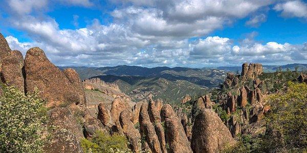
We entered on the East side of the Pinnacles National Park. Pinnacles National Park is so named for the high peaks of volcanic rock that were thrust up from the earth’s crust and migrated through tectonic forces to this part of modern-day California. These High Peaks are beautiful and unique among California’s national parks – and indeed all of California’s mountains and rock formations.
As we planned to head to the Bear Gulch area, we continued straight ahead.


We have just entered into Pinnacles National Park.

Because I have a senior lifetime pass to national parks, we didn't have to pay anything at the visitor center -- otherwise we would have had to pay $30.

We stopped at the Pinnacles National Park Visitor Center for maps and the passport stamps. It was there we were told about the hike to the Bear Gulch Caves, that we decided we wanted to do.

So we then got back on our way toward Bear Gulch.


Here we turned left to continue toward Bear Gulch.

The views along the way were spectacular.


The ranger at the visitor center had told us to park in the Bear Gulch parking area.

Shown above is the blow-up of the park map showing where the visitor center we stopped at was (on the right in green), and where we are now (in the middle in red).


Shown above was the map that showed where we parked at -- Bear Gulch and then where we walked along to the Moses Spring Parking Area. From that parking area, we then followed the Moses Spring Trail to where it split from the High Peaks Trail. We then followed the Bear Gulch Cave Trail (see below the red You Are Here).
The Moses Spring Trail was an easy to moderate hike from the Bear Gulch Day Use Area. It connected to Bear Gulch Cave after a little more than 0.5 miles. When we had hiked the whole length of the cave, our whole hike today would be roughly 2.4 miles out and back. From the Bear Gulch Cave, Mel hiked on to the Bear Gulch Reservoir. Because there was an area where I would have to crawl on my knees to get out of the Bear Gulch Cave, I didn't continue on to the Bear Gulch Reservior with Mel.


We followed the Moses Spring Trail to the Bear Gulch Cave Trail. The Moses Spring Trail was a beautiful walk along a dirt path in the forest. It was beautiful, and there were bright green moss-covered rocks everywhere.

Off we go continuing along the trail, and as you can see from the above picture, the trail ascends upward, as we continual to hike amongst rock formations on the Moses Spring Trail.


Because I stopped often to take pictures, Mel had to stop frequently and wait for me to catch up. Note how beautiful the scenery was along the trail.

With just a few steps into the trail, we came across the rocky mountains with pinnacle-shaped rocks. The tan mountains were a splendid contrast against the green forest and blue sky backdrop!


A little further into the Moses Spring Trail, we reached a fork with the left path going to the Bear Gulch Cave Trail and the right path leading to the Rim Trail and High Peaks Trail. We stayed on the trail to the left, which eventually got us to the Bear Gulch Cave Trail. This portion of the hike was really cool because it hugged rock walls and boulders, while passing through a short tunnel that led us through a rock hallway.


We continued along the trail.


In some areas, we had to scramble over boulders along the trail.

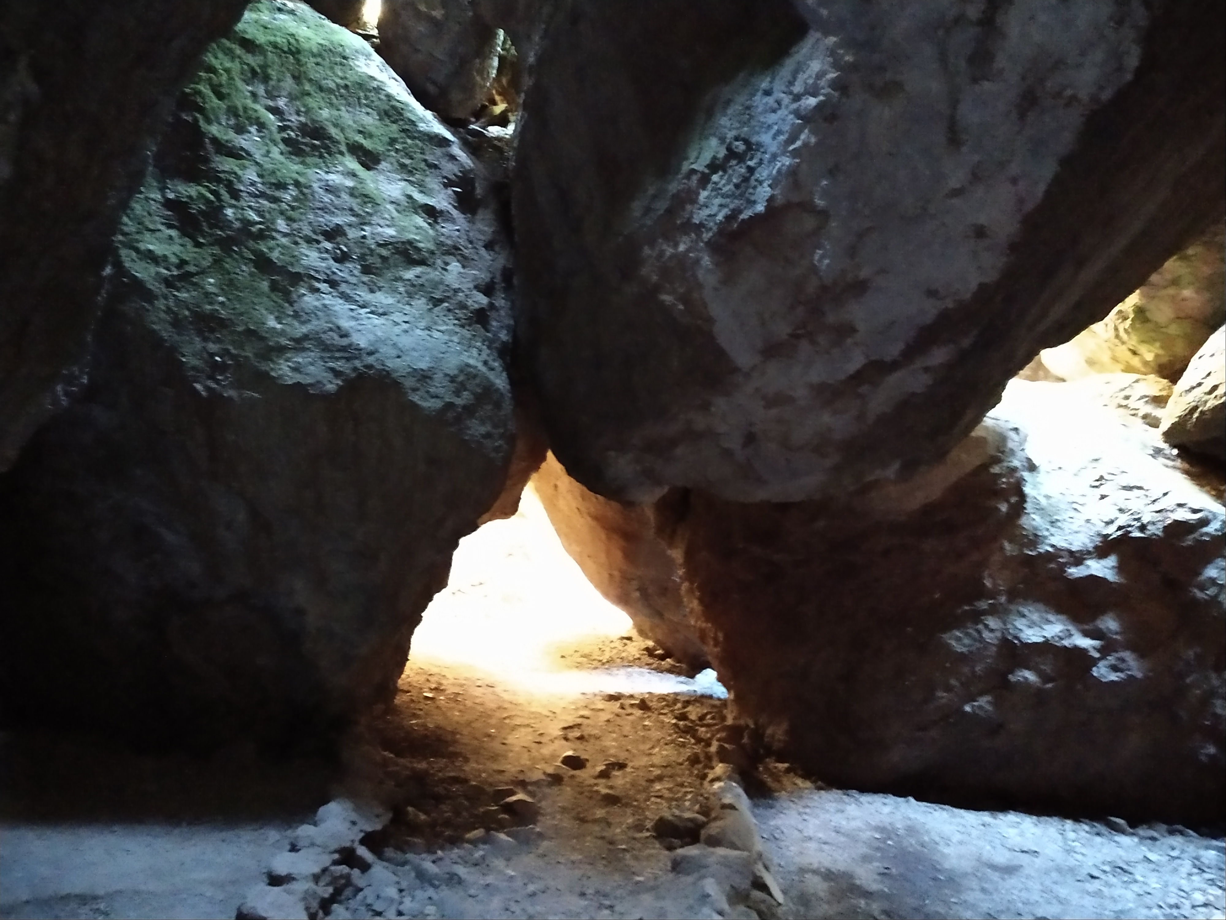
Above and below was a small cave that we passed through here -- it was just a sneak peek of what was to come ahead!


Sometimes we even had to weave in and out of trees and tree stumps.

Above, Mel entered into a short tunnel along the trail.

Mel was now through the short tunnel.

Since I was lucky enough to have a lady following me on the trail, she offered to take my picture as I began to enter the tunnel (see below).


Above was my view as I came out of the short tunnel along the trail.

We continued on and Mel was again getting ahead of me as you can see in the picture below.


Another couple of awesome views from the trail.

The Talus Caves in Pinnacles National Park are one of the main attractions – and part of the hiking experience. Talus caves are openings formed between boulders piled up on mountain slopes. Most of them are very small both in length and in cross section. Some boulder piles, however, do have explorable interconnected “passages” of considerable length. The talus caves at Pinnacles National Park are amazing! Bear Gulch Cave is also home to a colony of Townsend’s Big-Eared Bats.

Mel stands ready to enter into the talus cave -- Bear Gulch Cave.


And some areas are tight squeezes.

The entrance to Bear Gulch Cave was a tiny space between the two large boulders.
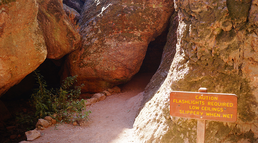
The above sign cautioned us that flashlights were required. We hadn't brought a flashlight, but had our cell phones. It also warned of low ceilings and slippery areas.

The opening of the Bear Gulch Cave was quite narrow -- we had to squeeze our way in sideways! It then widened into a partly covered cave with a rocky floor.

The rocky floor had several areas where we had to carefully step on the bigger rocks to keep our shoes from getting soaking wet.


And at this area, there was a wooden plank across the water.

We were surprised that inside the Bear Gulch Cave that was created by massive stacked boulders, there was a staircase!

There were many, many stairs in the caves that had been carved in the stone, and it seemed like we continually climbed and climbed upward. There were also places where we had to duck.


Bear Gulch Cave at the Pinnacles National Park was formed by rockfall events that infilled an existing canyon most likely during the last ice age. The stairs originally constructed in the 1930s by the Civilian Conservation Corps, provided ease of access and led visitors into one of the best examples of a talus cave in the National Park Service (shown above).

There were several sets of stone stairs in the lower cave with hand railings. At the top of the stairs, we reached a fork in the path -- with the continuing trail to Upper Bear Gulch Cave heading to the right (but it was closed as it is most of the year), and the exit of the cave being across a metal grate through a narrow slot to the left (see below).

I tried to squeeze through the very low ceiling area by standing up, but no such luck. I determined that I was not going to be able to crawl out of the cave on my knees. So I told Mel to go ahead without me -- I would stay here and wait. So at this point, Mel followed the trail out of the cave, first by crawling on all fours along the metal grate as he squeezed his way out of the cave.
I sat down on the metal grate and waited in the dark all by myself for Mel's return. Since I heard a few noises, I began to sing some songs and call out every once in awhile to pass the time.
Also, while I was waiting for Mel's return, I used my phone light to look around a little bit. Since we had been told that there were bats in the cave, and I had heard a little fluttering sound, I started looking around with my cell phone light. And then I did find some bats hanging from the ceiling area in the upper cave area that was closed and took a picture (see below).

Bear Gulch Cave was currently home to a colony of several hundred Townsend's big-eared bats. It was the largest colony known between San Francisco and the Mexican border, that roost on walls and ceilings of large rooms. The bats appeared to only use the upper portion of the cave during most of the year -- so that is why that area had been closed.
* * * * * * * * * *
From this point on, I am sharing the pictures Mel took on his exit out of the Bear Gulch Cave to the Bear Gulch Reservior, while I sat and waited in the dark inside the cave.

Once Mel emerged from the cave, he had to climb up some more steps to get up to Bear Gulch Reservoir. This part was one of the most epic views of the narrow canyon. As you see, there was a huge boulder lodged mid-air between the canyon walls that he had to walk below.
.jpg)
And then Mel had to ascend a steep staircase to the gorgeous Bear Gulch Reservoir! There were rocks around the reservoir and the rock formations spread out into the distance beyond the reservoir. Mel said it they looked really cool.
.jpg)
As soon as he reached the top of the stairs, bam -- he could then see the Bear Gulch Reservoir appear out of nowhere! It was just spectacular!

Bear Gulch Reservoir has been a Pinnacles National Park highlight for nearly a century. The dam, which created the Bear Gulch Reservoir, was completed in 1935 by the Civilian Conservation Corps both to prevent flooding downstream, as well as for its aesthetic value. The reservoir provides an important habitat for red legged frogs. The water reflections at the reservior were almost glass-like and amazing.

And the views from the reservior were magnificent!
.jpg)
Mel walked on for a little distance from the reservoir.
.jpg)
The above sign told where the Rim Trail continued.
.jpg)

The Bear Gulch reservoir was extremely scenic, with the Monolith mountain at one end and the calm waters surrounding it.
.jpg)
Mel stopped to take a selfie in front of the Monolith mountain.
.jpg)
Then from Bear Gulch Reservoir, he turned back around and came back to the cave where I was waiting for his return. From the Bear Gulch Reservoir, Mel went back the same way by following the Bear Gulch Cave Trail back inside the cave.
.jpg)
Mel descended back down the stairs.
.jpg)
.jpg)
And back inside the cave to where I was waiting. We then made our way out of the cave and down all the stairs we had climbed earlier in the day, using our cell phones to light the way.
.jpg)
I crossed the rocky wet area and we could finally see the light through the tunnel -- and we were back outside!

Mel is following the trail back.

Once again, back through the short tunnel we go.


Continuing down the trail we go.


We continued to enjoy the beautiful sights on the trail as we walked along.


Almost back to the truck, we crossed a little bridge (see below).


We are now heading back to Hollister, California.


We are now 32 miles from Hollister.

The town of Hollister and the surrounding agricultural valleys (Santa Ana Valley and San Juan Valley) are flat, but they’re surrounded by small, rolling hills rich with meandering roads. The Diablo Mountain Range runs along the eastern side of San Benito County. And, in Hollister we could easily see Santa Ana Mountain.


We see lots of vineyards in this area.

We are now in Hollister, California, a city and the county seat of San Benito County, located in the Central Coast region of California. It has a population of 41,678, and is one of the largest cities in the Monterey Bay Area. The city is an agricultural town known primarily for its local Blenheim apricots, olive oil, vineyards, pomegranates, and chocolate.

The area of modern-day Hollister was historically inhabited by the Mutsun band of the Ohlone Indians. With the construction of Mission San Juan Bautista in 1797, the Ohlone went into the California mission system. The town of Hollister was founded on November 19, 1868, by William Welles Hollister on the grounds of the former Mexican land-grant Rancho San Justo. At the time, Hollister was located within Monterey County, until San Benito County was formed by the California Legislature in 1874 from portions of Monterey, Merced, and Santa Cruz counties.
AND OH NO . . . AT AROUND 1:15 P.M. AS WE DROVE INTO HOLLISTER -- THE TRUCK IS STARTING TO RUN REALLY ROUGH! THE CHECK ENGINE LIGHT CAME ON!
So we inched it into the parking lot in front of the O'Reilly Auto Parts store, but it wouldn't start again. Mel went inside to see if they could put the computer on it, so we could figure out what was wrong. They said that they couldn't tell us what what was wrong, but there was a SpeeDee-Midas auto shop just down a ways in this shopping area.
After waiting for a few minutes, Mel was able to get the truck started again -- but as it choked and sputtered he drove it as quickly as possible through the parking lot until he was in front of the SpeeDee-Midas auto shop.

So then at about 1:45 p.m., Mel was able to get the truck checked in. They said it would be an hour before they could get it pulled into one of the stalls, and then it would take the computer a couple of hours to do the analysis.

We then decided to walk over to the Taco Bell and get something to eat. As you can see by the map shown above, it wasn't too far away. We sat over there for awhile waiting to see if they would call with the results of the computer analysis.
When it got to be around 4:00 p.m. and they hadn't called yet, we walked back over to the SpeeDee-Midas auto shop. Shortly, after that Mel walked out to see what they had found out and it wasn't good news.
WE WERE GOING TO NEED A WHOLE NEW ENGINE, AND THAT WAS GOING TO COST $11,704! BUT WHAT WERE WE TO DO, BUT BITE THE BULLET AND TELL THEM TO GO AHEAD AND ORDER IT!

So that is what we did -- and we now are on a waiting game until the new engine comes in and they can get it installed. Since we didn't have a vehicle to get back to the campground, the owner of the shop took us home. We got back to our campsite around 6:45 p.m.

Above and below is the Garmin GPS screenshot of our walk today at Pinnacles National Park to the Bear Gulch Cave. An truly awesome walk for sure!

One thing we learned today is to persevere -- in other words continue in a course of action even in the face of difficulty. We learned to always push ourselves to go even if it was just another 100 feet.
Today, it was about always going a little bit further on the next trail. Even though we're tired and our feet ache, we should want to see what's around the next turn, and so we would push ourselves -- just another 100 feet, and see what's there. Then we would think we're ready to turn back, but wonder what's just up ahead. So we'd push ourselves to go another 100 feet, and see what's there. Then we'd decide to go just another 100 feet. Hmmmmmm . . . may you alway push on!
Shirley & Mel


Sorry to hear about your truck. You went allot of miles on it for sure. Glad your back at camp ground. Hopefully it won't be weeks or months before you get it back. Will you rent a car temporarily to get to grocery store etc. Hope all works out. Keep us all posted. Hang in there.
ReplyDelete