Sunday, September 10, 2023
Another beautiful sunny day with the temperature starting at 57 degrees, and reaching a high of 80 degrees.
We left today at 9:00 a.m. and headed toward Mt. Baker. The Mt. Baker Highway (WA Hwy 242) follows the North Fork Nooksack River Valley in Eastern Whatcom County and provides access to some of the most scenic areas in all the United States. The highway winds through farmlands, rolling wooded hills, and small communities including Nugents Corner, Deming, Kendall, Maple Falls and Glacier.
We headed out toward Ferndale, Washington.
(Mt. Baker Highway from Milepost 25 to 56, with trails and campgrounds.)
We turned onto Hwy 542 East toward Mt. Baker right where the Cathedral of Trees at Kendall Chapel is located.
Our first stop was at the Mt. Baker Foothills Chamber of Commerce & Visitor Center in Maple Falls, Washington.
Inside the Mt. Baker Foothills Chamber of Commerce & Visitor Center, I found the neat poster on how to build a community. The verbage on it follows:
Turn off your TV; Leave your house; Know your neighbors; Look up when you are walking; Greet people; Sit on your stoop; Plant Flowers; Use your library; Play together; Buy from local merchants; Share what you have; Help a lost dog; Take children to the park; Garden Together; Support Neighborhood Schools; Fix it even if you didn't break it; Have Pot Lucks; Honor Elders; Pick Up Litter; Read Stories Aloud; Dance in the Street; Talk to the Mail Carrier; Listen to the Birds; Put up a Swing; Help Carry Something Heavy; Barter For Your Goods; Start A Tradition; Ask A Question; Hire Young People for Odd Jobs; Organize a Block Party; Bake Extra and Share; Ask For Help When You Need It;
Open Your Shades; Sing Together; Share Your Skills; Take Back the Night; Turn Up The Music; Turn Down The Music; Listen Before You react To Anger; Mediate A Conflict; Seek To Understand; Learn From New and Uncomfortable Angles; Know That No One is Silent Though Many Are Not Heard; and Work To Change This.


The sign above told us about Mt. Baker. The gleaming crest of Mt. Baker, impressive northern buttress of the Cascade Range, rises skyward to the lofty elevation of 10,750 feet its Indian name "KULSHAN" means steep. Lieutenant Joseph Baker, Vancouver's Valiant Officer, sighted the snowy eminence from far out toward the sea on April 30, 1792 and the captain of the expedition named it in his honor.
We then crossed the bridge over the North Fork Nooksack River. The Nooksack River really puts the 'great' in the Great Northwest. Its spectacular North Fork is the northernmost river in Washington, running wild with icy glacial snowmelt from the snowfields of 10,778-foot Mount Baker and 9,127-foot Mount Shuksan in North Cascades National Park, before being joined by the Middle and South forks as it weaves through forests and farmlands on its way to the Salish Sea in Puget Sound north of Bellingham.
With volcanic Mt. Baker and the Twin Sisters Range of the jagged North Cascades dominating the surrounding landscape, the upper river was shaped as much by fire as ice through the millennia, creating a one-of-a-kind watershed treasured for its vast array of scenery and recreation. Whether it’s whitewater paddling beneath (or skiing atop) towering snowcapped summits; fishing in ancient forests for five species of native salmon, steelhead, resident rainbows, and cutthroat trout; hiking past waterfalls on the nearby network of trails; or scoping out abundant bald eagles, black bears, mountain goats, elk, spotted owls and even the rare bull trout, the Nooksack does not disappoint.
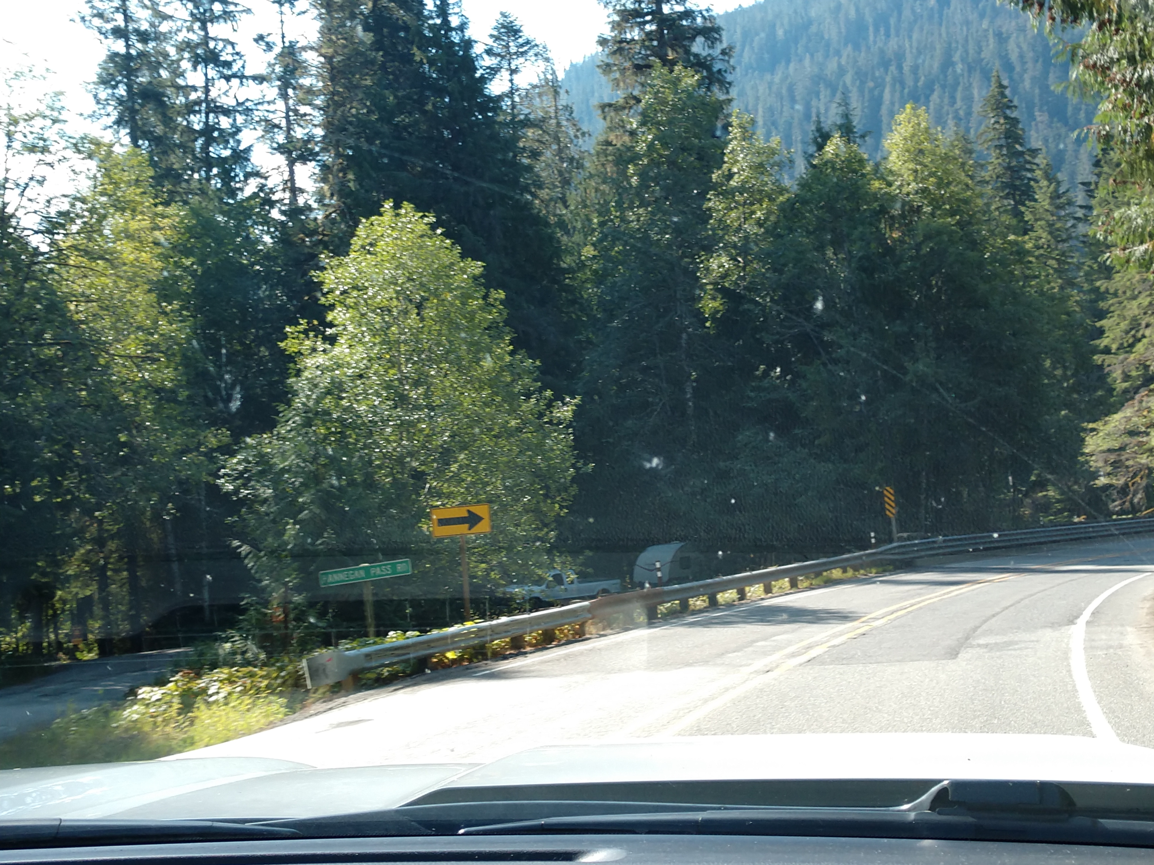
We drove by Hannigan Pass Road (see above) and the Silver Fir Campground (see below).
We then drove by the Mt. Baker Ski Area. The Mt. Baker Ski Area is located in the Mt. Baker-Snoqualmie National Forest and is operated under a permit granted by United States Forest Service.
We then drove past the Heather Meadows Base Area.
The mountains and scenery were simply gorgeous all the way to Artist Point.
We drove past the Lake Ann trailhead.
We were now to the Mt. Baker National Forest Artist Point. Artist Point is at the very end of the Mt. Baker Highway and features boasts 360-degree stunning views of Mount Baker and Mount Shuksan, as well as access to a variety of trails.
With a name like Artist Point, it comes as no surprise that the hikes and roads in this area are truly other-worldly. Everywhere you turn, there’s a picturesque landscape that feels like it came straight out of a painting.
The above storyboard told us about Artist Ridge Trail. Life on Artist Ridge balances precariously at the harsh edge between lush green forests and barren rocks and snow. As you head out on the trail, take some time to enjoy this magnificent setting. With your eyes, trace the line where the mountains greet the sky. Follow the knife-edged ridges down into the hollow valleys. Notice the lace of vegetation veiling coarse lava rock. Watch as the cloud shadows sweep across this grand design.
(View of Mount Shuksan from Artist Point.)
Mount Shuksan holds it own reaching 9,131 feet with two towering peaks (Nooksack Tower and Hourglass), four waterfalls and massive glaciers with enormous faults and flexures that can be seen from the valley below. Mt. Shuksan is over 120 million years old.
The above storyboard told us about the Rugged and Rich Landscape. Looking down into the deep Swift Creek drainage, you will see Baker Lake and the Cascade Mountain Range beyond. Years ago surveyors traversed through this rugged landscape, searching for a way to connect a travel-way through to the Skagit River to the southeast. However, the steep-sided valley presented too much of a challenge, and the land remained unspoiled by roads.


The storyboard above told us about a Fiery Mountain Encased in Ice. In the distance, Mt. Baker stands deceptively still, while inside the ice-encrusted face, a fire burns. During a volcanic eruption, an explosive mass could blast through the surface, vaporizing the mountain's glacial ice and sending hot mud and lava into the valleys below. Ash would billow into the sky before falling far and wide. Mt. Baker's most recent lava flows are less than 9,000 years old. Native Americans and early settlers witnessed ash eruptions in the 1800s. In 1975, volcanic steam melted ice fields, forming a lake in Sherman Crater. Occasionally, steam plumes rise from the crater, reminding us that Mt. Baker is an active Cascade volcano like Mt. Saint Helens to the south.
Our first look at the majestic Mt. Baker (shown above and below).
The storyboard above told us about Venturing Into Wilderness. To the west, the hiker-only Chain Lakes Trail allows access into the surrounding Mt. Baker Wilderness. The Wilderness designation protects natural processes, preserving habitat for wildlife and providing us with all the ingredients for clean air and water. For people, the wilderness offers a more primitive recreational experience. Summer months offer a window of time to hike into this pristine landscape and enjoy a night or two of backcountry camping under the stars. During the long, snow-covered month when road access is closed, an exhiliarating way to trek up into this elevation is on cross country skis or snowshoes. You must be prepared when traveling in these higher elevations, as mountain weather can change rapidly and avalanche danger does exist.
Shown above is Shirley and Mel in front of Mt. Baker.
The Artist Ridge hike boasts a huge payout for relatively little effort. This 1.2 mile lollipop hike is an extremely popular summer photo destination because everyone loves the views of Mount Shuksan, Mount Baker, and beyond.
Mt. Baker, rising to an amazing 10,781 feet is a stunner. It's the third highest peak in Washington state and the second most thermally active crater next to Mt. St. Helens.
At the storyboard above we were at an elevation of 5,100 feet.
Shown above is one last look at Mount Shuksan located in the North Cascades National Park. Shuksan rises in Whatcom County, Washington immediately to the east of Mount Baker, and 11.6 miles south of the Canada–US border. The mountain's name Shuksan is derived from the Lummi word said to mean "high peak". The highest point on the mountain is a three-sided peak known as Summit Pyramid. The traditional name of Mount Shuksan in the Nooksack language is Shéqsan ("high foot") or Ch’ésqen ("golden eagle"). Both the Nooksack and Lummi are indigenous tribes who have occupied the watersheds of the Nooksack Rivers and Lummi River, respectively. They are both federally recognized tribes in the United States.
The first ascent of Mount Shuksan is usually attributed to Asahel Curtis and W. Montelius Price on September 7, 1906. However, in a 1907 letter to the editor of the Mazamas club journal, C. E. Rusk attributed the first ascent to Joseph Morowits in 1897. He said that he himself would have attempted it in 1903 if he had not been sure that it had already been climbed.
We then drove back down to Heather Meadows Visitor Center.
The Civilian Conservation Corps built the Heather Meadows Visitor Center in 1940 for a ski warming hut. Workers used rock and heavy timber to meticulously restore the building’s architectural lines to blend into the surrounding environment. The center sits on a rock ledge at the edge of the Austin Pass Picnic Area and overlooks Bagley Lakes in the Heather Meadows area located along the upper reaches of the Mt. Baker Scenic Byway, State Route 542.
Shown above and below are fantastic views from the Heather Meadows Visitor Center.
Above and below are signs inside the Heather Meadows Visitor Center.
The storyboard above told us about the Bagley Lake Trails around Heather Meadows.
Shown above is Bagley Lake.
Our next stop was at Picture Lake. We parked the truck and walked all the way around Picture Lake.
The trail around Picture Lake is 0.4-mile loop trail.
Picture Lake is the centerpiece of a strikingly beautiful landscape in the Heather Meadows area. The classic alpine vista of Mt. Shuksan mirrored in Picture Lake is one of the most photographed mountain scenes in North America. A backdrop of mountains, wildflowers and colorful plant foliage make this a beautiful hike.


The above storyboard told us about Glacial Sculptors. From this prime photo point, you can see why Mt. Shuksan's striking beauty, reflected in Picture Lake, lures photographers from around the world. Powerful fingers of ice are carving Mt. Shuksan's ancient rocks into a massive sculpture. The present 300-foot thick glaciers are small remnants of massive ice sheets that periodically covered much of North America over the last two million years. During ice advances, the glaciers covering Mt. Shuksan spread and thickened. The ice enveloped the bulk of the mountain and flowed down into the mile-deep sea of ice that covered the lowlands. During interglacials, like the present 10,000 year old warm spell, the glaciers melted back, shaping the peak into the dramatic figure we see today.
Shirley and Mel in front of Picture Lake and Mt. Shuksan. I took a lot of pictures here because it was so beautiful!
And then we hit the road going back on Mt. Baker Highway.
We passed Razor Hone Creek. Razor Hone Creek is a creek in Mt. Baker National Forest, Cascade Range in Washington.
We met a couple of bicylists on the highway.
Soon we were passing the Excelsior Trail.
We were curious about the sign for Nooksack Falls on our drive up to Mt. Baker, so on the way back we took the 15 minute detour of the main highway and went to check it out. The short dirt road was in pretty good shape.
Located just half a mile off of Mount Baker Highway, Nooksack Falls is a must-see for waterfall lovers. These glacial falls plummet 88 feet in two segments down the North Fork of the Nooksack River. Though they are best viewed during winter and spring, Nooksack Falls are accessible year-round.
To reach the viewing area, simply walk across the street from the big parking lot and follow a short, signed path. Check out the interpretive sign near the parking area for some historical information. Black and white photographs depict Nooksack Falls and its hydroelectric power plant, built in 1906. The sign describes a colorful and somewhat amusing history of the plant's ownership.
Nooksack Falls is not only one of the most scenic waterfalls in the northwest, but is also easy to access. A sign at the trailhead near the parking lot details the history of the falls as a source of hydroelectric power and cautions visitors that at least 11 people have died trying to get better views over the years.
Next, we followed the sign for the trail to Nooksack Falls. It's a 200-foot walk down a rutted and root-filled dirt trail that leads to a clifftop viewing area directly across from the falls proper. A chain link fence protects visitors from falling into the chasm between them and the falls. Another sign warns: “Extreme Danger, Do Not Proceed, Slippery Rocks, No Trespassing.”
Nooksack Falls is named after the Native American tribe (Nooksack) that still calls the area home—the Nooksack reservation is based 25 miles to the west in Deming, Washington. The name Nooksack either means “mountain men” (as distinguished from Salish tribes inhabiting the coast) or is a reference to the native word for bracken ferns (“noot-sa-ack”) that historically served as a staple food item for the tribe.
Can you see the face in the Nooksack Falls in the above picture on the left side in the rocks?


Nooksack Falls is a waterfall along the North Fork of the Nooksack River in Whatcom County, Washington. The water flows through a narrow valley and drops freely 88 feet into a deep rocky river canyon. The falls are viewable from the forested cover near the cliffs edge. The falls are a short 2/3 of a mile drive off the Mount Baker Highway (WA HWY 542).
Throughout the late 19th century, significant mineral discoveries were made in eastern Whatcom County and in particular the Nooksack Falls region. The richest and most significant strike was the Lone Jack Claim of 1897. Before the mine closed in 1924, approximately $500,000 worth of gold was excavated. Due to the success of the Lone Jack Claim, the area became known as the Mount Baker Mining District and produced over 5,000 claims between 1890 and 1937.
One of the claims, known as the Great Excelsior Mine, was located ten miles southwest of the Lone Jack Mine and only one mile from the Nooksack Falls Powerplant. In 1902, the Excelsior Claim erected a 20-stamp mill to crush the ore and a water powered turbine provided the power. In 1914, when the Excelsior Mill was rebuilt, a power line was extended from the Nooksack Falls plant to provide electricity to the mill.


Lots and lots of roots on the trail to the falls and back.
The storyboards (see above and below) told us about the Nooksack Falls Hydroelectric Project.
Above is interesting facts about the Nooksack River and Nooksack Falls.
The Nooksack Falls were definitely worth the detour off the main road. We then stopped for lunch at the Subway in Everson, Washington.
At the Subway, we shared a foot-long called, "The Outlaw". The Outlaw is made with steak, and a double serving of Pepper Jack cheese, green peppers, red onions and Baja Chipotle sauce, toasted and served on Italian bread.
We made one more stop at the Safeway in Lynden, Washington for groceries before going back to the campground. For dinner we had salads with grilled chicken.
Monday, September 11, 2023
This morning started out a bit cloudy at 58 degrees, but soon became a sunny 72 degree. Mel went for a 19-mile (almost two hour) bike ride in the morning from the campground out past Cottonwood Beach and Sunrise Park, then all the way out to the Semiahmoo Bay, and then back to the campground (see GPS screenshots below).


After Mel got back from his bike ride, we had lunch and then we went for a bike ride for part of where he had been in the morning.
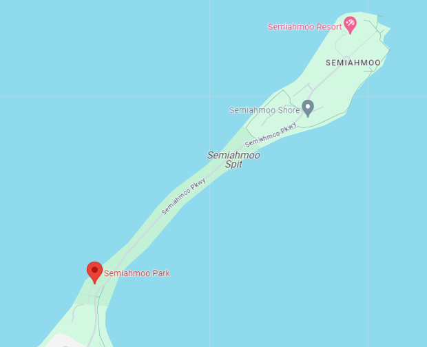
The above map shows where Semiahmoo Park is located along the Semiahmoo Spit. Semiahmoo Spit is a spit that protrudes from the westernmost expanse of shore on Semiahmoo Peninsula between Semiahmoo Bay and Drayton Harbor off the coast of Blaine in Whatcom County, Washington state. The spit is home to Semiahmoo Park. Below is the park entrance to Semiahmoo Park.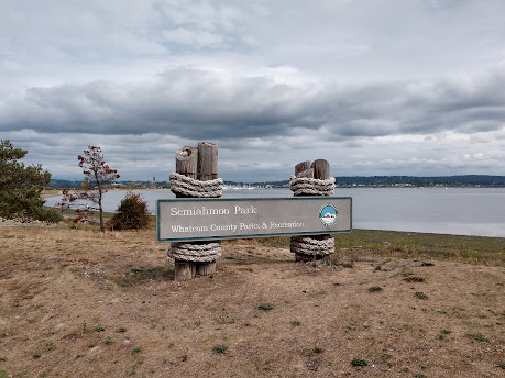
In 1858, prospectors came to the Semiahmoo area searching for the Fraser River. The spit seemed like a logical place to set up a post as a launching point for further exploration into the mainland. A trading post was soon established at the spit, and the owner drew up plans for Semiahmoo City. Semiahmoo was expected to become a migration boomtown, but it eventually developed into a fishing town, as the spit provided shelter for Drayton Harbor and an abundance of coastal resources.
(Semiahmoo Cannery Office, ca. August 1918.)
Whatcom County's first salmon cannery opened in 1881 in Semiahmoo; in 1891, the Alaska Packers Association was the largest salmon cannery in the world. Salmon canning was to be the main source of revenue in Semiahmoo until 1980, when the land was purchased by the land development corporation.
("Native quarters" at the Semiahmoo Cannery.)
Because of its location, the spit provides access to countless resources that thrive in both the calm waters of Drayton Harbor, and the ocean currents through the Strait of Georgia. Historically, the Lummi Indian Nation used the spit for its natural resources, where a major village was built on the spit. Today, shell midden is clearly visible in many places, on either side of the spit, as wave action has cut away at the shore, revealing historic artifacts.
Located in the most northwest corner of Washington State, the Northwest Necklace is a name coined for the approximately 8 mile loop which encircles the shoreline of Drayton Harbor stretching from the Blaine marina (called Blaine Harbor) around to the end of Semiahmoo Spit. And like gems adorning a necklace, there are a multitude of places to stop along the way to explore this rich diversity of northwest life.
The above storyboard told us about the Northwest Necklace. The Northwest Necklace stretches from the tip of Semiahmoo Spit, around Drayton Harbor, to the Blaine Wharf District, with the historic Plover Ferry closing the clasp across the throat of the harbor.
This interlocking chain of habitats and communities bring together air, soil and water, plants and animals, people and places, woven together into a rich fabric of life. The harbor's fertile seabed is home to meadows of eelgrass that provide food and shelter to young fish, carb and a legion of marine life. This aquatic breadbasket has fed Coast Salish peoples and settlers from Iceland, as it still does birds of the Pacific Flyway and other fanciers of fresh Northwest seafood. So wiggle your toes in the sand at low tide. View magnificent eagles circling the sky. Count dozens of diver and dabbler ducks feasting on the harbor's eelgrass meadows while you harvest clams. Learn how generations have been sustained by this unique area.
Above and below is the Drayton Harbor.
Above is the marina store at the Drayton Harbor.
The iconic rusty Semiahmoo Water Tower landmark (shown above) of the Semiahmoo spit was probably built between 1900—1920. It is made of steel (with the first elevated steel water towers being built around 1895), with structural steel legs — not a standpipe as you usually find around here.
The Semiahmoo Water Tower was built to give the cannery water pressure to process salmon—they filled them up each night for the next day’s processing. The Semiahmoo Spit became a trading post for prospectors around 1858, and eventually, Whatcom County’s first salmon cannery opened in 1881. In 1891, the Alaska Packers Association was the largest salmon cannery in the world.
Mel stopped to take a picture of the harbor.

Next, we rode our bikes by the historic Semiahmoo Cannery. Whatcom County’s first cannery was opened in August of 1882 by James Tarte and John Martin in Semiahmoo. In 1891, Daniel Drysdale built a small cannery at the end of Semiahmoo Spit (later known as the Alaska Packers Association) that packed 7,369 cases of sockeye and 1,457 cases of Coho salmon in its first year. In 1893, the cannery packed 36,244 cases of sockeye. During the mid 1950s APA packed 100,000 cases of salmon in 1 season. APA operated a cannery on Semiahmoo spit for 75 years. The cannery was sold to the Trillium Corporation in 1982. Today, it is the present site of the 4-star resort -- the Inn at Semiahmoo.
Shown above and below is the remnant of the world's largest cannery, the Semiahmoo Cannery, that later became the Alaska Packers Association.
The historic Plover Ferry (shown below) leaves from this dock area most days in the summer.
The MV Plover is an 11-ton, 17-passenger ferry in Whatcom County, Washington built in 1944 that was listed on the National Register of Historic Places in 1997. She is owned by the City of Blaine, Washington and operated by the nonprofit Drayton Harbor Maritime. She originally ferried workers from Blaine to the Alaska Packers' Association cannery at Semiahmoo Spit (now the site of Semiahmoo Resort), carrying out this function until 1964. She was restored by volunteers of Whatcom Maritime Historical Society, and now carries passengers during the summer months from the Blaine harbor dock across Drayton Harbor to the resort dock. At approximately 1 kilometer, this is claimed to be the shortest ferry run in Washington. She is the second oldest operating foot passenger ferry in Washington.

Shown above across the Semiahoo Bay is White Rock, a city in British Columbia. It borders Semiahmoo Bay to the south and is surrounded on three sides by Surrey. To the southeast across a footbridge lies the Semiahmoo First Nation, which is within the borders of Surrey. Semiahmoo Bay and the Southern Gulf Islands in the Strait of Georgia are also to the south.
White Rock is named for a large white boulder on its beach near the promenade, a glacial erratic that migrated south during the last glaciation. The 486-ton granite boulder was kept white by shellfish-eating seabirds whose guano covered the rock so much that 19th-century sailors used it as a beacon. It is now kept white through monthly applications of white paint by the city parks department and has been a graffiti target.
(Aerial view of White Rock, British Columbia's waterfront.)
The Straits Salish people dominated the region from Boundary Bay in the north to Birch Bay in the south (in the U.S.). Semiahmoo First Nation permanent encampments were known to exist between 1791, the first European contact, and the 1850s, the beginnings of European settlement. These were located along the waterfront at the eastern and western limits of the present City of White Rock. The Semiahmoo people also constructed forts as lookouts for raiders from the northern first nations; one is located in the Ocean Park area.

After we left the beautiful harbor area, we continued with our bike ride. As shown below is a distant picture of White Rock, British Columbia.
Our afternoon bike ride took us almost an hour and 15 minutes round trip for the 10.76 miles we rode. See the GPS screenshots below.
What a great bike ride we had today! For dinner tonight, we had steak and seasoned potato wedges.
Tuesday, September 12, 2023
This morning we had a delicious breakfast of a toasted English muffin topped with Canadian bacon, fried egg and cheese. Since the day started out a cloudy 57 degrees, we hung around the camper in the morning.
Around noon, we decided to drive into Taco Bell in Blaine, Washington and have the cravings box for lunch. Then we drove back to the campground, and started getting things ready to travel for tomorrow. Later for dinner, we had homemade tomato soup.
We settled in for a wonderful night's rest after having seen such majestic sights over the last few days here in the Blaine, Washington area.
Shirley & Mel


.jpg)


.jpeg)
.jpeg)


.jpg)


Wowyour photos are unbelievable beautiful. Each one is perfect. The colors are vivid and your descriptions are amazing. I keep thinking which area do I like best and couldn't answer. The waterfalls are beautiful and the flowers are gorgeous. The majestic mountains in the background are beautiful. I love it all. What a wonderful blog you have and so educational. 😊
ReplyDelete