Today it was still smoky outside, but the sun was shining brightly and it was a gorgeous 63 degrees. You can't beat that at the end of July. We took off at 8:45 a.m. for our journey along the "Top of the World Highway."
The name of the highway isn't completely arbitrary -- because for most of the ride you drive along the peaks and crests of mountains and hills, proving a magnificent view of the valley below. Even though this highway is only open in the summer months, the 79-mile gravel road has some spectacular views of the Alaska Range, and it can take you on your way to Dawson City in the Yukon.
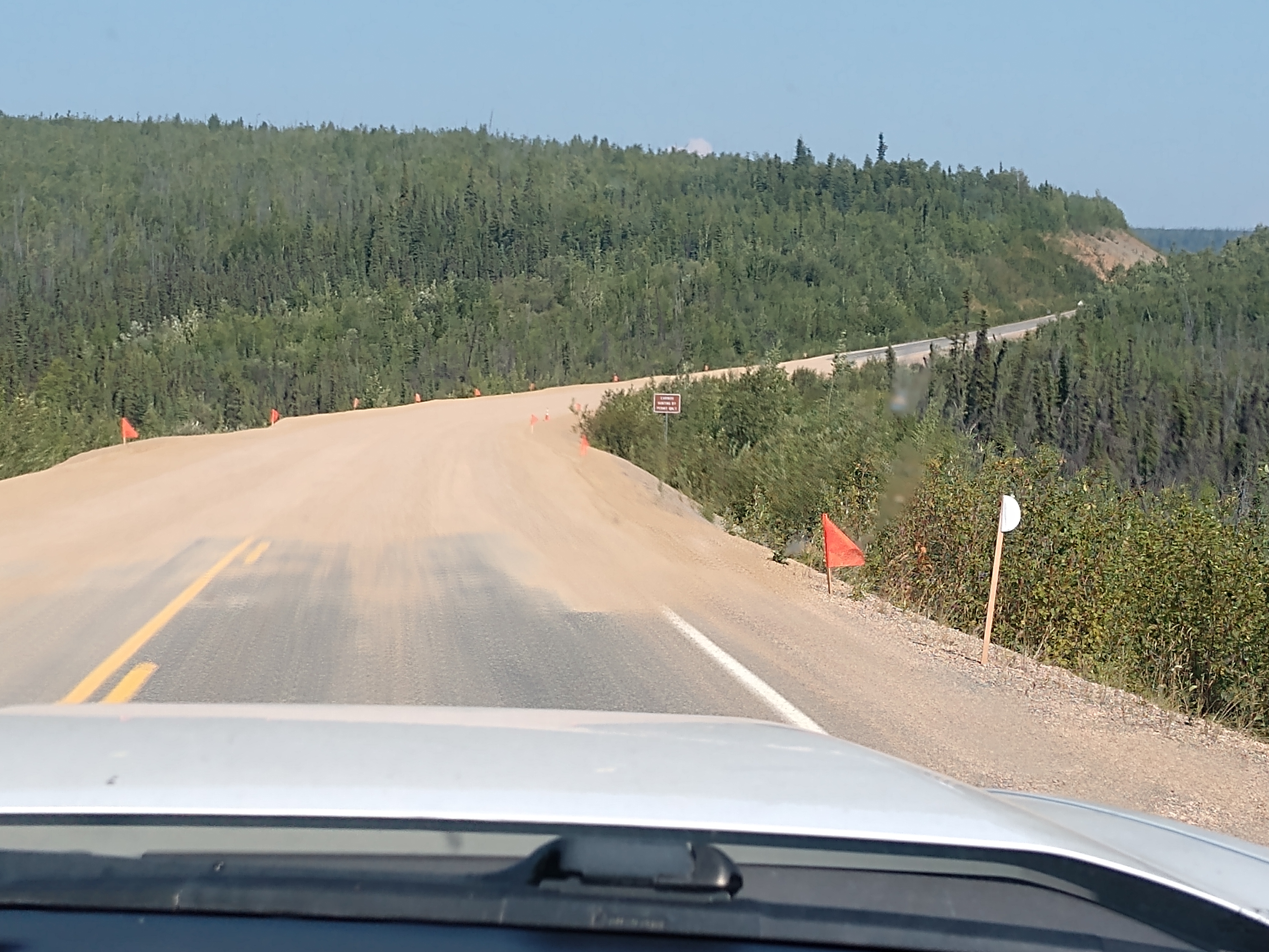
The "Top of the World Highway" has both paved and unpaved sections, but the majority is gravel. The road is narrow, without much of a shoulder, and plenty of potholes and surface breaks -- making for slow driving.
The latitude of the most northern point along the highway is 64.233, which is just a couple degrees south of the Arctic Circle at a latitude of 66.30. There are only two highways in North America that go further north -- the Dempster Highway in the Yukon and the Dalton Highway in Alaska. The highest summit of the "Top of the World Highway" is at 4,515 feet (at Km 104 near the Alaska/Yukon border).
We began our drive on Alaska Highway 2 South going toward Dot Lake and Tok Junction.
Dot Lake has a population of 13 and was first homesteaded in the 1940s, and was originally a work camp called Sears City during the construction of the Alaska Highway in 1942.
We crossed the Johnson River Bridge on the Alaska Highway. The Johnson River is a tributary of the Tanana River. The bridge is composed of five Warren trusses, with a total length of 974-1/2 feet.
Above and below are views of the Johnson River from the bridge.
We are now 71 miles from Tok.
Then about 15 minutes later we came upon another bridge crossing the Johnson River -- however this bridge had wooden planks.
Shown above is the beautiful Johnson River and then shortly thereafter, guess what -- more road construction.
And it is sloppy and wet because they are watering down the road.
Next we crossed the Robertson River -- which looked a lot like the Johnson River.
We are now 42 miles until we reach Tetlin Junction where we will turn off on Taylor Road (aka "Top of the World Highway").
You can see the smoky haze in the air along the Alaska Highway.
We're now about 20 miles from Tok Junction, but we have run into road construction again!
We now passed the Tanacross turnoff. Tanacross has a population of 144 and is a traditional Athabascan community.
As we had briefly been in Tok before, we are not going to stop very long time but instead quickly get gas at the Three Bears Alaska Outpost.
Tok has a population of 1,435 and an elevation of 1,635 feet. Tok began as a construction camp on the Alaska Highway in 1942. Tok is the only town in Alaska that the highway traveler must pass through twice -- once when arriving in the state and again when leaving the state.
Tetlin Junction is now only 12 miles away.
Above is the bridge over the Tok River at mile 1309 of the Alaska Highway that was named the Scott Johnson Memorial Bridge as a memorial to Trooper Scott Johnson that was killed while investigating a report that a person had brandished a firearm in the village of Tanana on May 1, 2014.
We're now at Tetlin Junction at Mile 1302, and have turned North onto Taylor Highway 5 (also known as the Top of the World Highway).
Now abandoned, the Tetlin Roadhouse was a busy truck stop and overnight destination for travelers of the Alaska Highway and the Taylor Highway.
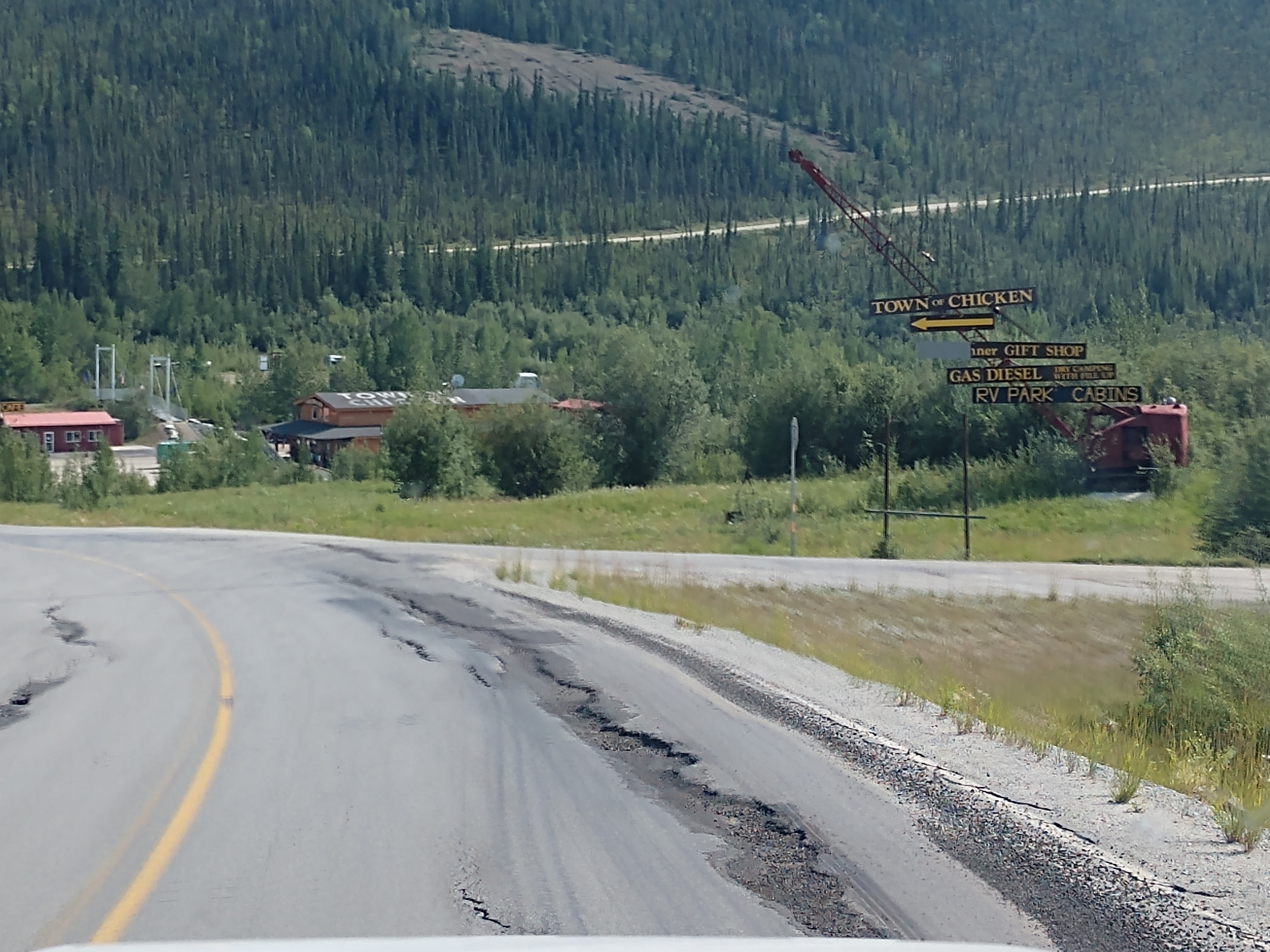
Chicken is now 66 miles away.
Mel has become a little leery of the different colored patches of road along the Taylor Highway.
We have now run into signs saying "loose gavel ahead" and the road becomes very dusty in these areas.
All along Taylor Highway, the hills continue on going up and down. It makes us truly feel like we are on the "Top of the World ."
And the scenery is absolutely beautiful all along, but we only wish the road was in better shape!
At mile 35 on the Taylor Highway at the Mount Fairplay Wayside (BLM), we pulled over to eat lunch. We had gone only about halfway to Chicken and it had been slow going due to the road conditions. We expected it would be another couple hours before we got to Chicken.
The fireweed and the mountains were simply beautiful from this pullover.
We also got to read about the Taylor Highway on the story board here:
"Taylor Highway leads through some of the earliest and richest gold mining country in Alaska to the city of Eagle on the Yukon River. Gold was discovered by Franklin in 1888, and the old town of Forty Mile was located on the Yukon River at the mouth of the Forty Mile River. A river boat trip from Eagle will take you to this historic town. The Chicken Creek area was also a rich gold mining area at about the same time Wade Creek was another rich area and the remains of an old dredge still stand along the road. The old horse and wagon trail used by the early day miners and freighters is still visible in many places and the present highway often parallels this trail. The largest herd of caribou in Alaska crosses the Taylor Highway each fall on its annual migration. This is truly a sportsmans paradise with an abundance of fish and game."


Along the way we entered inand out of federal subsistence hunt areas. The subsistinence way of life by rural Alaskans on Federal public lands and waters helps maintain healthy populations of fish and wildlife. Subsistence fishing and hunting provide a large share of the food comsumed in rural Alaska. The state's rural residents harvest about 18,000 tons of wild foods each years -- an average of 295 pounds per person. Fish makes up about 56 percent of this harvest statewide. Nowhere else in the United States is there such a heavy reliance upon wild foods.
We once again came to more road work ahead as we crossed the Logging Cabin Creek.
We followed the pilot vehicle through the road construction area.
Within a very few minutes after we had gotten through the last road construction area, we came upon a "rough road" area.
We crossed the brige over the West Fork Dennison River (see below).
The road ahead continued to be quite rough.
We crossed Taylor Creek.
The road turned to pretty much gravel at this point.
We passed the turnoff for the Mosquito Fork Bridge Wayside. Mel jokingly said, "Who would want to go there if you are going to get bit by mosquitos."
At mile 66, we finally arrived at the community of chicken, home of the Pedro Gold Dredge and Tisha's Schoolhouse. We stayed at the Downtown Chicken area where there were a few free overnight parking spots along the side (with boondocking only). But it was free, so you can't beat that!
Chicken has a population of 23 in the summer and 7 in the winter. Given the town's small size, the most obvious way to get around is by foot. It is located at milepost 66 on the Taylor Highway. Established in 1898, it's one of Alaska's surviving Fortymile-area gold rush towns. The original settlers wanted to call the town Ptarmigan, but none of them could spell the word, so they settled on Chicken.
Mining began in the area in 1886, with the discovery of gold on Franklin Gulch. An estimated 700 miners worked the area until 1898, when many left for the Klondike Gold Rush. The post office was established in 1903. The original townsite is abandoned and is located on the west bank of Chicken Creek on the north side of the highway on private property.
Chicken is probably best know as the home of the late Ann Purdy, whose book, "Tisha," was based on her experiences as a young schoolteacher in the Bush. Tisha's schoolhouse and he former F.E Company gold camp comprise Old Town Historical Chicken.
(Above is a sketch of the Old Chicken schoolhouse.)
"Tisha" is the beloved real-life story of a woman in the Alaskan wilderness, the children she taught, and the man she loved. According to Anne Hobbs Purdy, "From the time I'd been a girl, I'd been thrilled with the idea of living on a frontier. So when I was offered the job of teaching school in a gold-mining settlement called Chicken, I accepted right away." Anne Hobbs was only nineteen in 1927 when she came to harsh and beautiful Alaska. Running a ramshackle schoolhouse would expose her to more than just the elements. After she allowed Native American children into her class and fell in love with a half-Inuit man, she would learn the meanings of prejudice and perseverance, irrational hatred and unconditional love. "People get as mean as the weather," she discovered, "but they are also capable of great good."
The town of Chicken is just ahead.
We have arrived at the town of Chicken!
(Left is the Pedro Dredge, while across the road is the Chicken Creek Cafe complex.)
(Maps above and below show locations of the various areas of Chicken.)
Above and below is the Gold Panner Chicken RV Park -- although we didn't stay here, we wandered around a little looking at all the chicken things around.
Below are wooden chickens pulling a sled -- so looks like it's a chicken sled instead of a dog sled in Chicken, Alaska.
Above is a close-up of a multi-colored chicken on the porch of the Gold Panner RV Park Office & Gift Shop, while below is a wooden statue of a gold panner.
And they also have a penny-smashing machine here at Chicken.
Shown above are a couple more metal chicken statues. From the selfie below of Shirley, you can see they are fairly tall.
There's is also a wooden egg that says, "I got laid in Chicken Alaska."
And at this RV Park -- which is in a part of the town of Chicken -- there is a suspension bridge that goes across Chicken Creek to the cabins. It is built on the tailings of mining operations that once took place here, and now provide a shortcut between parking/ camping areas on the north side of the creek and amenities on the south side.
We then drove over Chicken Creek.
And followed the road until we came to the sign pointing to the left to Downtown Chicken.
We drove past the Chicken Gold Camp and Pedro Dredge National Historic Site signs.
Above you can see Downtown Chicken in the top center of this picture, with the Pedro Dredge in the bottom left corner.

The Chicken Creek Cafe, Mercantile Emporium, and Saloon are all located in Downtown Chicken. The cafe is famousfor its bakery, chicken pot pie, and famous homemade chicken noodle sout. Everything is made daily from scratch. The Mercantile abounds with original items prepared and designed by owner Susan Wiren (aka Chicken Sue).
(Susan Wiren at Downtown Chicken.)
Chicken Sue is a Philadelphia native who has been operating Downtown Chicken (the remanants of old frontier Alaska) for the past 35 years. The weathered-looking storefronts as set admidst a stark landscape including a souvenioremporium with t-shirts that read, "I got laid in Chicken, Alaska" or "Cluck-U."
Above is our first close-up of Downtown Chicken that I tood a picture of while Mel went to find out where we can park for free tonight.
We are told we can park on the right side just past the cafe. As we are getting set up, I noticed the small tent right across from us -- it appears he plans to walk around the World from Alaska to Argentina. Technically it would be physically possible to walk from Anchorage, Alaska to Ushuaia, Argentina. However the journey would span approximately 14,000 miles and cross multiple countries, terrains, and climates.
After we go all set up, I walked around taking a few more unique pictures of Downtown Chicken
The lone public restroom is a three-door outhouse that sits under a big sign reading, "Chicken Poop." The double O's are drawn as chicks hatching from eggs.
Beautiful Downtown Chicken is really a four businesses -- Chicken Mercantile Emporium, Chicken Creek Cafe, Chicken Saloon and Chicken Liquor and has become a "must stop" when driving in this part of the world. Even tour buses stop here.
Above I found this document with "Chicken Facts "in the Chicken Mercantile, while below I found a lot of other mercandise (see below).
Standing at the lunch counter of the Chicken Creek Cafe, it is hard to decide what to order. For such a small cafe, there are so many offerings, many including chicken as a main ingredient.
And don't forget the homemade fruit pies or brownies with a scoop of ice cream.
There are even daily specials including chicken noodle soup.
As I said before, this cute, quirky Downtown Chicken is made up of a poultry -- er, a paltry four businesses. But when things get wild in the Chicken Creek Saloon, local tradition dictates that ladies donate their underwear or panties to a small cannon, which blasts them into shreds over the parking lot.
As evidence would prove, many panties have been donated for such an occasion as you can see for yourself when you walk into the Chicken Creek Saloon. The ceiling of the saloon is festooned with thousands of panties donated to the "Panty Cannon." Some say it's a tradition for road warriers from Canada with the "dead butt syndrome" to celebrate their arrival in Alaska by blowing up their underwear.
While we were in Chicken we met a couple from Dawson City, Yukon -- Rebecca and Eric. The bartender and Eric convinced Rebecca to take part in the "panty cannon" ritual. So we could to see this first hand.
Above is what the "panty cannon" looks like. The cannon itself is a simple metal cylinder with a couple of holes in it, but it was the cannon fodder that made this weapon unique -- as it shot out a pair of underwear.
Rebecca wanted to light the "panty cannon."
And then lots of smoke and a loud BOOM! And Rebecca goes to retrieve her blown up panties.
Rebecca giggles and then goes to find a 'respectable" place to hang her blown-up panties in the saloon.
After all that excitement, we decided to find something to eat in the cafe. Mel got bison chili as shown below.
And Shirley got Chicken Sue's famous chicken pot pie.
After dinner at around 5:30 p.m., we decided to walk over to the Chicken Gold Camp & Outpost and see the Pedro Dredge. The Gold Camp & Outpost was built on the site of a placer gold camp established in the 1930s by the industrious Fairbanks Exploration Company for prospecting and mining Chicken Creek with the Pedro Dredge. The dredge is a bucket line gold dredge that is now a National Historic Site.
Above and below are some of the old relics from the gold camp mining days.
Until 1998, Dedge No. 4 or the Pedro Dredge at Chicken was hardly visible, resting on upper Chicken Creek where it had been parked in 1967. In the fall of 1998, the dredg was moved a mile to its present location. The million-pound artifact was moved in one piece and took less than two weeks of preparation and two weeks of actual moving, during which 120 tires were used to support it.
The Pedro Dredge was owned by the Fairbanks Exploration Company, but only spent 1/3 of its operating life on Chicken Creek. The 3-cubic-foot dredge is the smallest in the FE Company's dredge fleet, and was originally built to mine the fairly shallow gravels of Pedro Creek north of Fairbanks.
The Pedro Dredge, originally driven by steam, was built by the Yuba Manufacturing Company in California, and was shipped from Oakland on the S.S. Point San Pablo on April 1, 1938. It was assembled on Pedro Creek and began operating on July 11, 1938. The dredge operated on Pedro Creek, with the exception of the war years, until October 1958. Having completed its available ground there, it was decided to move it to Chicken Creek, as the Cowden Dredge, also belonging to the company had suffered from years of neglect. It still rests in the Mosquito Fork of the Fortymile River.


The Pedro Dredge was disassembled on Pedro Creek and trucked to Chicken beginning in June 1959. The move and reconstrution were completed by September 1959 at a cost of $148,095. The dredge commenced operations on lower Chicken Creek in September and worked approximately five month every year thereafter until October 1967, when it produced its final cleanup.
During its production years on Chicken Creek, the dredge washed about 2,500 cubic yards of gravel each day (29 buckets per minute) at a cost of around 30 cents per cubic yard. Between 0.30 and 0.80 ounces of gold were recovered from each cubic yard of gravel. There were normally 16-20 men employed in the operation, with 10-12 involved directly with the dredging and the remainder mostly associated with thawing ground ahead of the dredge. The dredge mined over 55,000 ounces of gold in the eight years on Chicken Creek.

Just within an eyeshot of the large chicken statue, you can see the hulking behemoth os steel -- the Pedro Dredge. The Chicken Gold Camp claims it to be "the most complete bucket line gold open to the public in Alaska and perhaps in North America."
Below is the big metal chicken in Chicken, Alaska.
A huge fourteen-foot, orange and multi-colored metal chicken named "Eggee" is perched on a hill overlooking the Pedro Dredge at Chicken Gold Camp in Chicken, Alaska. The giant metal statute immortalizes the humorous naming story of Chicken. The metal statue was created by high school students from recycled school lockers and presented to the Chicken Gold Camp, which sponsors the annual Chickenstock Music Festival. Next to this huge chicken is a signpost designating the mileage to worldwide towns having chicken related names as "Chickaboogalla, Australia (6762 mi)," "Chicken Gizzard, KY (2951 mi)," and "Cluck, NM (2535 mi)."
Above are pictures of the Chicken Gold Camp & Outpost, while below is a big yellow chicken holding a gold pan with gold.
Below is an interesting quilt I found inside the store at the Chicken Gold Camp & Outpost.
And also at the Chicken Gold Camp & Outpost, we saw the stage that is used for the annual music festival held here every sunmmer in June called "Chickenstock" (get it -- like Woodstock). In keeping with the quirky, fun-loving character of the community, the folks at Chicken Gold Camp put on this annual music festival usually the 2nd weekend in June.
The Chickenstock Music Festival started as a one night, one band get-together in 2007, but is now one of Alaska's better known summer weekend musc gatherings with 15 or more bands entertaining over 1,000 guest who all camp together in the RV Park, campground and Chicken creek Valley. At the festival, they also have an aerial "chicken peep" drop for the kids and of course the "chicken dance" is led by "chickaneers."
To commemorate our one-night stay in Chicken, Alaska, Mel and Shirley got t-shirts. (See above for the t-shirt Shirley got, and below for the one Mel got.)
You know the old saying, "Don't count your chickens before they hatch," well I am not sure how many chickens we saw while in Chicken, Alaska.
Anyway, cluck, cluck, cluck -- that's enough chicken stuff!
Shirley & Mel


No comments:
Post a Comment