The giant woolly mammoth statue above is perched on the grass across from the Commissioner's Residence in Dawson City. The 5-1/2 ton and almost 10 feet tall Ice Age creature was created by Halin De Repentigny in his backyard in 2020 using cement, rebar and wire mesh and a ferro-cement method. De Repentigny is a Dawson City-based artist, whose artwork and style is iconic in the Dawson City region. The woolly mammoth is meant to greet visitors with a mammoth welcome to Dawson City!
The storyboard above tells about the floods in Dawson City. Dawson City has been flooded 22 times since the townsite was established on a low-lying flood plain in 1896. Many of these floods were minor, but five major events caused extenswive damage to the town. On the Yukon River, the most severe floods happen because of ice jams during spring break up. Blocks of ice pile up in narrow or shallow parts of the river; water builds behind these ice dams and causes floods.
On May 14, 1925, much of the town lay under water to the depth of more than 3 feet, especially to the south end, where buildings floated from their foundations.
A massive ice jam in 1944 left Dawson City knee-deep in water, and for days it showd no signs of breaking. The Royal Canadian Air Force in Whitehorse was called on for help, but several bombs dropped from a B-25 failed to break the jam.
The worst event occurred in May 1979. Ice jams in the Yukon, Indian and Klondike Rivers caused the water to overflow the makeshift sandbag dikes along Front Street. Streets were flooded all the way to 6th Avenue, in some places to a depth of 6 feet. Though the water flowed over Front Street for just an hour, the extensive damage took years to repair. Within weeks of the 1979 flood, the hydrologists called for the construction of a new dike that was six feet higher. It was completed in 1987, and since then Dawson City has seen only flood-free springs.

The above storyboard tells us about the Dawson Dike. The first attempt to keep spring floodwaters at bay was made in 1959, when a dike was established by raising the level of Front Street. Ten years later, following two severe floods in the 1960s, the dike was raised again. In 1979, the dike was toppled by the worst flood in Dawson City's history. In 1987, a much larger dike was completed along the riverfront to protect the town. The Dawson Dike is designed to withstand a major once-in-200-year flood, an event that would raise water levels even higher than in 1979.
The above storyboard tells us about permafrost, or perenially frozen ground that is one of the things that defines the Canadian North. Permafrost occurs when the ground remains at or below a temperature of 0°C for a minimum period of two years. The soil above the permafrost that freezes and thaws every year is called the active layer. Permafrost occurs not only at high latitudes but also at high elevations.

The above storyboard tells about permafrost in Dawson City. More than half of Dawson City is built on permafrost that is about 120 feet thick and many thousands of years old. It extends from Church Street to past the ferry landing at the north end of town. The permafrost that underlies Dawson City is considered warm with temperatures ranging from -0.1°C to -0.2°C. This makes it vulnerable to thawing if there is any increase in surface temperature -- however Dawson City's permafrost is still largely intact. Permafrost in Dawson City is particularly ice-rich. When the ice melts, the ground loses volume, and the surface drops. Buildings tilt and lean as their foundations sink into the ground; roads buckle and water pipes snap. Many steps have been taken to make sure the ground remains frozen.

The George Mercer Dawson plaque above honors him as a geologist and surveyer. He was born August 1, 1849, and died March 2, 1901. He performed many early explorations in western North America and compiled numerous records of the native peoples. A portrait of him is shown below.
Dawson joined the Geologiocal Survey of Canada in 1875 and led many field parties in Canada's north and west. His work is credited as having laid the foundations of much of our knowledge of the geology and natural history of those regions. For example, during 1883 and 1884, Dawson traveled through the Canadian Rockies, where he mapped out the major mountains, mountain passes, and rivers. Some of the many peaks he charted were Mount Assiniboine at 11,870 feet and Mount Temple at 11,624 feet. As a result of his field research, a map of his work was published in 1886 covering the Canadian Rockies from the U.S. border to the Red Deer River Valley and Kicking Horse Pass.

Joseph Francis Ladue was born July 28, 1855, and died June 27, 1901. The Joseph Francis Ladue plaque above tells us that he was the founder of Dawson City. He had been a miner and trader in the Yukon since 1882. Arriving at the confluence of the Yukon and Klondike Rivers mid-August 1896 and hearing of the discovery of gold on Bonanza Creek, he immediately laid out a 160-acre townsite and hurried down river to Fort Constantine at the mouth of the Forty Mile to register his application with the North West Mounted Police. Upon his return, he constructed the first cabin in Dawson City. A portrait of him is shown below.
Leroy Napaleon "Jack" McQuesten was born in 1836 and died in 1909. He was an American pioneer exploreer, trader and prospector in Alaska and Yukon. He became know as the "Father of Alaska," and was known by other nicknames including "Yukon Jack," "Captain Jack," and "Golden Rule McQuesten." The Jack McQuesten plaque above tells us that he arrived in the Yukon in 1873.
Together with his partners Arthur Harper and Captain Alfred Mayo, he founded Fort Reliance on August 20, 1874 and a wide network of trading posts in the Yukon, often providing a grubstake to prospectors. He was the most successful financially of the trio, becoming a multi-millionaire by 1898 and buying a large Victorian mansion for his family when they moved about that time to Berkeley, California. A portrait of him is shown below.
Above is the park where the plaques are located.
The Yukon Hotel is a two-story, false-front log building and is one of the oldest buildings in Dawson City. It was constructed in 1898 by F.E. Binet and was originally known as the Binet Block. The second Commissioner of the Yukon, William Ogilvie, rented it as office space for Crown timer and land agents until 1900. It was then used as a residence before it
was sold in 1909 to Henry Freeman, who opened the
Miner’s Rest Hotel.
In 1931, the building was renamed
the Freeman Hotel.
Emma Wilson purchased it in 1934, after her adjacent
hotel burned. She renamed it the Yukon Hotel and
operated the business until 1957. Miners and others who
lodged here enjoyed this location because it was quiet
and provided more privacy than other downtown hotels.
The National Trust for Canada purchased the building
in 1975. Vacant and decaying, the building underwent
a complete rehabilitation and was fitted with six small
apartments.
The Yukon Hotel represents a typical commercial structure
built at the height of the Klondike Gold Rush. The building
was privately sold in 1984 and continues to operate as
a hotel.
This building was recognized as a National Historic Site
of Canada in 1982.

Straits Auction House and Second Hand Store (see below) was a boomtown structure built in 1901. The building is a
simple wood frame construction with false-front façade
typical of many commercial buildings in Dawson City
from that era.
Ebenezer Strait sold groceries, hardware, tobacco,
furniture, clothing, guns and ammunition until the late
1910s. The store had two paid employees in 1902,
when the incorporation of Dawson City led to a
tax increase from $150 to $500. Strait was one of the
41 merchants who kept their business open after this
increase.
Strait’s Second Hand, or the Guns and Ammo Building, as
it was also known, was abandoned for several years and
slated for demolition in 1971.
The picturesque building was a favourite with visiting and
local artists. Albert Fuhre, a local artist, headed a citizens
group to save it. The group raised the $600 purchase
price and donated it to the Klondike Visitors Association, who added temporary bracing, but left it tilted
to demonstrate the influence of permafrost on Dawson’s
structures.
When the bracing threatened to go through the fragile
tilted walls, Don Cox bought the building and straightened
it.


St. Andrew's Church above is also know as Building 12 and is situated on the grounds of the religious precinct of Dawson City. Built during a great period of expansion in Dawson City, it is a timber structure with a gabled and hipped-roof and features an asymmetrically positioned tower. St. Andrew's Church and Manse are very good examples of structures that illustrate Dawson City's rapid metamorphosis from a boisterous mining camp in 1897-1898, to a boomtown in 1898-1899, into a prosperous and respectable community by 1901. St Andrew's Church is a very good example of High Victorian Gothic architecture interpreted in wood. Rich detailing is evident in the nave's stained glass Gothic window, the pointed arches of the window, doorway, and tower ventilators, and also in the butress panels of the tower with its bell cast roof.

Above is Bishop Stringer's House. This historic home of Anglican Bishop Isaac Stringer
stands as a testament to the resilience of the man himself.
While the story of having to literally eat his boots for
survival during a disastrous trip can be read on the board
in front of the house, Stringer was much more than “the
Bishop who ate his boots.”
In 1892, Isaac Stringer was recruited by the Anglican
Church Missionary Society to work with the Inuvialuit
in the Arctic. He and his wife, Sadie, established a
permanent mission at Herschel Island–Qikiqtaruk using
donations from the crews of whaling vessels anchored in
Pauline Cove.
To fill some pressing needs, Stringer studied
dentistry while he was on leave. Sadie was a nurse.
In 1903, Isaac was suffering from the effects of snow
blindness and the family moved to southern Yukon. He
was posted to Dawson in 1907, where he called for the
recognition of legal status for First Nation people and
compensation for their land.
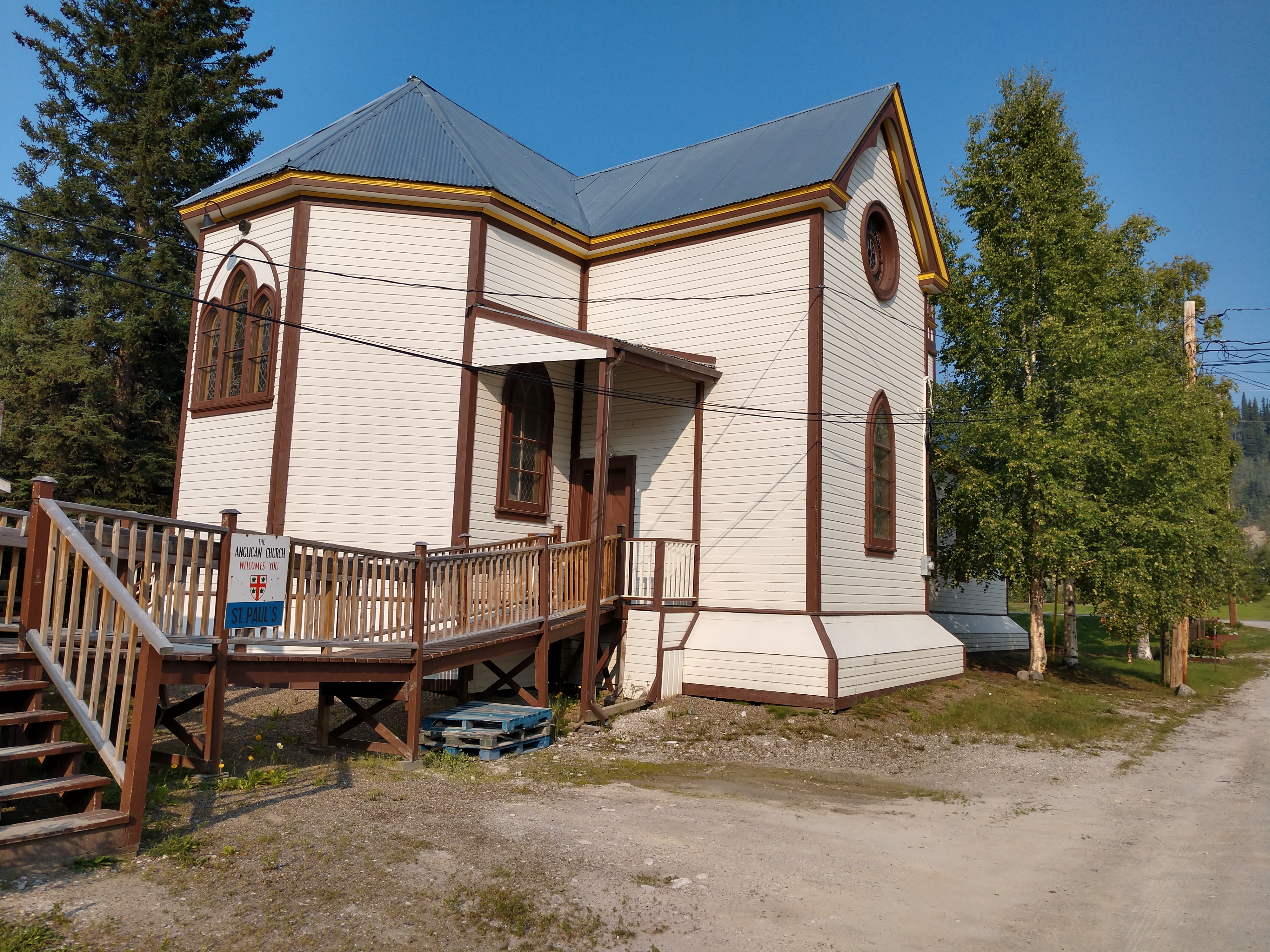
This building was constructed by barrister H.E. Ridley
some time before 1902. It was taken over by St. Paul’s
Church in 1905 and remains a residence in the care of
the Anglican Church.

Above is the Customs House, which is a good example of the remaining historic
residences in the area, with its corner lot, picket fence and
landscaping. An irregularly shaped three-bedroom frame
and log dwelling, the Customs House has undergone
extensive restoration and reconstruction. Virtually none
of its visible parts are original.
When constructed in 1902, it was a simple three-room
house with front and side verandas and a shed at the
rear. Slightly more elaborate than the many frame houses
of Dawson City, it had a roof with front and side gables, and
hipped slope at the back.
Through the years, this single-story building has housed
some of the people involved in providing supplies and
services to Dawson, including dentistry, hardware,
telephone operation, transportation and government. The
designation Customs House is a misnomer as it was only
used as the residence of the federally-employed customs
agent for a short time, from 1953 to the early 1960s.
Dr. John Brown and his journalist wife, Faith Fenton,
lived here. Fenton was Canada’s first female newspaper
columnist.
It is currently a private residence.

Above is the Henderson House. Prospector Robert Henderson built the upper level of this
house in 1901. Its design is representative of an upper
middle-class family dwelling in Dawson City at that time.
More recently, the owners felt the need for more space
and elevated the house, an elegant solution to preserving
the historic features of the original residence.
Henderson was a prospector in the area before the
Klondike Gold Rush. The Canadian government credits
him as a co-discoverer of the gold on Bonanza Creek
that started the gold rush, along with George Carmack,
Dawson Charlie, and Skookum Jim Mason.
In 1902, Henderson sold this house to George White
Fraser, Dominion Land Surveyor and Civil and Electrical
Engineer.
Later in the 1930s, it came back to the Henderson family
when Robert’s son, Grant, lived here. Grant Henderson
worked as an assayer for the Yukon Gold Company and
was active in mining in the area. Grant’s son, Chester,
grew up here and would go on to work for Yukon Gold
Company.

The Wyman House above is one of three located on the same block
with a similar size and style. These buildings are typical
of single-family dwellings in Dawson City in the early 1900s.
They’re located on small or partial lots and have small
landscaped yards. The addition of a wheelchair access
ramp and small studio on the back of the building have
allowed for modernization of the building while respecting
its early architectural style.
This single-story building was likely constructed by
Asa “Assey” Wyman in 1901 across the lot boundaries.
He did not purchase the second portion of the property
until 1903. According to local stories, this house was built
on top of a barge that came down river. The barge was
hauled to the site and the house built on it.

Above the storyboard tells about the Macaulay House (shown below). This fine two-story house, built in 1901, was owned by Henry C. Macaulay, Dawson City's first mayor. Subsequently, it housed such affluent individuals as a merchant, a Territorial Commissioner, a surveyor, and senior management of the Yukon Consolidated Gold Corporation. It was a resident for thos whoe insgtructions, salaries and life-style came from the outside.
This historic house has also housed many artists-in-residence over the years, and though its residents come from all over the world and at different times, all have similar stories of apparitions and presences. Residents have reported the apparition of a little girl in a period dress, and a figure seen on the stairs. There have also been reports of trouble crossing the landing of the staircase and seeing apparitions in a mirror in an upstairs closet. Spooky indeed!


The Tyrrell House above dates from the early 1900s. It was
originally located on Church Street. It is a squared, two-story log house with interlocking notches and a gable
roof covered with corrugated metal.
Canadian geologist J.B. Tyrrell constructed the house and
lived in it until 1908. Tyrrell had led a geological survey
over the Dalton Trail to Dawson City. His work, which included
an extensive photographic record and articles on mining,
enabled subsequent mining developments in the area.
He left the Geological Survey of Canada in 1899.
Afterward, he returned to Dawson City and worked as a
consultant engineer specializing in gold mining. He
eventually moved his headquarters to Toronto and passed
away there in 1957.
This house continues to be used as a private residence.

The Pinkerton House shown above is an important part of the historic character
of this area. Its hipped roof, open porch, wood framed
windows and wood siding are typical of early residential
properties in Dawson City in the early 1900s.
Although John Wallace Pike owned this property in 1902,
it is likely that he subdivided the land and sold the portion
on which this building is constructed to Bertram Pinkerton
in 1902. Pinkerton built this house as his residence, and
then purchased the adjacent north half of the lot in 1907.
Originally from Ontario, he came to Dawson City in search
of gold and prosperity but worked mainly in the mail
service and for the White Pass and Yukon Route.

The Berton House shown above is named for Pierre Berton, noted prolific
author of more than 50 Canadian history books. It was
built in 1901, and it became home to the Berton family in
1920—the same year Pierre was born. The family lived
here until 1932.
In 1961, Pierre’s mother, Laura Beatrice Berton, published, "I Married the Klondike," a vivid memoir of her 25 years in
Yukon.
The house was rehabilitated in the early 1990s to become
the Berton House Writers’ Retreat program operated by
the Writers’ Trust of Canada and the Klondike Visitors
Association. Since Berton House opened in 1996, authors
from as far as Japan have lived and worked here for
periods of a few months to a year. They also contribute
to the vibrant cultural life of Dawson City by giving readings
and hosting events during their residencies.
Two major renovations were undertaken to accommodate
the needs of visiting writers, but the exterior remains true
to the Berton-era. More information about Pierre Berton,
the writers-in-residence program and the history of the
house can be found on interpretive panels outside the
house.


Next, we stopped at Jack London Square to see the Jack London Museum and Cabin.
Jack London, author of "The Call of the Wild" and "White Fang," came to the Klondike Gold Rush in 1897 to search for gold. The site features a log cabon built with some of the original logs from Jack London's cabine, a food cache and a museum containing memorabilia of his life in the North.
The Museum has a collection of photos tracing London's journey to the Klondike in 1897. The exhibit links London's literature with the people he met and the events that occurred in the Klondike during the Gold Rush.
Famed author Jack London was born in California. In 1897
when he was 21, he hiked the Chilkoot Pass into the Yukon
River drainage. He stopped to guide other stampeders’ boats
through the treacherous waters of Miles Canyon/Kwäninlen—
which means “water running through a narrow passage” in
Southern Tutchone—and White Horse Rapids. Then he set
out for the Klondike to prospect for gold.
London only spent one year in Yukon. Disillusioned with gold
mining and afflicted with scurvy, he returned to California in
1898. London wrote two successful novels about the north, "White Fang" and "Call of the Wild." They are still in print and
have been translated into 50 languages. Currently, the Klondike Visitors Association operates and
maintains the Jack London Museum
The cabin was first discovered by trappers on Henderson Creek. It was rediscovered by historian Dick North, dismantled and moved to Stewart Island.
This cabin (above) was originally located at Henderson Creek in the Klondike goldfields. One half of the cabin was taken to Pioneer Square in Oakland, California—aptly renamed Jack London Square—and the other half with Jack London’s inscription on one wall was relocated here.
The cache (above) is a cabin-like structure on stilts that was built to keep food, furs and perishables away from bears and other wildlife.
The Telegraph Office shown above is a small-scale Neoclassical Revival building designed by Thomas W. Fuller and constructed in 1899.
It was originally located just east of the Court House, in
the Government Reserve.
Telegraph services operated from this location for 15
months before they were moved to the telegraph
annex of the Post Office, a more central location in
town. The Telegraph Office became Fuller’s construction
headquarters, office and residence.
In 1908, the MacLaren family bought the building and
moved it from the Government Reserve to its present
location. It continued as an upper-scale family residence
for the next 75 years. The Dawson City Museum has
used it for various purposes since the 1980s, and it has
undergone rehabilitation by the Government of Yukon.

The Dawson City Telegraph Office is a designated Yukon Historic Site. It was one of six Dawson City public buildings designed by Thomas W. Fuller and was the first project where he was given sole responsibility for design and construction. This is the only architecturally designed telegraph office in Yukon, and it illustrates the Canadian government’s confidence in Dawson’s continued prosperity. Fuller went on to become the Chief Dominion Architect for Canada. The Telegraph Office represents a major communications system connecting Yukon to the south and the extraordinary development of the historic 1,678-mile Dawson City-Ashcroft Telegraph Line.


The Troberg House shown above was constructed in 1902, and has been home
to many long-time Dawson residents over the years.
It is believed this house was first constructed as a
residence for H.D. Hulme. In 1904, it was purchased by
George Black, a prominent lawyer in Dawson. Black was
appointed Commissioner of the Yukon in 1912, and he
sold the house when he recruited a regiment and then
went overseas to serve in the First World War. John
Murphy bought the house in 1914. He had mining claims
in the area and later worked for the Yukon Consolidated
Gold Company. The Troberg family eventually bought the
house in 1921. Ralph Troberg was an active member of
the community, as well as the Yukon Order of Pioneers
Grand Historian.
While the house has undergone extensive renovations
over the years, its original style and character have
remained intact.

The Old Territorial Administration Building shown above and below was designed by Thomas W. Fuller in the Neoclassical style. Its construction in 1901 lent an air of permanence to the community and was intended to illustrate Canada’s sovereignty in the North. This substantial structure reflected Dawson City’s evolution from a booming mining camp to a prosperous capital with a promising future.
It was the legislative and administrative
headquarters of the new Yukon Territory, housing
government offices, as well as the territorial legislative
assembly.
The OTAB’s history over the next 60 years paralleled the
territory’s economic and political fortunes. By 1910, Yukon
was experiencing a critical decline, and the government
centralized its territorial and federal services into this
building. It remained the centre of the federal and territorial
government until the capital was moved from Dawson to
Whitehorse in 1953.

At various times, this building has been home to the local post office, a radio station, the tax collector’s office, and the public school. Since 1962, it has housed the Dawson City Museum. The OTAB was designated a National Historic Site of Canada in 2001. It is a symbol of the establishment of the first substantial, ongoing linkage between the northern territories and southern Canadian society, and it signifies the federal government’s commitment to the administration of this north-western part of Canada. It currently houses law courts, government offices, and the Dawson City Museum.


The Commanding Officer's Quarters (shown above), is also known as Building 10 and is located on 5th Avenue in Dawson City. The building is a two-story residence with a low, hipped roof and full width, front verandah. Tall sash windows are symmetrically arranged around the main front door. The Commanding Officer’s Residence is one of the best examples of a building associated with the North West Mounted Police (NWMP), in their role in the establishment of law and order and the exercise of Canadian sovereignty in the northern territories. The residence was built to accommodate A.E.R. Cuthbert who, in 1902, was commander of a force of 450 men stationed at the site formerly known as the Fort Herchmer North West Mounted Police complex. The building is also associated with the early development of the community. It was one of several permanent government buildings constructed in Dawson City during this period and a surviving structure from the Fort Herchmer complex.
In the 1940s the building was abandoned. It was acquired by Parks Canada in 1976 as a support building for Klondike National Historic Sites. Since that time it has been renovated into two apartments for the use as staff housing. At an early date the original wood shingle roof was replaced with pressed metal shingles. A wood shingle roof finish was reinstated in 1985. The building is currently owned by Environment Canada, Canadian Parks Service.
Mel is walking up to the Klondike Mines Railway Locomotive Shelter (shown above). Three Klondike Mines Railway locomotives, including one of the oldest preserved examples in Canada, are housed in the museum's train shelter.
Above and below are a couple of locomotives in the Klondike Mines Railway Locomotive Shelter.
Above and below is the Dänojà Zho Cultural Center. Dänojà Zho means “Long Ago House” in the Hän language. The center opened in July 1998 to share the history and stories of the Tr’ondëk Hwëch’in, and to open new pathways to reconciliation. The contemporary architecture reflects on the community’s ancestral connection to the land and dependence on the Yukon River for food and transportation.

Over the years, Dänojà Zho has become a meeting place
for public programming, education outreach and cultural
tourism. The center is a community gathering place where
the accomplishments of the Tr’ondëk Hwëch’in are shared
and celebrated.
The center was designed by Yukon firm Mauer and
Kobayashi Architects, and was awarded the Lieutenant
Governor of BC Award of Merit in Architecture in 1999.
It incorporates stylized fish drying racks and a traditional
hut in its design.
Visitors are encouraged to meet the Tr’ondëk Hwëch’in
staff and tour the Hammerstone and Gathering Room
Galleries. The center’s gift shop supports community and
Indigenous artists.


Above the K'ay Zho means "willow house," while below is the crest of of the Tr’ondëk Hwëch’in. The Tr'ondëk Hwëch'in First Nation is located in Dawson City and belongs to the Hän linguistic grouping which means, "the people of the Klondike River." The people moved to the Moosehide reserve, just downriver from Dawson City at the time of the Klondike Gold Rush. In the 1950s, and eventually, the declining population at Moosehide caused the Hän people to move back to Dawson City, where they have become an integral part of the community.
Above "Dähdräl" means cache.
Chʼòndèy means "medicine" with the Tr’ondëk Hwëch’in using plants and flowers.
The float plane (shown above and below) through Peel Wilderness Adventures is a tourism operator based in Dawson City. We have heard that they provide an up close and personal experience of what the Yukon has to offer, we were just excited to be able to see a float plane this close!
Above is the government offices of the Tr’ondëk Hwëch’in.
The Yukon Rose (shown above and below) was originally commissioned by Taylor and Drury in 1927, around the time that their previous vessel, the Thistle sank in Lake Laberge. Built in Vancouver, she was designed with a tunnel drive propulsion system. Simply stated, a tunnel drive is a recessed space on the underside of the boat that receives the drive shaft and propeller. Because it is positioned in a tapered cavity on the bottom of the Rose, the propeller is less likely to be damaged by catching on the river bottom.

The Yukon Rose embarked on her maiden voyage in July of 1929. She was stranded in the shallows of the Teslin River in the fall of 1929, laden with supplies destined for the Taylor and Dury Store in Teslin. According to Johnston, she sank again in the shallow water of Ice Chest Rapids on the Stewart River in September of 1936. She was chartered by the White Pass and Yukon Route at the time to pick up a barge load of ore. According to the Mayo Miner, "her rudders caught on the bottom and the stern had been stove in."

The Yukon Sawmill Company (shown above) represents the role that the lumber and
mining industries played in the growth and development
of Dawson City. Its expansion paralleled the town’s evolution
from mining camp to well-established supply center.
The Yukon Sawmill Co. was established in 1898 by J.F.
Burke and the Alaska Commercial Company. It was one of
the earliest sawmills to operate in the Dawson City area.
During peak production it had the largest machine shop
north of Vancouver, a foundry, and a lumberyard that
stretched over three city blocks.
By 1901, the new Yukon Sawmill Company Office, was
constructed at the corner of Duke and Front streets.
This
building housed the machine shop, sales area, offices and
storage.
The machine shop business expanded in 1902, reflecting
the change in the economy from supplying the building
construction industry to providing a much-needed supply
and repair service to the mining companies operating in
the Dawson City region.
The two-story building with oversize windows, hipped
metal clad roof and black lettering is a prominent feature on
Front Street. The facades and corner entrance are typical of
commercial properties built in Dawson City in the early 1900s.
Its high ceilings bring the building height to the equivalent
of a four-story structure, adding to its imposing presence
on the waterfront.
The company stopped operating sometime between 1919
and 1923.
By 1931, this building was being used as a
cold storage warehouse. It was purchased by the Cassiar
Asbestos Company in 1963.
The Yukon government acquired this building in 1967.
Since then it has undergone extensive restoration and was
designated a Yukon Historic Site in 2005.
The Dawson City Firefighters Museum is shown above. On Thanksgiving Day 1897, a fire spread through the center of Dawson City’s newly built town site, destroying its wooden
buildings and calling attention to the need for an organized
fire brigade.
By July 1898, the settlement had acquired a fire steamer
apparatus, a precursor to the fire engine, and by October of
1898 the Dawson City Fire Brigade began operations. It is
still operating today as the oldest fire department in Yukon.
Currently, it is run by volunteers under the direction of the
Dawson City Fire Chief.
The fire department also runs the Dawson City Firefighters
Museum as a non-profit organization. It houses an impressive
array of artifacts relating to Dawson City’s firefighting history,
including pictures, memorabilia and vintage fire engines.
The interesting collection of vehicles show the evolution of
firefighting in Dawson City. The restoration of the horse-drawn
Clapp and Jones Fire Steam Pumper was a major project
for the group.
Admission to the museum is by donation.
Above is an old 1897 Clapp and Jones steam pumper that has been restored and is on display at the fire department's museum in Dawson City.
The 3rd Avenue Typhoid Cemetery above is the oldes cemetery in Dawson City. It is next to where the old hospital was in the days of the Klondike Gold Rush. The cemetery is not maintained, with headstones dating back to 1897. The area is now overgrown
with spruce and poplar trees, and an undergrowth of rose
bushes. The burial plots are mostly unmarked, with a few
wooden headboards and fences surrounding the graves.

Early Dawson was not an easy place to live. Food was
expensive and of poor quality. The town was built on a bog,
with no facilities for sanitation.
St. Mary’s Hospital, a small log building run by Father William
Judge, was located nearby, and it was a very busy place. The
first burial in the cemetery was Bert Stickney, who died at age
26 on May 16, 1897. In October of that year, a government
inspection of the hospital resulted in a $7,000 stipend to cover
expenses involved in a typhoid epidemic. In 1898 and 1899, the
three doctors in town were overrun with rampant cases of
typhoid fever and scurvy.
We walked by where the North Avenue Trail began but because we had walked a lot already, we decided not to go on this 2-1/2 mile trail.
Above is the De Lion House. Business was good when George de Lion built this residence around 1902,
originally on Fifth Avenue. De Lion was an
affluent Dawson City business person who built the Villa de Lion
Hotel in West Dawson in 1899 and the Monte Carlo Theatre
downtown in 1900. De Lion also owned a ferry on the Yukon
River so patrons could cross the river to his hotel.
We went to see the grave of Father William H. Judge in Dawson City.

Father William H. Judge was a Jesuit missionary
who arrived in Dawson City in the spring of 1897 at the
beginning of the Klondike Gold Rush. He established a
church and hospital, tending to the medical and spiritual
needs of the town.
Judge worked tirelessly for others, helping everyone who
sought his aid, often to the detriment of his own fragile
health. He died of pneumonia on January 16, 1899 at the age
49. It is said that the town of Dawson City shut down on the
day of the funeral for the “Saint of Dawson.”
He was buried in the church on Front Street on the left
(gospel) side of the altar. The marble stone was added
in 1904, and it was left in place when the church was
demolished in 1923.
All that remains of the church is its sacristy, a room that
housed vestments and other items used in worship. The
priest would have used the room to prepare for a church
service.
In 1987, the federal government designated Judge as a
Person of National Significance for his life-long work.

The inscribed bronze plaque (shown above) was placed in a large boulder between his grave and the Yukon River i his honor in 1991 by the Historic Sites and Monuments Board of Canada. It reads:
William Judge, S.J.
(1850-1899)
Father William Judge is remembered as the "Saint of Dawson." An American Jesuit missionary, he went to Alaska in 1890 to work among the Indians of the lower Yukon. He moved to Forty Mile in 1895, and when gold was discovered near Dawson he followed his parishioners there in 1897. Judge devoted himself totally to the physical and spiritual well-being of the miners. He built Dawson's first hospital, St. Mary's, and for one year single-handedly ran both it and his church. He was well-loved by the local people and his death caused widespread mourning throughout the community.

Father Judge was buried in his little church, on the gospel side of the altar, with a marble stone erected a few years later. The church was torn down in 1923, but the grave and stone were left in place. The gravesite is on the other side of the small, white building and overlooks the Yukon River.
The text on the Yukon Government heritage sign above the grave is similar to the Latin inscription on Father Judge's headstone:
"Here is buried, until it rises up, the body of Father William H. Judge of the Society of Jesus (Jesuit). A man full of charity who in the city of Dawson, with the co-operation of all, erected the first house of the sick (hospital) and a temple of God (church), and who being mourned by all, died piously in the Lord in the 16th day of January 1899."
The inscription on the tombstone is in Latin - the translation is:
"Here lies the body of Father Wm. H. Judge, S.J., a man full of charity, who, with the cooperation of all, here first erected a house for the sick and a temple for God; and who, being mourned by all, died piously in the Lord, the 16th of January, 1899."
The Whitehouse Cabins (shown above and below) are located along a narrow curving road with landscaped
yards and mature trees. These five buildings have a sense of
timelessness. Now called the Whitehouse Cabins, they’re
available to rent as visitor accommodations during the
summer season.
Though the buildings have had various owners since
their construction, they’re named for Tr’ondëk Hwëch’in
citizen Joseph Edward Whitehouse. He was listed as the
proprietor in 1939, and again for numerous years from
1961.

Whitehouse was born near Dawson City in 1909.
His mother died in 1916, after which he lived in Prince
Rupert, BC, and then in England from 1920 to 1925.
Upon his return to Yukon in 1925, he worked as a
bookkeeper, raised and trained sled dogs, and had a mail
run.
In 1929, he worked on a dredge for Yukon Consolidated
Gold Company until he married Irene Silas in 1934.
He worked for Yukon government in various capacities,
finally becoming road foreman of the area from Stewart
Crossing north and west. In 1973, the Whitehouse family
retired to Whitehorse.
The style of this single-story log cabin is typical of the
early cabins built in Dawson City. While it was reconstructed
between 2004 and 2010, it still retains much of the
material from the original cabin. It is made with saddlenotched logs, chinked with lime compound and whatever
insulating materials were on hand, such as rags, newspaper,
and oakum. The railed balconies tie the two structures physically and
visually, maintaining the appearance and character Dawson City might have had between the 1920s and 1960s.
The 1899 Heritage House (above) is one of Dawson City's oldest original gold rush buildings. It has four spacious guest rooms — two are located on the ground floor and two are on the top floor. Referred to as the Whitehouse Cabins "apartments" by Irene Whitehouse during the 1950's, these guest rooms each have private front and rear entrances and sleep up to four people comfortably.
The Gold Rush Cabin (above) was built in 1897 and restored in 2005. It is also part of the Whitehouse Cabins. This historic log cabin is an exquisite suite with an elegant rustic interior decor. It features a queen-sized bed with down-filled duvet, an antique cast iron claw foot tub and pedestal sink, a full kitchen and dining area.
Above is Hän Fisheries. The first Tr’ondëk Hwëch’in government office opened in
this building in 1971. At that time the First Nation was
known as the Dawson Indian Band.
Respected Elder Percy Henry, who was elected Tr’ondëk
Hwëch’in chief in 1969, bought the building from the
Cassiar Asbestos Company for $1. Opening a dedicated
First Nation government office signaled the start of a
dramatic change in the governance structure of Yukon. It
foreshadowed the importance of the land claims and selfgovernment agreements that would follow.
After the government offices moved out, this building was
converted into a state-of-the-art fish processing plant.
In 1983, the Tr’ondëk Hwëch’in joined forces with the
Vuntut Gwitchin First Nation to create Hän Fisheries as a
complement to the existing salmon industry. It gave 15 to
18 fishers the opportunity to sell their catch for processing
and resale.
Salmon were caught with nets in the Yukon River below
Dawson City. Then the fish were picked up near the historic
town site of Forty Mile and transported to this building for
processing, packaging, and shipping.
Hän Fisheries was a reliable venture for numerous years,
employing 15 people on the processing line and providing
a stable market for fishers to sell Chinook and Chum salmon.
By 1987, Hän Fisheries began selling packed chum roe
caviar in American and Japanese markets. The operation
also expanded to a salmon retail shop on Front St. and a
salmon barbecue operation. A decline in salmon stocks led
to the closure of Hän Fisheries in 1997.
The building is currently being used for storage.
Above and below is the community Hall of the Tr’ondëk Hwëch’in.

The Bank of British North America (shown above) is situated on a once bustling intersection in Dawson City. It is a two-story timber structure, with a white-painted corrugated metal exterior, and features a pedimented gable roof, overhanging eaves and regularly placed windows. The Bank of British North America is one of the best examples of a structure illustrating the development of financial services in the North. The Bank of British North America was the first banking institution established in Dawson City in May 1898 during the Klondike Gold Rush. The structure was built as a combination bank, dormitory, assay office, and general office. The Bank is also associated with Alex McDonald, the "King of the Klondike" who directed his numerous mining and real estate ventures from the general office within the building. Dawson City metamorphosed from a boisterous mining camp in 1897-1898, to a boomtown in 1898-1899 when the bank was constructed and then into a prosperous and respectable community by 1901.

The Palace Grand Theatre (shown below) is an elegant three-story wood structure, rectangular in plan, which is characterized by the symmetrical arrangement of refined architectural features on its impressive false front façade. It was constructed in 1962 as a nearly exact replica of the original 1899 Palace Grand Theatre which having fallen into serious disrepair, was demolished. The present building is identical to its predecessor with the exception of some approximated interior elements and its distinctly modern components such as emergency exit additions to the east and west sides and service structures to the rear. The building is part of the Dawson Historical Complex National Historic Site of Canada, which commemorates Dawson City’s role in the Klondike Gold Rush.

Dawson City can be defined by three distinct phases: the boomtown of the late 1890s, the ghost town of the 1940s and 1950s, and its restoration by government in the 1960s. The reconstruction of the Palace Grand Theatre was the first step in the third phase, marking the beginning of the Dawson Historical Complex NHSC, its protection and tourism potential. It is one of the most prominent buildings in Dawson City and is one of the best illustrations of this significant phase of the City’s rebirth.
After we were finished with our walking tour, we got gas at AFD Fuel in Dawson City, and then went back to the camper for awhile. For dinner tonight, we had chicken and sweet potatoes fried on the grill.
Then at 7:30 p.m., we left to go see the shows at Diamond Tooth Gerties again tonight. When we got there, we secured the same seats that we had last night and prepared to hopefully watch all three shows (8:00 p.m., 10:00 p.m. and midnight).
Diamond Tooth Gertie was the some tonight, and so were most of the can-can girls, but the male lead singer was a different person.
I knew I was had, when I was given a "Diamond Tooth Gerties" garter by one of the dancers, Sierra. This meant that I would soon be up on stage.
And now my turn to be onstage with the can-can dancers -- we were told to do high kicks while lifting up our colorful skirts as we hooted and hollered! It was kind of scary, but a lot of fun! And of course, Mel took a couple pictures of me (see above and below).
After the first show was finished, we were able to take pictures of the performers (see above).
So Mel went up to get his picture takeen in amongst the dancers with two thumbs up!
The dancer Sierra Richardson (shown above with Mel and below with both Mel and Shirley) was born in Peterborough, Ontario, but is now based out of Toronto, where shis is pursuing her professional dance career. This was Sierra's fist season with Diamond Tooth Gertie's.
One show down, two to go. Mel went over to get us each a piece of pizza to enjoy between the shows.
And then the 10:00 p.m. show began, with the dancers in different customes that were a little more risque.
And guess what? Again tonight, we didn't make it to the midnight show as we headed home after the second show was over. We arrived back at the campground at 10:45 p.m. 


.jpg)


.jpg)


No comments:
Post a Comment