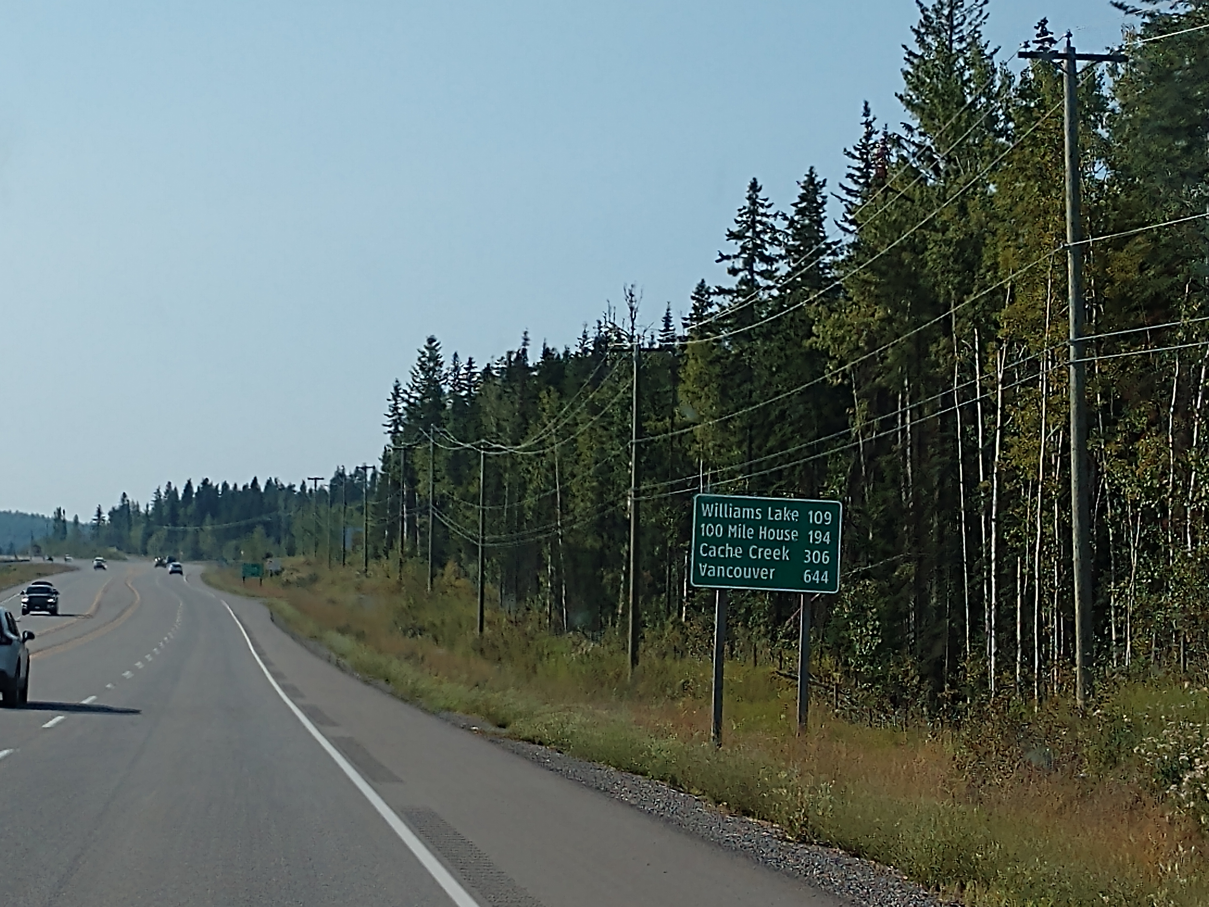
The smoke has been pretty heavy and still is as we leave this morning around 8:15 a.m. The temperature is a chilly 36 degrees, but the sun is trying to peek out -- however by the end of the day it is a sunny 81 degrees.
We are heading toward Washington state in the United States in hopes of outrunning the fires and smoke. (You will see lots of smoky pictures today.)

We have 303 kilometers (or 188 miles) to go to 100 Mile House. And yes, 100 Mile House is the name of a town.

Something they do differently here is that their 'weigh scales' as we call them in the U.S. are called 'median scales.' I'm guessing because they are off to the left in the median of the highway. Interesting, huh?


Quensel is now 85 kilometers (or 53 miles) away, while Williams Lake is 208 kilometers (or 129 miles) away.

As we continue down the highway, the smoke grows heavier.


Hixon is now 13 kilometers (or 8 miles away).


We have now entered Hixon, which is the small village on Hixton Creek and the Cariboo’s most northern community, where we were the other day when we tried to see Hixon Falls.

We are now 43 kilometers (or 27 miles) away from Quensel.


Quensel is just right ahead now.

We see some smoke in the air, but it is just from a power plant.


We are now in Quensel. Quesnel has a population of 10,561 and an elevation of 1,555 feet. It is located at the confluence of the Fraser and Quesnel Rivers . Quesnel’s first inhabitants were the First Nations people, commonly known as the Carrier. For thousands of years, they inhabited the territory, living off the land by hunting and fishing.

In the spring of 1857, gold was found in the Fraser River, imitating a gold rush with prospectors coming from all over North America to try and strike it rich. A major discovery in the Williams Creek area in 1861 marked the official beginning of the Cariboo Gold Rush, and the growth of Barkerville. Quesnel began as a supply town for miners during the Cariboo gold rush in the 1860s.

On June 19, 1987 the world’s largest gold pan was unveiled in Quesnel, British Columbia. The 3,000 pound big steel gold pan is 20 feet in diameter and accompanied by a giant mock gold nugget and a big shovel and pick. Across the front printed words declare the location to be “Gold Pan City.” The roadside attraction was created by Linden Welding, a local welding and machinery shop, and cost $20,000 to create in the late 1980s.
It’s only appropriate that Quesnel has this giant gold pan, as it is an essential stop on British Columbia’s Gold Rush Trail, an area that spans between New Westminster and Barkerville Historic Town following the Fraser River. The historic area played an important role for the Indigenous peoples’ fur trade and in the gold rushes of 1858-1862.
The city was named after the Quesnel River, which was named after fur trader Jules Maurice Quesnel, a member of Simon Fraser’s 1808 expedition down the Fraser River. Quesnel was incorporated as a village in 1928, and the following year a bridge was built which spanned the Fraser River. Today, forestry is the dominant economic force in Quesnel, which has pulp mills, a plywood plant, sawmills, planer mills and an MDF plant.
Explorer Alexander Mackenzie also left his mark here. Mackenzie, the first white man to cross the North American continent, left Lake Athabaska in 1793 to find a trade route to the Pacific. His journey took 72 days through 1,200 miles of unmapped territory.

Leaving Quensel, we followed Highway 97 South toward Williams Lake.


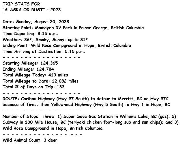
We are now 109 kilometers (or 68 miles) from Williams Lake.


We passed by Xat'sull First Nation (Soda Creek) that has a population of 454 and is located north of Williams Lake.

We are now at Williams Lake. We stopped to get gas at the Super Save Gas Station in Williams Lakes.
Williams Lake has a population of 10,753 and an elevation of 1,922 feet. It was named for Shuswap Indian Chief Will-Yum. The town began with the Cariboo gold rush in the 1800s, and grew rapidly with the advent of the Pacific Great Eastern Railway (later British Columbia Railway) in 1919. Williams Lake is a major cattle marketing and shipping center for the Cariboo–Chilcotin.


We followed Highway 97 South toward Cache Creek.

Cache Creek is now 202 kilometers (or 126 miles) away.


Above is a little pond by the side of the highway. We noticed a lot of yellow pollen on its surface.

On down the highway we go . . .


100 Mile House is now 12 kilometers (or 7 miles) away.


We stopped in 100 Mile House at the Subway for lunch and split a chicken teriyaki foot-long sub and sun chips.
100 Mile House has an elevation of 3,050 feet and a population of 1,200. It was established as a post house on the Cariboo Wagon Road to the goldfields. In 1930, the Marquess of Exeter established the 15,000-acre Bridge Creek Ranch here. Today, the 100 Mile House area has a lumber mill and an Oriented Strand Board plant. It is also the “hand-crafted log home capital of North America,” with an extensive log home industry.
An infestation of mountain pine beetle in British Columbia’s Interior has impacted forests and the timber industry in the province. Mountain pine beetles prefer mature (80 years or older) lodge pole pine trees. Lodge pole pine forest accounts for 25 percent of the province’s forestland (forestland covers two-thirds of the province). The mountain pine beetle epidemic is attributed to a number of factors including more mature lodge pole pine, successful firefighting, recent mild winters that have lowered normal mortality rates for beetle larvae, and trees weakened by recent drought stress.

Clinton is now 32 kilometers (or 20 miles) away.


Clinton has a population of 740 and an elevation of 2,911 feet. Clinton’s many antique and collectible shops do business on what was the original site of the 47 Mile Roadhouse, a gold-rush settlement on the Cariboo Wagon Road from Lillooet. Clinton boasts the oldest continuously held event of its kind in Canada, the Clinton Ball (in May, on the Saturday preceding Victoria Day). The ball has been an annual event since 1868 and is the first event of Western Heritage Week.

Cache Creek is now 39 kilometers (or 24 miles) away.


We continued on down the road.


We passed by the Historic Hat Creek Ranch that is located on one of the few sections of the original Cariboo Wagon Roads still accessible to the public. The ranch includes almost 320 acres of fields and hills in the sunny southern Interior of B.C. The buildings stand as they did in 1901; some were built as early as 1860. Between 1885 and 1905, they witnessed the busiest era of transportation along the Road, serving the needs of freight wagons and passengers of the B.C. Express line (The “BX”).
Hat Creek Roadhouse was famous for its hearty meals which were prepared from the ranch’s own produce, grown in a flood-irrigated garden and kept fresh in the recently restored Root Cellar. Chickens, turkeys, pigs and goats were raised in the 1898 Pig Barn and in the sod-roofed Chicken Coop built in 1872. Hat Creek House was established in 1861 by former Hudson’s Bay Company trader Donald McLean. What began as a small log stopping house later became a two-storied structure, and a west wing was added in 1901. It is the last remaining roadhouse of its type and one of the largest ever known along the Cariboo Wagon Road. McLean’s Cabin, originally built in 1863 at the confluence of Hat Creek and the Bonaparte River was moved to its present site behind the roadhouse in 1901.

We are now 11 kilometers (or 7 miles) away from Cache Creek.


We drove by this beautiful church.


We are now at Cache Creek. Cache Creek has a population of 1,050 and is located at the junction of Trans-Canada Highway 1 and Highway 97. At an elevation of 1,299 feet, Cache Creek is called the “Arizona of Canada,” as its climate is semi-arid, with hot, dry summers. It became a major supply point on the Cariboo Wagon Road. The settlement grew up around the confluence of Cache Creek and the Bonaparte River.


We are now at Ashcroft, BC. Ashcroft has a population of 1,558, and is a village in the Thompson Country of the Interior British Columbia. It is 19 miles downstream from the west end of Kamloops Lake, at the confluence of the Bonaparte and Thompson Rivers, and is in the Thompson-Nicola Regional District.
Ashcroft's downtown is on the east side of the Thompson River, although the municipal boundaries straddle the river, with housing and the town's hospital and recreation complex on the west bank. It is something of a "twin" to nearby Cache Creek, which unlike Ashcroft is on the major highway.

Ashcroft was named after the nearby Ashcroft Manor on Ashcroft Ranch founded in the 1860s, during the Cariboo Gold Rush, by two English brothers named Clement Francis Cornwall and Henry Pennant Cornwall, who emigrated to Canada from Ashcroft, at Newington Bagpath in Gloucestershire. The brothers had originally come in search of gold; however, on hearing stories from failed gold searchers they decided to found the town to give future gold searchers a place to saddle their horses. They sold flour to packers and miners, helping to make the community. The Cariboo Road ran nearby but on the west bank of the Thompson River.
Ashcroft was a major stop for trains, where mining supplies were dropped off. The Canadian Pacific Railway reached Ashcroft in 1884 and the town became a division point and service centre for the rail line. The province built a bridge across the river in 1890 so travellers could ride the train to Ashcroft then board a stagecoach for a journey north. In 1920, when the Pacific Great Eastern Railway (now BC Rail) was partially built, running from Squamish to Clinton and Williams Lake, Ashcroft lost strategic importance as a supply center and transit point for the north.
After this, the townsfolk started to rely on farming to sustain the community. Despite being dry, farming was very successful because of water from the Thompson River and hot sun. During the 1920s the small but successful Chinese community made money by testing the growing of potatoes and tomatoes. A tomato cannery was built in the village, which later closed in 1957.

And now we have to detour from the Caribou Highway (Hwy 97 South) because forest fires are burning too close to this highway. We are now detouring on Highway 97C South.

Following Highway 97c to Merritt, BC was a little slow going with some very long steep graded hills.


Highway 97C is an east–west highway, forming part of an important link between the Lower Mainland and the Okanagan Valley south of Kelowna, which is the third largest metropolitan area in the province. It bisects the Coquihalla Highway at Merritt. The expressway and freeway sections of the highway is known as Okanagan Connector or Coquihalla Connector. The section of Highway 97C between Highway 5 and Highway 97 is a core route of the National Highway System.


We're heading toward Merritt, and there are long upward climbs and sharp turns along this mountain road. Merritt is now 103 kilometers (or 64 miles) away. Hope is now 224 kilometers (or 139 miles) away.


The scenery is beautiful on this detour, but there is still a lot of smoke in the air.


A large tailings pond along the Highland Valley Road between Ashcroft and Logan Lake from the Highland Copper Mine in British Columbia. It looks like snow, unbelievable!

Highland Valley Copper’s mine tailings pond is almost 6-1/2 miles in length, with a massive earthen dam (shown above). The Highland Valley Copper mine is the largest open pit copper mine in Canada. It also produces large amounts of molybdenum and small amounts of gold and silver.


(Above is a closeup of the Highland Valley Mine near Logan Lake.)


Logan Lake is less than a mile away.


Merritt is now 45 kilometers (or 28 miles) away.


We continue on and are met with more curves along the road, as well as more smoke.


Following the sign, we turn left to go to Merritt.


We are now at Merritt, which has an elevation of 1,985 feet and a population of 7,139. For years, the Merritt area was a gathering place for local European colonists and First Nations, as the area was a focus of transportation routes used by early pioneers. The grasslands eventually drew the attention of settlers interested in ranching, and the first ranches were staked in the mid-19th century.
In the 1880s three ranches located at the confluence of the Nicola and Coldwater Rivers, owned by William Voght, Jesus Garcia, and the John Charters Estate, became the focus of a farming community known as "The Forks". With the completion of the Canadian Pacific Railway through British Columbia in 1885, interest increased in the coal deposits south of The Forks.
Parts of the ranches owned by Voght, Garcia and Charters were surveyed in 1893 for the townsite of Forksdale, but the name did not catch on with locals. Instead, the name was changed in 1906 to honor William Hamilton Merritt III, a mining engineer and railway promoter. By 1907, the coal mines were in operation and with the completion of the railway from Spences Bridge, government and other offices starting moving from Lower and Upper Nicola to establish Merritt as the major settlement in the Nicola Valley.


Now we are heading on Highway 5 South towards Hope, BC. Hope is now 114 kilometers (or 71 miles) away.


Note the heavy smoke hanging in the air.


As we are on a high mountain road, we see a warning sign regarding sudden weather changes. We continue on southward toward Hope.


With lots of smoky mountain driving, we soon come to a tunnel.


Exiting out of the tunnel, there is still a lot of smoke in the air.


Hope is now 26 kilometers (or 16 miles) away.


Hope, BC is largely a forested and mountainous rural community located on the eastern edge of the Fraser Valley and at the doorstep to backcountry wilderness. The community is situated at the confluence of the Coquihalla and Fraser Rivers and is surrounded by the looming Cascade Mountains.

Hope has a population of 6,181 and is located at the end of the Hope Highway on Turnagain Arm. This picturesque community was a frenzy of gold rush activity in 1896, but the gold rush was short-lived. By 1899, many of the miners were headed to the Klondike. Today, Hope is a quiet, friendly oasis, popular with hikers, campers, bicyclists, fishermen, bird watchers and recreational gold miners.

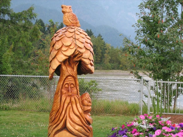
In Hope, we noticed many chainsaw carvings proudly displayed around the town. Hope has been appropriately tagged as the Chainsaw Carving Capital.

A bear carving on Wallace Street in downtown Hope.

Shown below is Levi Caya, who won first place and also People’s Choice in the 2021 Hope Chainsaw Carving Competition. There is an annual chainsaw competition in Hope.

See several of the chainsaw carvings around downtown Hope are shown below in the following pictures.


(Shown above is District of Hope British Columbia Administration Building.)


Above is a chainsaw carving of a bear with a fish, and an old man that is likely scared of the bear hiding inside a tree.


Wild Rose Campground is a Good Sam Park nestled between the Cascade Mountains and the Fraser River. We stayed one night on site #46 for $49.14 CA (or $36.03 US), with full hookups.


Above is a mural at the Wild Rose Campground, while below is a totem pole.

For dinner tonight, we had steak with leftover potatoes and corn on the cob.
We stayed inside the camper tonight and watched movies on dvds, as the smoke was closing in on us. Here's to hoping for a smoke-free journey tomorrow as we enter the United States and settle in the state of Washington for awhile!
Shirley & Mel


