Sunday, July 30, 2023
Happy 36th Birthday Ben!
Today turned out to be a very long, and difficult day. I'm calling it the day from Hell "Oh," as we traveled 399 miles in over 11 hours.

The day started out quite smoky a 55 degees and we had sprinkles off and on during our journey.

Our plans for today were to travel up the Dempster Highway to the Tombstone Territorial Park Campground located at about 44 miles along the highway.

We passed by the Klondike River Campground.


As we continued on, the sun was trying to peak out from behind the clouds.


We then passed by Henderson's Corner.


And then we came to the sign for the Dempster Highway and the Arctic Ocean. We then turned left onto the Dempster Highway.

The Dempster Highway, also referred to as Yukon Highway 5 and Northwest Territories Highway 8, is a highway in Canada that connects the Klondike Highway in Yukon to Inuvik, Northwest Territories on the Mackenzie River delta. The highway crosses the Peel and the Mackenzie rivers using a combination of seasonal ferry services and ice bridges. Year-round road access from Inuvik to Tuktoyaktuk opened in November 2017, with the completion of the Inuvik-Tuktoyaktuk Highway, creating the first all-weather road route connecting the Canadian road network with the Arctic Ocean.
The highway is named for North-West Mounted Police (NWMP) officer William Dempster, who earned renown for discovering the fate of a lost NWMP patrol in 1911. The highway begins 40 km (25 mi) east of Dawson City, Yukon on the Klondike Highway. There are no highway or major road intersections along the highway's route. It extends 457 miles in a north-northeasterly direction to Inuvik, NWT passing through Tombstone Territorial Park and crossing the Ogilvie and Richardson mountain ranges.
During the late 19th century, and in response to the Klondike Gold Rush, the North-West Mounted Police established a presence in the Yukon and Northwest Territories. Their activities included winter dog sled patrols between outposts and communities. One such patrol followed a route from Dawson City to the NWMP outpost at Fort McPherson, established in 1903.
In December 1910, NWMP Inspector Francis Joseph Fitzgerald led three men (Constable
Richard O'Hara Taylor, Constable George Francis Kinney and their guide, Special
Constable Sam Carter) on the annual winter patrol from Fort McPherson to Dawson City. Inspector
Fitzgerald and the three men had left Fort McPherson on December 21, 1910,
carrying mail and dispatches to Dawson City. They had left
Fort McPherson, with fifteen dogs, three sleds and enough food for thirty days.
The men felt no need to question whether they would reach their destination or
not. They successfully completed the first leg of the journey and hired native
Esau George to lead them through the next section. When he had completed his
part of the trip, Fitzgerald let George go, trusting in Carter to lead them
successfully to their destination.
Unfortunately, Carter had been on only one
patrol -- in the opposite direction -- and soon proved to be an inefficient
guide. By January 12, 1911, the patrol was lost as Carter was unable to find
Forrest Creek which would lead them to Dawson City. The team unsuccessfully
traveled up and down several streams in search of the correct one. The trip
became known as "The Lost Patrol," when they became lost on the trail, and subsequently died of exposure and starvation. When they failed to arrive in Dawson City as expected, Corporal Dempster and two constables were sent out on a rescue patrol in March 1911. Dempster and his men found the bodies of Fitzgerald's patrol on March 22, 1911.


We're now on the Dempster Highway, part of the Transcanada Trail and we have been warned that there are no emergency medical services along this section of the Dempster Highway.


We then crossed the blue three-span pony truss bridge over the Klondike River.


The Dempster Highway was all gravel now.


We drove past the signs for the Mackenzie River Crossing and the Peel River Crossing.


And then as we had been told -- we saw the electronic signs indicating "Forest Fire" and "Closure Possible."


We passed the turnoff for North Fork Road.


We could now see that the smoke was getting heavier and heavier. Yet, we continued on.


We passed the Beaver Creek Wilderness Retreat area.


After going for about 20 miles along the Dempster Highway, Mel and I both decided that because the smoke was getting heavier and heavier, and that we would probably not be able to see much of the beautiful views or even much at the Tombstone Territorial Campground, we should find a place to turn around and head back. So that is what we did.


Soon we had arrived back to the blue three-span pony truss bridge over the Klondike River that we had crossed earlier.


We're now off the Dempster Highway and are heading south on Highway 2 (Klondike Highway).


And then as has been the case all along this summer, we have run into some road construction.


And to make matters worse, it has started to rain. And it took us over 22 minutes to get through this road construction area.


Stewart Crossing was now 69 kilometers away.

The heavy smoke continued to hang in the air.


We crossed the bridge over Clear Creek, and then came to another bridge.


We passed by the turnoff for Moose Creek Campground.


And then we drove over the Moose Creek bridge.


Stewart Crossing was now two kilometers away. The Silver Trail branched off the Klondike Highway at Stewart Crossing. It followed the north fork of the Stewart River into the heart of the traditional territory of the Nacho Nyak Dun for a distance of 112 kilometers. At Mayo, the road turned north to Elsa, ending at Keno City.


Above is the Stewart River Bridge along the Klondike Highway.


We have arrived at the Silver Trail Visitor Center -- which usually provided infomation to tourists on Mayo and Keno, however it wasn't open. We decided to eat our lunch there and then we continued on down the highway as the smoke continues to get heavier.


The storyboard above told about the Mayo Road -- which was the first overland road between Whitehorse and Dawson City constructed in 1902. This road was extended in 1914 from Minto to Mayo Landing. Until the 1920s, the Overland Trail was a winter road. Freighters used coaches in the spring and fall, and sleighs as soon as there was enough snow. Over time, horse-drawn vehicles were replaced by trucks or small "cats."
As silver production in the region rose, the sternwheelers were sometimes unable to clear the backlog of freight and there was a need for an all-season overland route. The first all-weather road between Whitehorse and the Mayo Mining District was completed in 1950 and ferrys were installed on the new route at the Pelly, Stewart and Yukon rivers. United Keno Hills Mines maintained the road from 1953 to 1957 when the government took it over. By the 1950s, all of the ore concentrate was being shipped by road and the golden age of the Yukon sternwheelers was over.

The above storyboard told about the Silver Trail. As you travel along the Silver Trail from Stewart Crossing to Mayo, you will catch glimpses of the winding Stewart River. The river is a relatively shallow tributary of the Yukon River and the river pilots who worked this river were among the best in the Yukon. You will pass through a protected Moose Calving Habitat so stop at Devil's Elbow and hike up to the viewing platform to see some interesting wildlife. Five Mile Lake is a convenient recreation area and a good place to swim.

The above storyboard told about Stewart Crossing. The Stewart River was first prospected in 1883. By 1885, there were about 75 men making very good wages working the sand and gravel bars for gold. In 1886, the traders Leroy "Jack" McQuesten, Arthur Harper, and Al Mayo established a trading post at the mouth of the Stewart River to supply the miners but that same year a rich gold strike on the Fortymile River drew most of the prospectors out of this region. Alexander MacDonald was one of the first to prospect in the Mayo region and he named Mayo Lake for Al Mayo, who supplied him with an outfit or "grubstake." After the Klondike Gold Rush, the Stewart River remained with the prospectors looking for a reliable, if sparse, source of gold.


Above and below are some of the burnt areas along the highway.


We're now almost to Pelly Crossing.


And then we came upon another bridge crossing.


The town of Whitehorse, where we're planning to stay tonight was now 277 km (172 miles) away.


We passed McCabe Creek, which is a river in the Yukon Territory of Canada. A farm site on the creek was a checkpoint for the Yukon Quest sled dog race, but the checkpoint building burned down in 2009.


We passed McGregor Creek.


The Five Finger Rapids Recreation site was now only 2 km away.


We stopped at the Five Finger Rapids Recreation Site. The Five Finger Rapids, also known as the Five Fingers, are located on the Yukon River in Yukon, Canada. Four islands of composite rock divided the river into five narrow channels of which only the eastern is passable. Indigenous Canadians called the Five Finger Rapids "Tthi-cho Nadezhe," or "big rocks standing up."
The Five Finger Rapids were a common obstacle for gold seekers during the Klondike Gold Rush, the Yukon River was originally believed to be unnavigable above the rapids. Writer and artist Tappan Adney described them:
From 1900 to around 1927, blasting was undergone at the rapids, widening the channel by 20 feet.

The above storyboard told how the Five Finger islands and riverbank were composed conglomerate rock that was more resistant to erosion than the surrounding mudstone layers.

The above storyboard told about the Five Finger Rapids. The swift water and narrow channels through Five Finger Rapid posed a formidable danger to the overloaded boats and rafts of the 1898 Klondike stampeders. Whitehorse-bound sternwheelers had to winch themselves over a 1-2 foot drop in the navigable channel until the underwater obstacle was blasted away.

The above storyboard told about the Klondike Stampede. During the 1898 Klondike Gold Rush, thousands of prospectors navigated their handmade boats and rafts 800 miles from Bennett Lake to Dawson City. Five Finger Rapid was a major obstacle along the route and more than a few stampeders ended up in the water after choosing the wrong channel.

View of Five Finger Rapids (see above).

The Five Finger Rapids Recreation Site featured a viewing platform with a 219-step staircase (see above).


The above storyboard told us that the hills in the picture below were called the "Wood Cutters Range," to honor the woodcutters, who between 1898 and 1955, worked timelessly to stockpile wood for the fleet of sternwheelers on the Yukon River and its tributaries.

Another look at the 219-step staircase at the Five Finger Rapids Recreation Site. Just remember, what goes down, must come up, or vice versa.


After we left the Five Finger Rapids site, we once again ran into road construction.


We continued following Highway 2 South.


And yet another bridge . . .


Above is the "Welcome to the Hub of the Yukon" sign as we enter Carmacks. The Village of Carmacks is located in a spectacular wilderness setting at the confluence of the Yukon and Nordenskiold rivers. Considered by many to be 'the hub of the Yukon', it is situated 180 kilometers north of Whitehorse on the Klondike Highway, near its junction with the Robert Campbell Highway.
Thousands of years before the Klondike Gold Rush and the building of the Alaska and Klondike highways, the Carmacks area existed as a rest stop on a main trade route used by Indigenous People. These First Nations included coastal Tlingits, northern and interior Gwich’in and other Southern and Northern Tutchone groups.
Since becoming incorporated as a village November 1st, 1984, the Village of Carmacks now maintains a stable population of around 500 full-time residents. Many residents are employed by federal, territorial, First Nation and municipal governments. Private sector industries provide employment in the mining, construction, service industry, and tourism fields.

We continued on down the highway taking in the beautiful scenery.


We wanted to make one more stop before we got to the campgrond at Whitehorse -- and that stop was at Braeburn Lodge (about two hours from Whitehorse along the Klondike Highway).

Braeburn Lodge is a piece of history! The Lodge is a former roadhouse on the Whitehorse – Dawson Overland Trail. Between 1902 and 1914, the White Pass Stage Line ran sleighs and stage coaches between Whitehorse and Dawson. The Braeburn Roadhouse, located near Braeburn Lake and Braeburn Mountain, served travelers on the first section of the trail. Today, Braeburn Lodge and their excellent cinnamon buns serve travelers on the North Klondike Highway driving between Whitehorse and Dawson.


Inside Braeburn Lodge and you’ll find the owner Steve Watson (see above), who is a Harley clad, white-bearded guy that’s famous for his cinnamon buns. These heavy weight goodies are roughly the size of a dinner plate, and so famous that the nearby Braeburn airport also goes by the name of "Cinnamon Bun Airstrip." A folk icon in Canada known as Valdy once wrote the song "Cinnamon Bun Strip" about a runway across the road where bush pilots regularly land for buns and burgers.

These are touted as being the best "Cinnamon Buns" around. The cinnamon bun measures 8-1/2 inches in diameter and 1-1/2 inches high -- the size of plate. We bought one to take with us and it cost $15 Canadian (which converts to $10.88 in U.S.dollars). We shall see at breakfast tomorrow!

Above is some people enjoying the cinnamon bun in the Braeburn Lodge.

Since no one likes a dry cinnamon bun, I too wondered, “but what about the goo, is there enough goo on this cinnamon bun?” What if these cinnamon buns don't live up to the hype? What if they are all mass and no sass -- or sticky goo?


While we were at the Braeburn Lodge, I noticed that there was a portion of the "Dawson Overland Trail" starting here.
In 1902, the Yukon government contracted the White Pass & Yukon Route to build the first winter road between Dawson City and Whitehorse. Construction began that summer and the road was completed in November. It was 330 miles long -- shorter than the river route by about 70 miles -- and was built at a cost of $129,000. This winter road between Whitehorse and Dawson City became known as "The Dawson Overland Trail," and it marked the beginning of a new era of transportation in the Territory.

During the 1950s, Whitehorse and Dawson City were connected via highway (first built as an extension of the Mayo Road and today known as the North Klondike Highway), which effectively replaced the slow and rough Dawson Overland Trail. However, to this day most of the original route of the Dawson Overland Trail remains, and offers hardy travelers a challenging path back in time.


With the sticky cinnamon bun secured safely in the truck, we were back on the road again heading toward Whitehorse.


We passed Fox Lake Campground and Lake Laberge. For generations, Indigenous people have fished these waters and hunted in the mountains above its rocky, wooded shores. The lake's history is also interwoven with the Klondike Gold Rush of 1898, as it was one of the hurdles faced by gold seekers traveling down the Yukon river to the goldfields. Then, in 1907 Robert Service put the lake on the lips of people around the world with his famous poem, "The Cremation of Sam McGee," and the line, ". . . Was the night on the marge of Lake Laberge, I cremated Sam McGee."


We passed Fox Creek, Lake Laberge Campground, and Lake Laberge.


We passed Shallow Bay Road.


And then came to another bridge.


We then turned on Highway 1 South (Alaska Highway) toward Whitehorse.


We were close to our destination for the night in Whitehorse -- Pioneer RV Park.


So we checked in at the Pioneer RV Park in Whitehorse and got all set up on site #132 for three nights.


And then we found out the power was extremely bad, so we had to pack back up to leave in hopes of finding a better place to stay.

We stopped at the Real Canadian Superstore to see if we could camp in their parking lot overnight, but they didn't allow that. So we drove on, and went to see if there was any space available in the campground we had stayed in when we were last here -- Hi Country RV Park, but they didn't have anything available either.


It was getting late, and we tried one more place -- Wolf Creek Campground. As we pulled into the campground, it didn't look very promising.
.jpg)

There were many campers already filling the sites. And then as we were about to exit the campground -- the very last site was open. Site #46 (with no utilities available) -- was just perfect for us. At $20 Canadian per night (or $14.58 per night in U.S. dollars) -- quite a bargain. We got set up in it for a two night stay at around 9:30 p.m.


Mel fixed hamburgers for a late dinner. And we called it a night.
Monday, July 31, 2023
Today it was cloudy and rainy -- with a temperature of 64 degrees only reaching 70 degrees in the afternoon.

We enjoyed our plate-sized cinnamon bun for breakfast.

After breakfast, we drove into Whitehorse to do laundry, and then stopped at the Real Canadian Superstore for groceries.


We drove back to Wolf Creek Campground to put the groceries away and as well as our clean laundry. Then we drove back into town and ate lunch at Dairy Queen.

After lunch, we stopped at Yukon Brewing in Whitehorse.

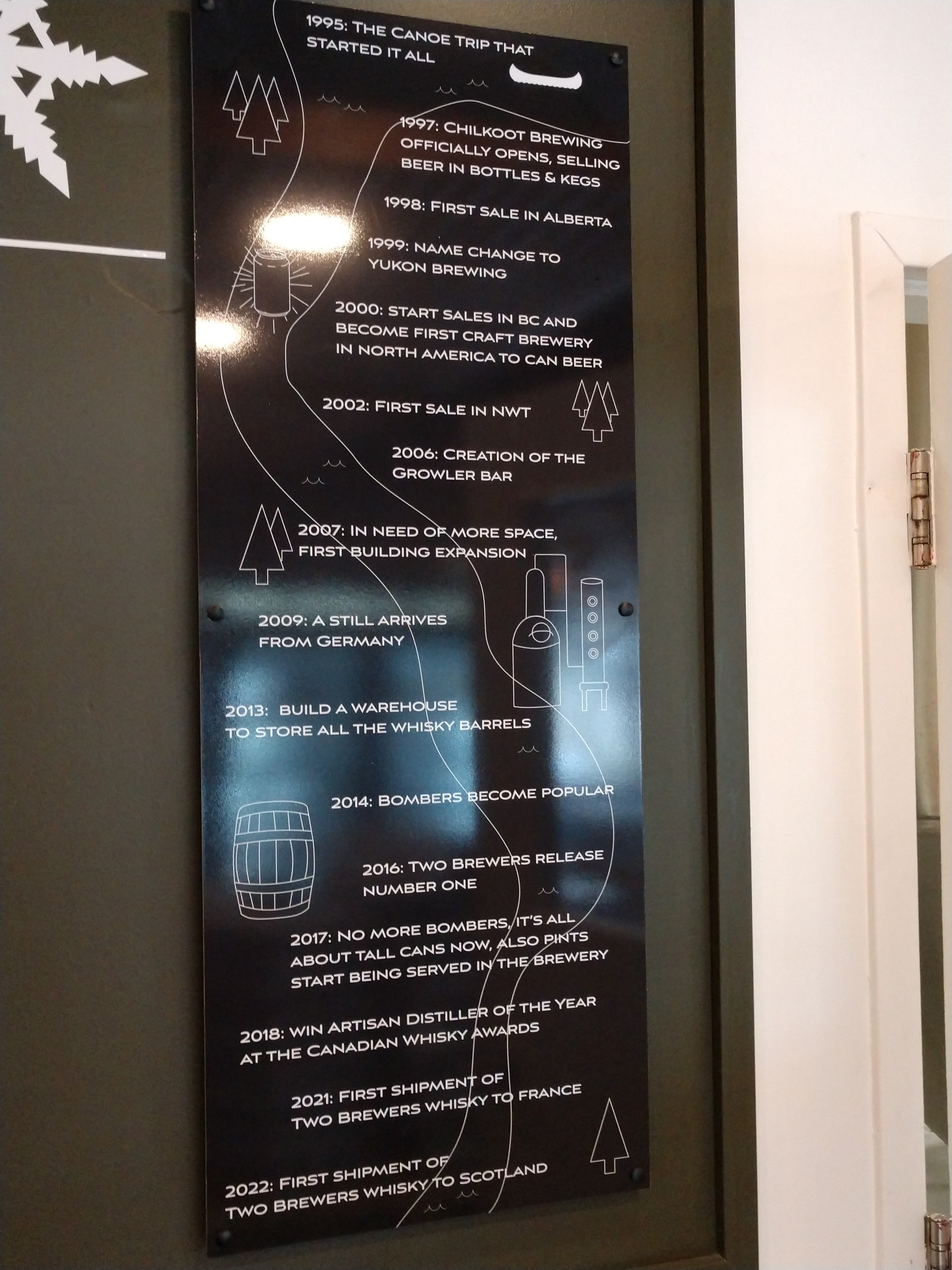

Mel enjoyed a few craft beers there and then we drove to Winterlong Brewing.


Here Mel also had a couple craft beers. I was fortunate to find the two books shown below in the little library they have for take or share. Looking forward to reading them.

We stopped at the Blueberry Carwash in Whitehorse to wash the truck and then filled up with gas at Petro Canada. We then went back to the campground for the evening. We had pork chops and salads for supper.
Peace and quiet at last!
Shirley & Mel


